Search Results
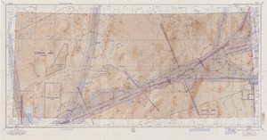
Elko sectional aeronautical chart, September 29, 1959
Date
1959-09-29
Description
52 x 110 cm. Relief shown by gradient tints, contours, and spot heights. Contour interval 1,000 feet. "Aeronautical data on this chart includes data received through Sept. 29, 1959." "Consult appropriate NOTAMS and Radio Facility Charts for supplemental data and current information." "Next edition is scheduled in approximately one year." "Base: Edition of May 1956. Revised Sept. 1958." "Lambert Conformal Conic Projection." "Standard Parallels 33° and 45°." "Elko compiled and printed at Washington, D. C. by the U. S. Coast and Geodetic Survey under authority of the Secretary of Commerce." "Principal sources: U. S. Geological Survey, U. S. Army Corps of Engineers, U. S. Air Force, U. S. Dept. of Agriculture, Civil Aeronautics Administration, and the U. S. Coast and Geodetic Survey." "Base: Edition of May 1956, revised Sept. 1958." "Detailed airport data and other useful information are printed on the back of this chart." Includes text, gradient tints scale and index to adjoining sheets. On verso: text, index map of sectional charts, inset maps of U.S. air defense identification zones and defense area, visual emergency signals, and charts. Original publisher: U.S. Coast and Geodetic Survey, Scale: 1:500,000.
Image
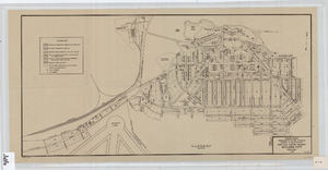
Cadastral map of Boulder City, Nevada, 1940
Date
1905-04-23
Description
A. M. S. Jan. 1940 in the lower left-hand corner. 1 map ; 61 x 30 cm. Cadastral map. "No. 40-1" in the lower right-hand corner. Shows block and lot numbers, buildings, water supply and sewage system, leased areas.
Image
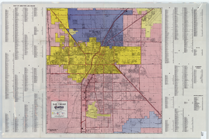
A general map of Las Vegas, 1969
Date
1905-05-22
Description
Color; 60 x 55 cm. on sheet 64 x 96 cm. At top left of map: Map of greater Las Vegas. Includes index.
Image
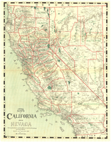
Map of California and Nevada, 1907
Date
1907
Description
Col. ; 57 x 43 cm., folded to 15 x 6 cm. Relief shown by hachures and spot heights. Published and copyrighted bu H.A. Candrian, 1907. "Mrs. H.A. Candrian, Dr'ng"--lower left corner.
Image

Map of Moapa River Indian Reservation, TPS. 14 & 15 S., RS. 65 & 66 E., M.D.M., Nevada, 1902
Date
1902
Description
As surveyed by V. S. Barber, 1902. Scale = 15 chains to an inch. "H Doc 65 57 2" in lower right corner. Relief shown by hachures. Shows township and range grid.
Image
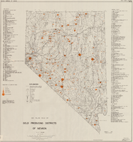
Map showing gold producing districts of Nevada, January 1967
Date
1967-01
Description
Scale 1:1,000,000. Series: Map (Nevada Bureau of Mines). 'January 1967.'
Text
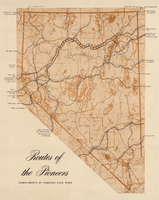
Map showing eighteenth- and nineteenth-century pioneer routes through the state of Nevada
Date
1941 to 1951
Description
Compliments of Harolds Club, Reno. Published between between 1941 and 1951? Scale [ca 1:1,250,000].
Image
Map, city of Henderson, Nevada, August 1, 1955
Date
1955-08-01
Description
'Compiled by Pioneer Title Insurance & Trust Company.' '8/1/55.' Includes street index.
Image
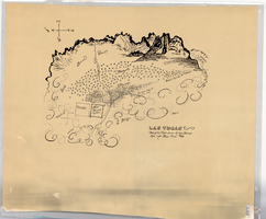
Hand-drawn map of Las Vegas, Nevada, circa 1855
Date
1850 to 1859
Description
Not drawn to scale. Relief shown pictorially. Facsimile of manuscript map. Oriented with north to left. Shows Las Vegas Mormon Fort, desert, mountains.
Image
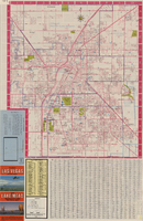
Las Vegas street map and Lake Mead Recreation Area pictorial map, 1979
Date
1979
Description
'Covering Las Vegas, North Las Vegas, Sunrise Manor, Winchester, Paradise and East Las Vegas from Craig Road on the north to Sunset Road on the south and Nellis Boulevard on the east to Jones Boulevard on the west' -- front panel. 'This tourist map has been published by CreaTours, Inc. in co-operation with the North Las Vegas Chamber of Commerce." 3rd ed. Scale [ca. 1:31,680. 1 in. to approx. 0.5 miles]. Includes indexes. Pictorial map of Lake Mead National Recreation Area on verso, by Cliff Segerblom. 'Lithographed by Creel Printing Company, Las Vegas, Nev.' Second edition, copyright 1977. 'Map not to scale due to artistic license.' Advertisements on map verso.
Text