Search Results
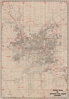
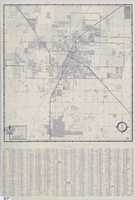
Street map of greater Las Vegas, Nevada, 1984
Date
1984
Description
'The professional street map of greater Las Vegas, Nevada. Detailed guide of Las Vegas, North Las Vegas, Paradise Valley & vicinity' -- front panel. ' Street index on map verso. Original publisher: Front Boy Service Co. Scale [ca. 1:44,352. 1 in. to approx. 0.70 mi.].
Text
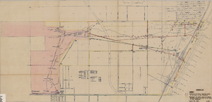
Maps showing sales of water production facilities of the Union Pacific Railroad Company and water distribution facilities of the Las Vegas Land and Water Co. to the Las Vegas Valley Water District, April 29, 1953
Date
1953
Archival Collection
Description
Union Pacific Railroad Co.
Image
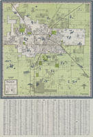
Map of Las Vegas and vicinity, 1963
Date
1963
Description
42 x 39 cm., folded to 21 x 9 cm. Panel title: Las Vegas and southern Nevada map and street guide. Includes index. Includes illustrations . Advertisement for Nevada State Bank, text with facts about Las Vegas and maps of Henderson, Boulder City and downtown Las Vegas on verso. "Courtesy of Nevada State Bank."--Panel. Original publisher: Thomas Bros. Maps.
Image
Street map of Las Vegas and vicinity, 1962
Date
1962
Description
43 x 40 cm., folded to 18 x 9 cm. Panel title: Las Vegas and vicinity. "Richfield" below title." Includes index. Text with facts about Las Vegas, photographs of Las Vegas and nearby tourist attractions and maps of Henderson, Boulder City and downtown Las Vegas on verso. Original publisher: Thomas Bros. Maps, Scale: One inch equals approximately 0.68 mile.
Image
Street map of the city of Las Vegas, North Las Vegas, the "Strip", 1955
Date
1955
Description
41 x 38 cm., folded to 28 x 15 cm. Panel title: Welcome map, greater Las Vegas area. Includes inset map of Meikle Manor subdivision. Includes list of churches in Las Vegas, mileages from Las Vegas to other cities in the Southwest and notes. Helldorado ed. 1955. Map is irregularly shaped. Index and advertisements on verso. Original publisher: Adco Publishing Co..
Image
Street map of Las Vegas and vicinity, 1960
Date
1960
Description
43 x 40 cm., folded to 18 x 9 cm. Panel title: Las Vegas and vicinity map. Includes index. Text with facts about Las Vegas, photographs of Las Vegas and nearby tourist attractions and maps of Henderson, Boulder City and downtown Las Vegas on verso. Library's copy 2 has notes handwritten in black ink. Original publisher: Thomas Bros. Maps.
Image
Street map of Las Vegas, 1966
Date
1966
Description
1966 ed. Color; 56 x 43 cm., folded to 23 x 10 cm. Panel title: Street map of Las Vegas and vicinity. On bottom of panel: Humble Oil & Refining Company. Index, photographs of Las Vegas scenes and nearby tourist attractions and map titled Lake Mead National Recreation Area, lower basin section on verso. Original publisher: H. M. Gousha Company.
Image

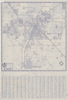
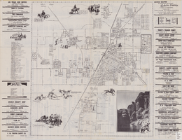
Street map of greater Las Vegas, Nevada, 1965-1966
Date
1965 to 1966
Description
Rev. 1965-1966 ed. 55 x 42 cm., folded to 29 x 12 cm. Panel title: Front Boy's official street map. Relief shown by spot heights. Copyright held by Russell A. Meador. Includes notes, quotations and indexes. Street index on verso. "Detailed guide of North Las Vegas, Las Vegas, Paradise Valley, and vicinity." Original publisher: Meador, Russell A.
Image
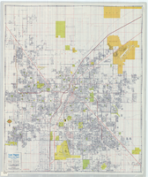
Street map of Las Vegas, North Las Vegas and vicinity, circa 1979
Date
1979
Description
Color; 88 x 73 cm., folded to 24 x 10 cm. "C6-87." Panel title: Las Vegas. Also shows Nellis Air Force Base. Indexes on verso. "Cartographic Department copyright 1979 by California State Automobile Association." Original publisher: California State Automobile Association. Cartographic Department. Scale: One kilometer = 5/8 mile
Image

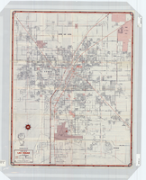
City map of Las Vegas, 1973
Date
1905-05-26
Description
Color; 55 x 45 cm., on sheet 95 x 47 cm., folded to 24 x 10 cm. Panel title: Las Vegas city map. Copyright held by Cardinal Publishing Company. Relief shown by hachures. Includes illustrations and advertisements. Index, text, illustrations, advertisements, and map of "Lake Mead National Recreation Area, lower basin section" on verso. Original publisher: Cardinal Publishing Company.
Image