
Search the Special Collections and Archives Portal

Search Results

Display    Results Per Page
Displaying results 19881 - 19890 of 21504

Gaming research files, 1960-2008

Level of Description

Series

Scope and Contents

Materials contain subject files, publications, newspaper articles, conference materials, and seminar coursebooks (1960-2008) collected by Gary W. Royer. The subject files are primarily comprised of brochures, video recordings, articles, and advertisements about the gaming industry. The publications include nationally circulating gaming newsletters, as well as booklets, essays, and magazines about the US gaming industry. The conference materials are primarily comprised of brochures, information packets, and copies of presentations from gaming conferences. Also included are seminar course books and video recordings produced by the University of Nevada, Las Vegas International Gaming Institute (IGI).

Archival Collection

Gary W. Royer Collection on Gaming
To request this item in person:
Collection Number: MS-00658
Collection Name: Gary W. Royer Collection on Gaming
Box/Folder: N/A

Archival Component

Clark County Museum Guild Records

Identifier

MS-00462

Abstract

The Southern Nevada, Clark County Museum Guild records consist of news clippings, meeting minutes, programs and other historical materials from 1983-1996.

Archival Collection

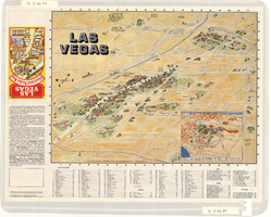
Map of metropolitan Las Vegas, Nevada area, circa 1957

Date

1955 to 1960

Description

Compiled and drawn by California State Automobile Association.--Panel ; "California State Automobile Association. Nevada Division." ; Includes indexes ; Includes inset maps of Nellis Air Force Base and area bounded on the north by Cheyenne Ave. and by Charleston Blvd. on the south. Signature of Elton M. Garrett of back of map. California State Automobile Association.

Text

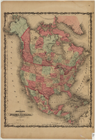
Map of North America, circa 1863

Date

1861 to 1865

Description

Scale [ca. 1:15,840,000. 1 inch to approx. 250 miles] (W 167°- -W27°/N 85°--N 10°) ; 1 map : hand col. ; 53 x 40 cm ; Hand colored ; Prime meridians: Greenwich and Washington, D.C. ; Includes mail routes and proposed railroad routes; Has decorative border ; Plates 15 and 16 from Johnson's new illustrated family atlas of the world ; Partial geographical index on verso ; Alternate title: North America Johnson and Ward

Text

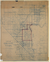
Map of Clark County, Nevada, 1927

Date

1927

Description

'Compiled by J.T. McWilliams from official county records, U.S. Land Dept. surveys, railroad co. field maps and many personal surveys. Made in 1927 by J.T. McWilliams, C.E.' Includes township and road districts, school districts, mining districts, railroads, wagon roads, trails, springs and artesian wells. Scale [ca. 1:316,800. 1 in. to approx. 5 miles] (W 116°--W 114°/N37--N35). Relief shown by hachures. Blueline print. Library's copy 1 has one area outlined by hand in red. Library's copy 2 has school districts outlined in red and green pencil and labeled in pencil by hand.

Image

Map of Las Vegas, Nevada, July 1947

Date

1947

Description

'Prepared by Porter & White Agency. Typography by Marc Wilkinson.' 'Travel-Aid. A Ballinger publication, copyright, July 1947.' Panel title: 'Las Vegas, Nevada invites you! : see Boulder Dam, Lake Mead.' Includes information on Las Vegas, business directory, advertisements and directory of service clubs. Advertisements, map of Boulder City, and map of southern Nevada area with advertisements on verso. Ballinger Publishing Company.

Text

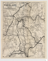
Map showing automobile routes to Hoover Dam and vicinity, circa 1934

Date

1930 to 1938

Description

'Prepared by the Automobile Club of Southern California.' 'burke' in lower right corner. '1352' in circle in lower left corner. Relief shown by hachures and spot heights. Shows mines, ranches, and springs. Scale [ca. 1:443,520] (W 115°30--W 114°--N 36°30/N 35°)

Image

Map of Las Vegas, North Las Vegas, and The Strip, 1956

Date

1956

Description

1956 ed. 'Compiled by Redwood Publishing Co. Copyright 1956 by Robert E. Barringer ... Las Vegas, Nevada.' Panel title: Welcome map, greater Las Vegas area and scenic routes to and from there. Map of California from San Francisco to Los Angeles to Las Vegas drawn by Beth Bergh. Includes notes and street index. Includes advertisements for Las Vegas and California businesses. Scale [ca. 1:35,640. 1 in. to approx. 0.56 mile].

Text

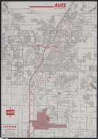
Map of metropolitan Las Vegas, Nevada, 1971

Date

1971

Description

At top of map: 'Avis Rent a Car System.' 'Copyright The H.M.Gousha Company... San Jose, Calif.' '8-SS-1044-S.' Scale [ca. 1:43,718]. 1 in. equals approx 0.69 miles. On verso: map of 'Las Vegas [and] Lake Mead Recreational Area, 1971 edition'; map of McCarran International Airport ('1274-S'); and list of Avis Rent A Car locations. H.M. Gousha Co.

Text

Map of the Las Vegas Strip, downtown Las Vegas and surrounding areas, 1987

Date

1987

Description

Panel title: Las Vegas illustrated pocket map. Bird's-eye view map of the Strip and downtown Las Vegas. Shows casinos, motels, golf courses, recreational vehicle parks, and other places of interest to tourists. Includes indexes. Includes text and inset map of locations of other cities and sites of interest to tourists in the surrounding states and their distances from Las Vegas. Travel Graphics International (Firm)

Text