Search Results
T-Shirt Color: Navy Blue; Front: Santee Fire Department; Back: 9-11-2001 FDNY, Silhouette Of New York City And Lady Liberty, approximately 2001-2012
Level of Description
File
Archival Collection
New York-New York Hotel and Casino 9-11 Heroes Tribute Collection
To request this item in person:
Collection Number: MS-00459
Collection Name: New York-New York Hotel and Casino 9-11 Heroes Tribute Collection
Box/Folder: Box 76
Collection Name: New York-New York Hotel and Casino 9-11 Heroes Tribute Collection
Box/Folder: Box 76
Archival Component
Photographs of Archie C. Grant Hall, Maude Frazier Hall, and students, approximately 1970-1979
Level of Description
File
Archival Collection
University of Nevada, Las Vegas School of Nursing Records
To request this item in person:
Collection Number: UA-00011
Collection Name: University of Nevada, Las Vegas School of Nursing Records
Box/Folder: Box 01
Collection Name: University of Nevada, Las Vegas School of Nursing Records
Box/Folder: Box 01
Archival Component
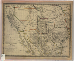
Map of Utah, New Mexico, Texas, California, Indian territory, and the northern states of Mexico, 1852
Date
1852-01-01
Description
At head of title: 'North America, sheet XV.' 'Published under the superintendence of the Society for Diffusion of Useful Knowledge.' At bottom center of map:'London, Charles Knight, Jany. 1st, 1852.' At bottom right of map: ' J. & C. Walker Sculpt.' Scale [1:7,500,000] 1 degree to 68.89 English miles (W 125°--W 92°/N 43°30?--N 22°30?). Relief shown by hachures. Atlas page number in lower margin: 144. Boundaries hand colored. Includes notes, locations of Indian tribes, population statistics. Charles Knight.
Image
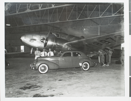
Photograph of the Lockheed 14, Chicago, 1938
Date
1938
Archival Collection
Description
A view of the Lockheed 14 surrounded by a small crowd while resting inside a hangar in Chicago.
Image
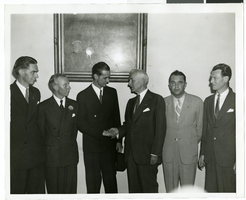
Photograph of Howard Hughes and other men, July 1938
Date
1938-07
Archival Collection
Description
Description printed on back of photograph: "A group at the State Department. Left to Right: Edward Lund, Harry MC. Connor, Howard Hughes, Secretary of State Cordell Hull, Lt. Thomas Thurlow and Richard Stoddart. July 1938."
Image
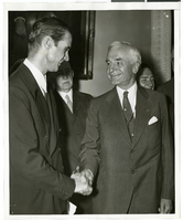
Photograph of Howard Hughes and other men, July 1938
Date
1938-07
Archival Collection
Description
Description printed on photograph's accompanying sheet of paper: "Howard Hughes after his round the world flight shaking hands with Secretary of State Cordell Hell as R. Walton Moore Counselor of the Department of State looks on. July 1938."
Image
Maude Hall and Archie Grant Hall, Nevada Southern University, approximately 1960-1969
Level of Description
File
Archival Collection
University of Nevada, Las Vegas Photograph Collection
To request this item in person:
Collection Number: PH-00062
Collection Name: University of Nevada, Las Vegas Photograph Collection
Box/Folder: Folder 36
Collection Name: University of Nevada, Las Vegas Photograph Collection
Box/Folder: Folder 36
Archival Component
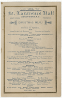
Christmas menu, 1884, St. Lawrence Hall
Date
1905-02-26
Archival Collection
Description
Restaurant: St. Lawrence Hall Location: Montreal, Quebec, Canada
Text
T-Shirt Color: Navy Blue; Front: Port Authority Police PAPD, Dept. Badge; Back: Always Honored Never Forgotten, Port Authority Police - New York, New Jersey 09/11/01, Dept. Badge, approximately 2001-2012
Level of Description
File
Archival Collection
New York-New York Hotel and Casino 9-11 Heroes Tribute Collection
To request this item in person:
Collection Number: MS-00459
Collection Name: New York-New York Hotel and Casino 9-11 Heroes Tribute Collection
Box/Folder: Box 90
Collection Name: New York-New York Hotel and Casino 9-11 Heroes Tribute Collection
Box/Folder: Box 90
Archival Component