Search the Special Collections and Archives Portal
Search Results
Remarks before the students at the Goddard Space Flight Center [15 July 1971], 1971 July 15 to 1971 July 20
Level of Description
File
Archival Collection
Howard Cannon Papers
To request this item in person:
Collection Number: MS-00002
Collection Name: Howard Cannon Papers
Box/Folder: Box 06 (Speeches)
Collection Name: Howard Cannon Papers
Box/Folder: Box 06 (Speeches)
Archival Component
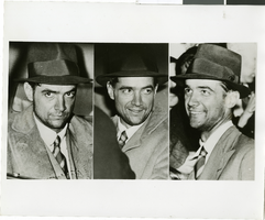
Photograph of Howard Hughes in New York, July 1938
Date
1938-07
Archival Collection
Description
Multiple, close up views of Howard Hughes in the back of an automobile in New York. Typed onto a piece of paper attached to the image: "Howard Hughes at Floyd Bennett Airport being interviewed after his record-breaking flight around the world. 7/14/38."
Image
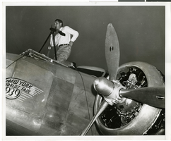
Photograph of Hiram "Tommy" Thurlow and the Lockheed 14, New York, New York, July 9, 1938
Date
1938-07-09
Archival Collection
Description
The black and white view of Hiram "Tommy" Thurlow and the Lockheed 14 aircraft in New York, New York. Typed on a piece of a paper attached to the image: "Floyd Bennett Airport, N.Y. Lieut. Hiram ("Tommy") Thurlow, of the Department of Commerce re-checks Howard Hughes' sleek Lockheed L-14 Super Electra before flight to Paris. 7/9/38."
Image
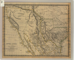
Map of Texas, California, New Mexico and the northern states of Mexico, October 15, 1842
Date
1842-10-15
Description
'Published under the superintendence of the Society for Diffusion of Useful Knowledge.' 'Published by Chapman & Hall, 186 Strand, 15 Oct. 1842.' 'J. & C. Walker, Sculpt.' Scale [ca. 1:7,600,000]. 1 in. to ca. 120 miles (W 125°--W 91°/N 43°--N 23° 30?). 1 map ; 31 x 39 cm. Relief indicated by hachures and spot heights. Shows elevations in yards. Includes notes on exploring expeditions, etc. Borders hand colored. Chapman & Hall.
Image
New York reception for Howard Hughes and his crew members after completing an around-the-world flight, 1938 July 15
Level of Description
File
Archival Collection
Howard Hughes Public Relations Photograph Collection
To request this item in person:
Collection Number: PH-00373
Collection Name: Howard Hughes Public Relations Photograph Collection
Box/Folder: Folder 11
Collection Name: Howard Hughes Public Relations Photograph Collection
Box/Folder: Folder 11
Archival Component
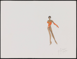
Aretha Franklin at Carnegie Hall, New York: costume design drawings, notes
Date
2003
Archival Collection
Description
Series III. Professional work in the United States: show production materials -- Revues, concerts, and theater production materials
Mixed Content
#05042: Mandel, 1983 July 15
Level of Description
File
Archival Collection
University of Nevada, Las Vegas Creative Services Records (1980s)
To request this item in person:
Collection Number: PH-00388-02
Collection Name: University of Nevada, Las Vegas Creative Services Records (1980s)
Box/Folder: N/A
Collection Name: University of Nevada, Las Vegas Creative Services Records (1980s)
Box/Folder: N/A
Archival Component
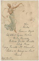
Hôtel Bristol menu, February 15, 1890
Date
1890-02-15
Archival Collection
Description
Note: Handwritten menu Restaurant: Hôtel Bristol
Text
Becker, Barry, 1974 July 15
Level of Description
File
Archival Collection
Frank Mitrani Photographs
To request this item in person:
Collection Number: PH-00332
Collection Name: Frank Mitrani Photographs
Box/Folder: Box 48
Collection Name: Frank Mitrani Photographs
Box/Folder: Box 48
Archival Component
Franklin, George, 1966 July 15
Level of Description
File
Archival Collection
Frank Mitrani Photographs
To request this item in person:
Collection Number: PH-00332
Collection Name: Frank Mitrani Photographs
Box/Folder: Box 05
Collection Name: Frank Mitrani Photographs
Box/Folder: Box 05
Archival Component
Pagination
Refine my results
Content Type
Creator or Contributor
Subject
Archival Collection
Digital Project
Resource Type
Year
Material Type
Place
Language
Records Classification
