Search Results
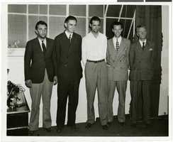
Photograph of Howard Hughes and other men, New York, July 14, 1938
Date
1938-07-14
Archival Collection
Description
Description printed on photograph's accompanying sheet of paper: "Group at [Gover] Whalen's home 7/14/38. (Daily News)." Howard Hughes is standing third from the left.
Image

Photograph of Howard Hughes and other men, New York, July 14, 1938
Date
1938-07-14
Archival Collection
Description
Description printed on photograph's accompanying sheet of paper: "Group at [Gover] Whalen's home 7/14/38. (Daily News)." Howard Hughes is standing third from the left.
Image
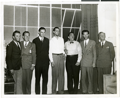
Photograph of Howard Hughes and other men, New York, July 14, 1938
Date
1938-07-14
Archival Collection
Description
Description printed on photograph's accompanying sheet of paper: "Group at [Gover] Whalen's home 7/14/38. (Daily News)." Howard Hughes is standing fourth from the left.
Image
PETN Stability and Compatibility - AEC, 1974 July 15
Level of Description
File
Archival Collection
Yucca Mountain Site Characterization Office Collection
To request this item in person:
Collection Number: MS-00091
Collection Name: Yucca Mountain Site Characterization Office Collection
Box/Folder: Box 56
Collection Name: Yucca Mountain Site Characterization Office Collection
Box/Folder: Box 56
Archival Component
#61573: Stage - Combat Workshop, 1997 July 15
Level of Description
File
Archival Collection
University of Nevada, Las Vegas Creative Services Records (1990s)
To request this item in person:
Collection Number: PH-00388-03
Collection Name: University of Nevada, Las Vegas Creative Services Records (1990s)
Box/Folder: N/A
Collection Name: University of Nevada, Las Vegas Creative Services Records (1990s)
Box/Folder: N/A
Archival Component
#61874: Theatre - Group Portraits, 1998 July 15
Level of Description
File
Archival Collection
University of Nevada, Las Vegas Creative Services Records (1990s)
To request this item in person:
Collection Number: PH-00388-03
Collection Name: University of Nevada, Las Vegas Creative Services Records (1990s)
Box/Folder: N/A
Collection Name: University of Nevada, Las Vegas Creative Services Records (1990s)
Box/Folder: N/A
Archival Component
#61875: Theatre - Group Portraits, 1998 July 15
Level of Description
File
Archival Collection
University of Nevada, Las Vegas Creative Services Records (1990s)
To request this item in person:
Collection Number: PH-00388-03
Collection Name: University of Nevada, Las Vegas Creative Services Records (1990s)
Box/Folder: N/A
Collection Name: University of Nevada, Las Vegas Creative Services Records (1990s)
Box/Folder: N/A
Archival Component
#61877: Martin, Myron - (Environmental), 1998 July 15
Level of Description
File
Archival Collection
University of Nevada, Las Vegas Creative Services Records (1990s)
To request this item in person:
Collection Number: PH-00388-03
Collection Name: University of Nevada, Las Vegas Creative Services Records (1990s)
Box/Folder: N/A
Collection Name: University of Nevada, Las Vegas Creative Services Records (1990s)
Box/Folder: N/A
Archival Component
W.A. Littell, standing portrait, 1887 July 15
Level of Description
File
Archival Collection
William Hillman Shockley Photograph Collection
To request this item in person:
Collection Number: PH-00241
Collection Name: William Hillman Shockley Photograph Collection
Box/Folder: Folder 02
Collection Name: William Hillman Shockley Photograph Collection
Box/Folder: Folder 02
Archival Component
Background Information on Nuclear Tests, July 15, 1957
Level of Description
Item
Archival Collection
Alice P. Broudy Papers on Broudy v. United States
To request this item in person:
Collection Number: MS-00097
Collection Name: Alice P. Broudy Papers on Broudy v. United States
Box/Folder: Box 20
Collection Name: Alice P. Broudy Papers on Broudy v. United States
Box/Folder: Box 20
Archival Component