Search Results
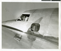
Photograph of Howard Hughes in his Lockheed 14 aircraft, Floyd Bennett Field, New York, July 10, 1938
Date
1938-07-10
Archival Collection
Description
The black and white view of Howard Hughes in his Lockheed 14 aircraft at Floyd Bennett Field in New York. Text printed on accompanying paper strip: "Hughes takes off on flight to Paris. Floyd Bennett Field, New York City-- Howard Hughes, multi-millionaire speed flyer, pictured in the nose of his Hughes Lockheed "Flying Laboratory" as Hughes and his picked crew of four prepared for the take-off to Paris and probably around the world on July 10th. A few minutes after this picture was taken, the giant ship lifted from the field to follow the trail blazed by Chrales A. Lindbergh. Credit Line (ACME) 7/10/38."
Image
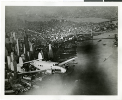
Photograph of the Lockheed 14 aircraft, July 1938
Date
1938-07
Archival Collection
Description
The black and white, skyline view of New York City with Lockheed 14 aircraft flying in the foreground. Typed onto script included with the image: "Howard Hughes plane Lockheed 14 in flight over lower New York City. To right in the background can be seen New York City's three bridges of the lower East River from front to rear: the Brooklyn Bridge, Manhattan Bridge, and the Williamsburg Bridge."
Image

Map of California, and territories of Utah, Nevada, Colorado, New Mexico and Arizona, 1864
Date
1864
Description
'Johnson's California, also Utah, Nevada, Colorado, New Mexico, and Arizona, published by A.J. Johnson, New York.' 'Entered according to act of Congress in the year 1864, by A.J. Johnson in the Clerks Office of the District Court of the United States for the southern district of New York.' Atlas page numbers in upper margin: 67-68. Relief shown by hachures. Prime meridian: Greenwich and Washington. Shows natural features, locations of Indian tribes, proposed railroad routes, routes of explorers, trails, county boundaries and populated places. Hand colored. On verso: 'Historical and statistical view of the West India Islands or Columbian Archipelago' (p. 80) and 'Historical and statistical view of Mexico and Central America' (p. 79). Scale [ca. 1:3,484,800]. 1 in. to ca. 55 miles (W 124°--W 102°/N 42°--N 32°).
Text
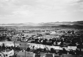
Film transparency of Boulder City, Nevada, December 15, 1933-June, 1934
Date
1933 to 1934
Archival Collection
Description
Panoramic view of houses from the water tank in Boulder City. This photo was taken between December 15, 1933 and June, 1934. Buildings that can be seen include City Hall (left), the Boulder Theater building (center), the Boulder Dam Hotel (right), and the Terminal Building with the Boulder Cafe (right).
Image
Restaurant in the Showboat Casino, Atlantic City, New Jersey, 1986
Level of Description
Item
Archival Collection
Showboat Atlantic City Photograph Collection
To request this item in person:
Collection Number: PH-00329
Collection Name: Showboat Atlantic City Photograph Collection
Box/Folder: Folder 01
Collection Name: Showboat Atlantic City Photograph Collection
Box/Folder: Folder 01
Archival Component
Gamblers in the Showboat Casino, Atlantic City, New Jersey, 1986
Level of Description
Item
Archival Collection
Showboat Atlantic City Photograph Collection
To request this item in person:
Collection Number: PH-00329
Collection Name: Showboat Atlantic City Photograph Collection
Box/Folder: Folder 01
Collection Name: Showboat Atlantic City Photograph Collection
Box/Folder: Folder 01
Archival Component
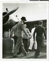
Photograph of Howard Hughes and the Lockheed 14 aircraft, Fairbanks, Alaska, July 15, 1938
Date
1938-07-15
Archival Collection
Description
The black and white view of Howard Hughes walking with other unidentified men toward the Lockheed 14 aircraft that was then being refueled. Hughes was then on his Around the World Flight where he visited Paris, Moscow, Fairbanks, and Alaska.
Image
Wilbur and Toni Clark at a formal dinner at the Hotel Astor in New York City, New York, 1958
Level of Description
File
Archival Collection
Toni and Wilbur Clark Photographs
To request this item in person:
Collection Number: PH-00302
Collection Name: Toni and Wilbur Clark Photographs
Box/Folder: Folder 10
Collection Name: Toni and Wilbur Clark Photographs
Box/Folder: Folder 10
Archival Component

Map of California, Utah, Nevada, Colorado, New Mexico and Arizona, circa 1867
Date
1865 to 1869
Description
39 x 56 cm. Relief shown by hachures. "Entered according to act of Congress in the year 1864, by A.J. Johnson in the Clerks Office of the United States for the Southern District of New York." Atlas page numbers in upper margin: 67-68. Primer meridians: Greenwich and Washington, D.C. On verso: History and statistical view of the West India islands or Columbian Archipelago and Historical and statistical view of Mexico and Central America. Shows proposed railroads, locations of Indian tribes, natural features, counties, mines, mail routes, trails and routes of exploring expeditions. Has decorative border. Southern part of Nevada was added to the state in 1867 and is part of Nevada on this map, but Lincoln County was established in 1867 and is not on this map. This map was still probably published in 1867 in spite of someone's having written "1864" in pencil in the lower right corner of the Library's copy. Original publisher: A.J. Johnson.
Image
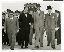
Photograph of Howard Hughes and Grover Whalen at Floyd Bennett Airfield, New York, July 14, 1938
Date
1938-07-14
Archival Collection
Description
A view of Howard Hughes and Grover Whalen leaving Floyd Bennett Airfield.
Image