Search Results
Hayes, Frederick O. R., "The Prospects for Casino Gambling in New York City", 1979
Level of Description
File
Archival Collection
Eugene Martin Christiansen Papers
To request this item in person:
Collection Number: MS-00561
Collection Name: Eugene Martin Christiansen Papers
Box/Folder: Box 079
Collection Name: Eugene Martin Christiansen Papers
Box/Folder: Box 079
Archival Component
Bars and nighctlubs: Stonewall Inn, New York City, 2009-2015
Level of Description
File
Archival Collection
Dennis McBride Collection on LGBTQ Las Vegas, Nevada
To request this item in person:
Collection Number: MS-00802
Collection Name: Dennis McBride Collection on LGBTQ Las Vegas, Nevada
Box/Folder: Box 03
Collection Name: Dennis McBride Collection on LGBTQ Las Vegas, Nevada
Box/Folder: Box 03
Archival Component
New York City 9/11 firefighter memorials, approximately 2001 to 2010
Level of Description
File
Archival Collection
American Red Cross Southern Nevada Chapter Records
To request this item in person:
Collection Number: MS-00600
Collection Name: American Red Cross Southern Nevada Chapter Records
Box/Folder: Box 09
Collection Name: American Red Cross Southern Nevada Chapter Records
Box/Folder: Box 09
Archival Component

Map of the city of Las Vegas, Nevada, June 1, 1946
Date
1946-06-01
Description
Scale [ca. 1:9,600. 1 in. to approx. 800 ft.]. Cadastral map. 'Compiled by Pioneer Title Insurance &Trust Company.' 'By Jack Asher, State Nev. Reg. Engr. No. 305.' 'Issue 5, 6/1/46.' Includes indexes. Pioneer Title Insurance &
Trust Company
Trust Company
Image
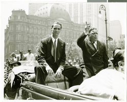
Photograph of Howard Hughes at his parade for Round the World flight, New York City, July 15, 1938
Date
1938-07-15
Archival Collection
Description
The view of Howard Hughes (left) and Mayor Fiorello Laguardia (right) seated in an automobile that was used in a parade dedicated to Hughes' completion of his Round the World flight in New York City, New York.
Image
Attorneys and statutory agents - appointment in New York City, 1911-1960
Level of Description
File
Archival Collection
Union Pacific Railroad Collection
To request this item in person:
Collection Number: MS-00397
Collection Name: Union Pacific Railroad Collection
Box/Folder: Box 56
Collection Name: Union Pacific Railroad Collection
Box/Folder: Box 56
Archival Component
Lockheed 14 aircraft over New York City, 1938 July
Level of Description
File
Archival Collection
Howard Hughes Public Relations Photograph Collection
To request this item in person:
Collection Number: PH-00373
Collection Name: Howard Hughes Public Relations Photograph Collection
Box/Folder: Folder 06
Collection Name: Howard Hughes Public Relations Photograph Collection
Box/Folder: Folder 06
Archival Component
Garden Pier, Atlantic City, New Jersey: photograph, 1936 to 1937
Level of Description
Item
Archival Collection
Larry Fotine Music collection
To request this item in person:
Collection Number: MS-01179
Collection Name: Larry Fotine Music collection
Box/Folder: Digital File 00
Collection Name: Larry Fotine Music collection
Box/Folder: Digital File 00
Archival Component
Steel Pier marquee, Atlantic City, New Jersey: photograph, 1951
Level of Description
Item
Archival Collection
Larry Fotine Music collection
To request this item in person:
Collection Number: MS-01179
Collection Name: Larry Fotine Music collection
Box/Folder: Digital File 00
Collection Name: Larry Fotine Music collection
Box/Folder: Digital File 00
Archival Component