Search Results
Photograph of Howard Hughes at his parade for Round the World flight, New York City, July 15, 1938
Date
1938-07-15
Archival Collection
Description
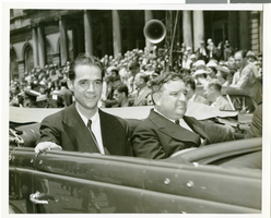
The black and white view of Howard Hughes (left) and Mayor Fiorello Laguardia (right) seated in an automobile that was used in a parade dedicated to Hughes' completion of his Round the World flight in New York City, New York.
Image

Map of California and Territories of New Mexico and Utah, 1862
Date
1862
Description
Scale [ca. 1:3,231,360. 1 in. to approx. 51 miles] (W 125°00--W 103°30/N 42°00--N 31°45) ; 1 map : hand col. ; 40 x 60 cm., on sheet 46 x 68 cm ; Relief indicated by hachures and spot heights ; Prime meridians: Greenwich and Washington, D.C ; Decorative border ; Hand colored ; Atlas p. numbers in upper margin: 58-59 ; Date est. from territorial borders and county configuration ; Shows natural features, locations of Indian tribes, proposed railroad routes, routes of explorers, trails, county boundaries and populated places ; Johnson and Ward
Image
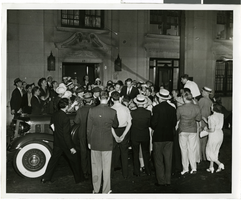
Howard Hughes talking to members of the press, possibly about his completion of his around-the-world flight in New York City, New York, 1938
Level of Description
File
Archival Collection
Howard Hughes Public Relations Photograph Collection
Archival Component
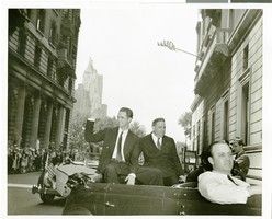
Howard Hughes and crew in parade up Broadway after record-breaking around-the-world flight New York, New York, 1938 July 15
Level of Description
File
Archival Collection
Howard Hughes Public Relations Photograph Collection
Archival Component
Music Hall New Years Eve Gala Dinner 1969-1970, menu, 1969
Level of Description
File
Archival Collection
UNLV University Libraries Menu Collection
Archival Component
Photograph of Howard Hughes at his parade for Round the World flight, New York City, July 15, 1938
Date
1938-07-15
Archival Collection
Description
Typed onto the back of the image: "New York welcomes Howard Hughes. Howard Hughes and Mayor La Guardia in car. 7/15/38."
Image
Howard Hughes Howard Hughes and New York Mayor Fiorello La Guardia, 1938 July 15
Level of Description
File
Archival Collection
Howard Hughes Public Relations Photograph Collection
Archival Component
Howard Hughes is appointed Aeronautic Adviser to the 1939 New York World's Fair by Grover Whalen, 1938
Level of Description
File
Archival Collection
Howard Hughes Public Relations Photograph Collection
Archival Component
Photograph of Howard Hughes after completing his Round The World flight, New York, July 15, 1938
Date
1938-07-15
Archival Collection
Description
Text typed onto a piece of paper attached to the image: "Howard Hughes strutting across a New York hotel lobby after completing a Round The World flight. 7-15-38. (Press Association)."
Image

Map of California, with territories of Utah, Nevada, Colorado, New Mexico, and Arizona, 1864
Date
1864
Description
40 x 62 cm. Relief shown by hachures. Prime meridians: Greenwich and Washington. Page numbers at top: 58-59. "Entered according to act of Congress in the year 1864 by A. J. Johnson in the Clerk's Office of the District Court of the United States for the Southern District of New York." Original publisher: Johnson and Ward.
Image