Search the Special Collections and Archives Portal
Search Results

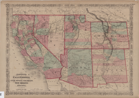
Map of California, Utah, Nevada, Colorado, New Mexico and Arizona, circa 1867
Date
1865 to 1869
Description
39 x 56 cm. Relief shown by hachures. "Entered according to act of Congress in the year 1864, by A.J. Johnson in the Clerks Office of the United States for the Southern District of New York." Atlas page numbers in upper margin: 67-68. Primer meridians: Greenwich and Washington, D.C. On verso: History and statistical view of the West India islands or Columbian Archipelago and Historical and statistical view of Mexico and Central America. Shows proposed railroads, locations of Indian tribes, natural features, counties, mines, mail routes, trails and routes of exploring expeditions. Has decorative border. Southern part of Nevada was added to the state in 1867 and is part of Nevada on this map, but Lincoln County was established in 1867 and is not on this map. This map was still probably published in 1867 in spite of someone's having written "1864" in pencil in the lower right corner of the Library's copy. Original publisher: A.J. Johnson.
Image

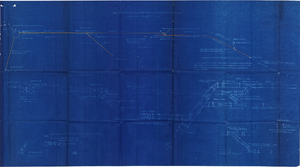
Plan of proposed new well pipe and fittings for Las Vegas, Nevada, 1936
Date
1936
Archival Collection
Description
Blueprint. Written on back of map:: 'Purposed [sic] new transmission lines--1936--transits.' Las Vegas Land and Water Company?
Image

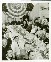
Photograph of a luncheon for the completion of Howard Hughes' Round the World flight, New York City, July 15, 1938
Date
1938-07-15
Archival Collection
Description
Typed onto a piece of paper attached to the image: "Fete, Hughes, and crew at Luncheon. Left to right at the head of the table are Harry P. Connor, navigator of the Hughes plane, Grover Whalen, Howard hughes, Mayor Fiorello Laguardia of New York City, Thomas Thurlow, Navigator, Richard Stoddart, radio engineer, and Edward Lund, flight engineer. At the bottom center of the photo is William Randolph Hearst, Jr., son of the publisher. 7/15/38"
Image
"Yankee Baseball Greats 1938" photograph, 1938
Level of Description
File
Archival Collection
Nat Hart Professional Papers
To request this item in person:
Collection Number: MS-00419
Collection Name: Nat Hart Professional Papers
Box/Folder: Box 16 (Restrictions apply)
Collection Name: Nat Hart Professional Papers
Box/Folder: Box 16 (Restrictions apply)
Archival Component

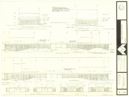
Architectural drawing of concert hall and drama theater, University of Nevada, Las Vegas, exterior elevations, November 5, 1969
Date
1969-11-05
Archival Collection
Description
Exterior elevations for the concert hall and drama theater on the University of Nevada, Las Vegas campus, including a connecting courtyard. These buildings would become the Artemus W. Ham Concert Hall and the Judy Bayley Theatre. Sheet 6 of 35. "Drawn by G.T. Checked by K.D. Job number 6828. Scale 1/16" = 1'-0". Date Nov. 5, 1969"
Site Name: University of Nevada, Las Vegas
Address: 4505 S. Maryland Parkway
Image
Plan entitled "New City Hall" and other unidentified building and site plans, 2009, undated
Level of Description
File
Archival Collection
Mark L. Fine Papers
To request this item in person:
Collection Number: MS-00696
Collection Name: Mark L. Fine Papers
Box/Folder: Oversized Box 7
Collection Name: Mark L. Fine Papers
Box/Folder: Oversized Box 7
Archival Component
Spectators surround a Lockheed-14 on a runway at Floyd Bennett Airport, Brooklyn, New York, 1938 July 10
Level of Description
File
Archival Collection
Howard Hughes Professional and Aeronautical Photographs
To request this item in person:
Collection Number: PH-00321
Collection Name: Howard Hughes Professional and Aeronautical Photographs
Box/Folder: Folder 07
Collection Name: Howard Hughes Professional and Aeronautical Photographs
Box/Folder: Folder 07
Archival Component
Howard Hughes in a New York hotel lobby after completing an around-the-world flight, 1938 July 15
Level of Description
File
Archival Collection
Howard Hughes Public Relations Photograph Collection
To request this item in person:
Collection Number: PH-00373
Collection Name: Howard Hughes Public Relations Photograph Collection
Box/Folder: Folder 10
Collection Name: Howard Hughes Public Relations Photograph Collection
Box/Folder: Folder 10
Archival Component
Howard Hughes in car receiving the applause of the crowd during his reception in New York, 1938 July 15
Level of Description
File
Archival Collection
Howard Hughes Public Relations Photograph Collection
To request this item in person:
Collection Number: PH-00373
Collection Name: Howard Hughes Public Relations Photograph Collection
Box/Folder: Folder 10
Collection Name: Howard Hughes Public Relations Photograph Collection
Box/Folder: Folder 10
Archival Component
Howard Hughes in his Lockheed 14 aircraft, Floyd Bennett Field, New York, 1938 July 10
Level of Description
File
Archival Collection
Howard Hughes Public Relations Photograph Collection
To request this item in person:
Collection Number: PH-00373
Collection Name: Howard Hughes Public Relations Photograph Collection
Box/Folder: Folder 06
Collection Name: Howard Hughes Public Relations Photograph Collection
Box/Folder: Folder 06
Archival Component
Pagination
Refine my results
Content Type
Creator or Contributor
Subject
Archival Collection
Digital Project
Resource Type
Year
Material Type
Place
Language
Records Classification
