Search Results
Police lined up ready for the start of the Howard Hughes parade, 1938 July 15
Level of Description
File
Archival Collection
Howard Hughes Public Relations Photograph Collection
Archival Component
Music Hall New Years Eve Gala Dinner 1969-1970, menu, 1969
Level of Description
File
Archival Collection
UNLV University Libraries Menu Collection
Archival Component
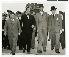
Howard Hughes is appointed Aeronautic Adviser to the 1939 New York World's Fair by Grover Whalen, 1938
Level of Description
File
Archival Collection
Howard Hughes Public Relations Photograph Collection
Archival Component

Map of California, Nevada, Utah, Colorado, Arizona & New Mexico, circa 1867
Date
1865 to 1869
Description
39 x 62 cm. Relief shown by hachures and spot heights. Prime meridian: Greenwich and Washington. Hand colored. Shows natural features, populated places, routes of mail steamships, routes of explorers, locations of Indian tribes, railroad routes, and proposed railroad routes. In top margin: No. 80-81. On verso: New Mexico, Arizona, Colorado, Idaho, Dakota (statistics and other information) and The state of California (statistics and other information). Original publisher: G.W. and C.B. Colton.
Image

Map of California, and territories of Utah, Nevada, Colorado, New Mexico and Arizona, 1864
Date
1864
Description
'Johnson's California, also Utah, Nevada, Colorado, New Mexico, and Arizona, published by A.J. Johnson, New York.' 'Entered according to act of Congress in the year 1864, by A.J. Johnson in the Clerks Office of the District Court of the United States for the southern district of New York.' Atlas page numbers in upper margin: 67-68. Relief shown by hachures. Prime meridian: Greenwich and Washington. Shows natural features, locations of Indian tribes, proposed railroad routes, routes of explorers, trails, county boundaries and populated places. Hand colored. On verso: 'Historical and statistical view of the West India Islands or Columbian Archipelago' (p. 80) and 'Historical and statistical view of Mexico and Central America' (p. 79). Scale [ca. 1:3,484,800]. 1 in. to ca. 55 miles (W 124°--W 102°/N 42°--N 32°).
Text
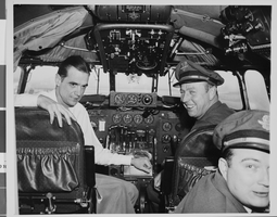
Photograph of Howard Hughes in cockpit, New York, February 15, 1946
Date
1946-02-15
Archival Collection
Description
Description given with photo: "After Non-Stop Coast to Coast Flight -- Pilot Howard Hughes (left) millionaire flier and movie producer, co-pilot Joseph Bartles, and navigator Robert Stevens, relax at the controls of their Lock-heed Constellation after landing at LaGuardia Field in new York City, Feb. 15 on Pre-Inaugural non-stop coast to coast flight from Burbank, Calif. the Constellation, named "Start of California" and carrying 34 passengers, including movie stars and a crew of seven, landed at LaGuardia Field eight hours and 38 minutes after leaving Burbank. 22/15/46."
Image
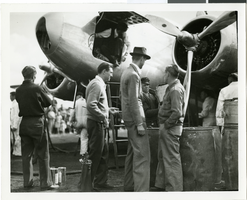
Photograph of Howard Hughes and the Lockheed 14 aircraft, Fairbanks, Alaska, July 15, 1938
Date
1938-07-15
Archival Collection
Description
The black and white view of Howard Hughes walking with other unidentified men toward the Lockheed 14 aircraft that was then being refueled. Hughes was then on his Around the World Flight where he visited Paris, Moscow, Fairbanks, and Alaska.
Image
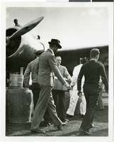
Photograph of Howard Hughes and Grover Whalen at Floyd Bennett Airfield, New York, July 14, 1938
Date
1938-07-14
Archival Collection
Description
A view of Howard Hughes and Grover Whalen leaving Floyd Bennett Airfield.
Image

Map of California, Utah, Nevada, Colorado, New Mexico and Arizona, circa 1867
Date
1865 to 1869
Description
39 x 56 cm. Relief shown by hachures. "Entered according to act of Congress in the year 1864, by A.J. Johnson in the Clerks Office of the United States for the Southern District of New York." Atlas page numbers in upper margin: 67-68. Primer meridians: Greenwich and Washington, D.C. On verso: History and statistical view of the West India islands or Columbian Archipelago and Historical and statistical view of Mexico and Central America. Shows proposed railroads, locations of Indian tribes, natural features, counties, mines, mail routes, trails and routes of exploring expeditions. Has decorative border. Southern part of Nevada was added to the state in 1867 and is part of Nevada on this map, but Lincoln County was established in 1867 and is not on this map. This map was still probably published in 1867 in spite of someone's having written "1864" in pencil in the lower right corner of the Library's copy. Original publisher: A.J. Johnson.
Image
Photograph of Howard Hughes and the Lockheed 14 aircraft, Fairbanks, Alaska, July 15, 1938
Date
1938-07-15
Archival Collection
Description
The black and white view of Howard Hughes standing with several unidentified men near the Lockheed 14 aircraft that was then being refueled. Hughes was then on his Around the World Flight where he visited Paris, Moscow, Fairbanks, and Alaska.
Image