Search Results
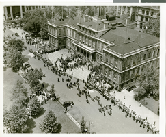
Photograph of a parade for Howard Hughes, New York City, July 15, 1938
Date
1938-07-15
Archival Collection
Description
The black and white view of a parade being held in celebration of Howard Hughes' completion of his Around the World flight in New York City, New York. Typed onto a piece of paper attached to the image: "New York welcoming Howard Hughes - General scene outside City Hall. 7/15/38."
Image
#71379: Pictures of and from Hospitality Hall, February 15, 2017, 2017 February 15
Level of Description
Item
Archival Collection
University of Nevada, Las Vegas Creative Services Records (2010s)
Archival Component
Breaking ground on the construction of the new union hall on Commerce Street, 1990s
Level of Description
File
Archival Collection
Culinary Workers Union Local 226 Las Vegas, Nevada Photographs
Archival Component
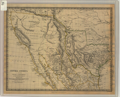
Map of Texas, California, New Mexico and the northern states of Mexico, October 15, 1842
Date
1842-10-15
Description
'Published under the superintendence of the Society for Diffusion of Useful Knowledge.' 'Published by Chapman & Hall, 186 Strand, 15 Oct. 1842.' 'J. & C. Walker, Sculpt.' Scale [ca. 1:7,600,000]. 1 in. to ca. 120 miles (W 125°--W 91°/N 43°--N 23° 30?). 1 map ; 31 x 39 cm. Relief indicated by hachures and spot heights. Shows elevations in yards. Includes notes on exploring expeditions, etc. Borders hand colored. Chapman & Hall.
Image
#03693: Artemus W. Ham Concert Hall, 1979 November 15
Level of Description
File
Archival Collection
University of Nevada, Las Vegas Creative Services Records (1970s)
Archival Component
"Las Vegas Town Hall, Beltway", 1996 April 15
Level of Description
Item
Archival Collection
UNLV TV Audiovisual Collection
Archival Component
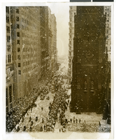
Photograph of a parade procession, New York, July 15, 1938
Date
1938-07-15
Archival Collection
Description
Description printed on photograph's accompanying sheet of paper: "New York reception for Howard Hughes and his four companions after they completed a round the world flight. 7/15/38."
Image
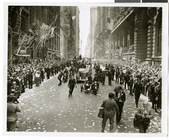
Photograph of a parade procession, New York, July 15, 1938
Date
1938-07-15
Archival Collection
Description
Description printed on photograph's accompanying sheet of paper: "New York reception for Howard Hughes and his companions after completing a round the world flight. 7-15-38 (Press Association)."
Image

Map of California and territories of New Mexico and Utah, circa 1861
Date
1859 to 1862
Description
'Compiled, drawn, and engraved under the supervision of J.H. Colton and A.J. Johnson.' Relief shown by hachures and spot heights. Scale [ca. 1:3,041,280]. 1 in. to approx. 48 miles (W 124°--W 103°/N 42°--N 31°). Hand colored
Prime meridians: Greenwich and Washington
Plates 54 & 55 removed from Johnson's New illustrated family atlas of the world, with descriptions geographical, statistical and historical ... New York, 1862
Title page of atlas.
Prime meridians: Greenwich and Washington
Plates 54 & 55 removed from Johnson's New illustrated family atlas of the world, with descriptions geographical, statistical and historical ... New York, 1862
Title page of atlas.
Image
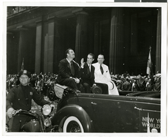
Photograph of a parade procession for Howard Hughes, New York, July 15, 1938
Date
1938-07-15
Archival Collection
Description
A view of Grover Whalen, Howard Hughes, and Al Lodwick riding in the back of an automobile during a parade procession. Description printed on back of photograph: "Howard Hughes welcomed at City Hall, New York. General scene. 7/15/38."
Image