Search the Special Collections and Archives Portal
Search Results
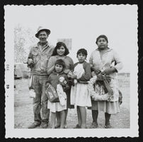
Photograph of Native American family, Pahrump (Nev.), December 1959
Date
1959-12
Archival Collection
Description
Native American family in Pahrump, Nevada, poses for a family portrait holding Christmas toys and a wreath. Inscription with photo reads: "The Indians were allowed to pick the wild holly. This family made me a holly wreath each Christmas which I prized and carefully stored. It was one of the families I delived Christmas toys, fruit, candy, and clothing to each year. The children are holding things I gave them." [Identified by Dorothy Dorothy]
Image
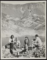
Photograph of people picnicking at Paint Pots at Fortification Hill, Boulder City (Nev.), 1940s
Date
1940 to 1949
Archival Collection
Description
Individuals sit and picnic on rocks at Fortification Hill. Colorful rock formations at foot of Hill called "Paint Pots." All of the people in the photo are unidentified, taken by Bureau of Reclamation, Boulder City, Nevada.
Image
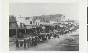
Photograph of funeral procession down Main Street, Tonopah (Nev.), February 1907
Date
1907-02
Archival Collection
Description
Funeral Procession walks down Main Street in Tonopah, Nevada in February, 1907. Mourners primarily wear black and the line stretches as far as the picture can see. Procession was for Orley R. Wardle, brother of Austin Wardle. Included with photograph is a Xerox of a letter to Dr. Elizabeth Patrick from Luella and Austin [Wardle?], dated May 19, 1982. See Image 0145 0001, pho025020 for more information about letter.
Image
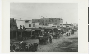
Photograph of funeral procession with horse-drawn carriages, Tonopah (Nev.), February, 1907
Date
1907-02
Archival Collection
Description
Funeral Procession travels down Main Street in Tonopah, Nevada in February, 1907. Mourners stand in dark coats and garments while horse-drawn carriages carry some passengers. Included with photograph is a Xerox of a letter to Dr. Elizabeth Patrick from Luella and Austin [Wardle?], dated May 19, 1982. See Image 0145 0001, pho025020 for more information about letter.
Image
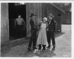
Rex Bell in movie still from unidentified movie: photographic print
Date
1880 to 1979
Archival Collection
Description
Dorothy Bell Scans UNLV-Public Lands Institute
Image
Audio recording clip of interview with NDE Immersion Group by Suzanne Becker, January 13, 2006
Date
2006-01-13
Archival Collection
Description
Narrator affiliation: Peace Studies, Nevada Desert Experience
Sound
Audio recording clip of interview with Zenna Mae and Eugene Bridges by Mary Palevsky, November 19, 2004
Date
2004-11-19
Archival Collection
Description
Narrator affiliation: Downwinder (Salt Lake City, Utah)
Sound
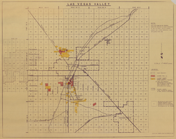
Map of Las Vegas Valley, 1968
Date
1968
Description
'This map compiled by General Drafting Service to show purchases in the Las Vegas area by Howard Hughes and others reported to be affiliated with him.' Shows land owned by Howard Hughes and land owned by Hughes Tool Company. Includes locations of casinos on Las Vegas Strip. Original publisher: General Drafting Service. Scale [ca. 1:48,000]. 1 in. to 4,000 feet. Hand-colored.
Image
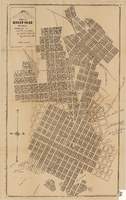
Map of Goldfield, Nevada, April 25, 1907
Date
1907-04-25
Description
'Compiled by James H. Parks, U.S. Deputy Min. Sur., Box 655, Goldfield, Nev. April 25, 1907.' 'Nevada Press Company, Carson City, Nevada.' Scale: [ca. 1:4,800] 1 inch = 400 ft. Plat map. Library's copy has notes handwritten in pencil along right margin with arrows to locations on map: "Ramsey Street ended Columbia St." "MacMaskrs office." "Lived on Euclid ave in adobe house." " Lived in Tent House Sundog Ave."
Image

Map of the city of Las Vegas, North Las Vegas, "the Strip," 1960
Date
1960
Description
1960 edition. 41 x 43 cm. Copyright held by Robert E. Barringer. Title in upper-right corner of map: Las Vegas area map. Irregularly-shaped map. Includes index, notes, list of Las Vegas schools and inset maps of East Las Vegas (Whitney) and Wherry housing area on Nellis Air Force Base. Original publisher: Redwood Publishing Co..
Image
Pagination
Refine my results
Content Type
Creator or Contributor
Subject
Archival Collection
Digital Project
Resource Type
Year
Material Type
Place
Language
Records Classification
