Search Results
#69724: College of Education Tier 1 task force symposium and reception in Greenspun Hall on May 15, 2014, 2014 May 15
Level of Description
File
Archival Collection
University of Nevada, Las Vegas Creative Services Records (2010s)
To request this item in person:
Collection Number: PH-00388-05
Collection Name: University of Nevada, Las Vegas Creative Services Records (2010s)
Box/Folder: Digital File 00
Collection Name: University of Nevada, Las Vegas Creative Services Records (2010s)
Box/Folder: Digital File 00
Archival Component
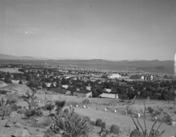
Film transparency of Boulder City, Nevada, December 15, 1933-June, 1934
Date
1933 to 1934
Archival Collection
Description
Panoramic view of houses from the water tank in Boulder City. This photo was taken between December 15, 1933 and June, 1934.
Image
Framed aerial photograph of Boulder City, Nevada, 1976 July
Level of Description
File
Archival Collection
Elton and Madelaine Garrett Photograph and Architectural Drawing Collection
To request this item in person:
Collection Number: PH-00265
Collection Name: Elton and Madelaine Garrett Photograph and Architectural Drawing Collection
Box/Folder: Oversized Box 20
Collection Name: Elton and Madelaine Garrett Photograph and Architectural Drawing Collection
Box/Folder: Oversized Box 20
Archival Component
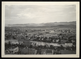
Photograph of Boulder City, Nevada, between December 15, 1933 and June, 1934
Date
1933 to 1934
Archival Collection
Description
Panoramic view of houses in Boulder City.
Image
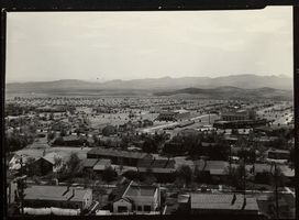
Photograph of Boulder City, Nevada, between December 15, 1933 and June, 1934
Date
1933 to 1934
Archival Collection
Description
Panoramic view of houses from the water tank in Boulder City.
Image
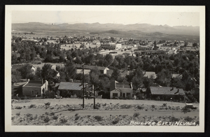
Postcard of Boulder City, Nevada, between December 15, 1933 and June, 1934
Date
1933 to 1934
Archival Collection
Description
Panoramic view of houses from the water tank in Boulder City.
Image
Birth announcement for Nila and Nola Ullom, 1919 July 15
Level of Description
File
Archival Collection
Ullom-Brockman Family Papers
To request this item in person:
Collection Number: MS-00211
Collection Name: Ullom-Brockman Family Papers
Box/Folder: Box 01
Collection Name: Ullom-Brockman Family Papers
Box/Folder: Box 01
Archival Component
#05037: Athletic GPA Honors Convocation, 1983 July 15
Level of Description
File
Archival Collection
University of Nevada, Las Vegas Creative Services Records (1980s)
To request this item in person:
Collection Number: PH-00388-02
Collection Name: University of Nevada, Las Vegas Creative Services Records (1980s)
Box/Folder: N/A
Collection Name: University of Nevada, Las Vegas Creative Services Records (1980s)
Box/Folder: N/A
Archival Component
#05038: Radiology Technology Annual Awards, 1983 July 15
Level of Description
File
Archival Collection
University of Nevada, Las Vegas Creative Services Records (1980s)
To request this item in person:
Collection Number: PH-00388-02
Collection Name: University of Nevada, Las Vegas Creative Services Records (1980s)
Box/Folder: N/A
Collection Name: University of Nevada, Las Vegas Creative Services Records (1980s)
Box/Folder: N/A
Archival Component
City Ordinances, 1911 July 18 to 1933 March 31
Level of Description
File
Archival Collection
Las Vegas City Commission Records
To request this item in person:
Collection Number: MS-00237
Collection Name: Las Vegas City Commission Records
Box/Folder: No Container 00
Collection Name: Las Vegas City Commission Records
Box/Folder: No Container 00
Archival Component