Search Results
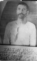
Postcard of Talton Hall, circa 1892
Date
Archival Collection
Description
Image
Howard Hughes standing on the outside steps of City Hall as he poses for pictures in New York City, New York, 1938 July 15
Level of Description
Archival Collection
Archival Component
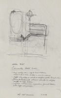
Architectural drawing of Harrah's Marina Hotel Casino (Atlantic City), proposed alterations and rough sketch of the convention hall, July 23, 1982
Date
Archival Collection
Description
Conceptual sketches of Harrah's Atlantic City. Harrah's Marina Hotel Casino later changed its name to Harrah's Resort Atlantic City. Drawn on tissue paper with pencil.
Site Name: Harrah's Marina Resort (Atlantic City)
Address: 777 Harrah's Boulevard, Atlantic City, NJ
Image
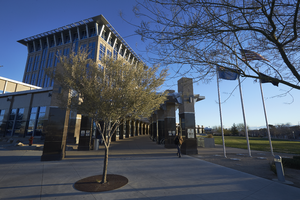
Exterior view of the North Las Vegas City Hall building, looking east-northeast in North Las Vegas, Nevada: digital photograph
Date
Archival Collection
Description
From the UNLV University Libraries Photographs of the Development of the Las Vegas Valley, Nevada (PH-00394). Part of the collection documents the entire 19 mile length of the north/south Eastern Avenue / Civic Center Drive alignment. This photograph was captured in the section of Civic Center Drive between Las Vegas Boulevard and Lake Mead Boulevard.
Image
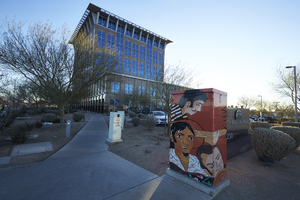
A mural on an electrical box outside of North Las Vegas City Hall, looking east in North Las Vegas, Nevada: digital photograph
Date
Archival Collection
Description
From the UNLV University Libraries Photographs of the Development of the Las Vegas Valley, Nevada (PH-00394). Part of the collection documents the entire 19 mile length of the north/south Eastern Avenue / Civic Center Drive alignment. This photograph was captured in the section of Civic Center Drive between Las Vegas Boulevard and Lake Mead Boulevard.
Image
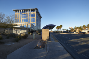
Bus stop in front of the North Las Vegas City Hall building, looking west in North Las Vegas, Nevada: digital photograph
Date
Archival Collection
Description
From the UNLV University Libraries Photographs of the Development of the Las Vegas Valley, Nevada (PH-00394). Part of the collection documents the entire 19 mile length of the north/south Eastern Avenue / Civic Center Drive alignment. This photograph was captured in the section of Civic Center Drive between Las Vegas Boulevard and Lake Mead Boulevard.
Image
Landscaping in front of North Las Vegas City Hall building and Walgreens, looking west in North Las Vegas, Nevada: digital photograph
Date
Archival Collection
Description
From the UNLV University Libraries Photographs of the Development of the Las Vegas Valley, Nevada (PH-00394). Part of the collection documents the entire 19 mile length of the north/south Eastern Avenue / Civic Center Drive alignment. This photograph was captured in the section of Civic Center Drive between Las Vegas Boulevard and Lake Mead Boulevard.
Image

Transcript of interview with Ashley Hall by Claytee White, September 2, 2015
Date
Archival Collection
Description
Ashley Hall was born April 3, 1943 in Caliente, Nevada. After high school, he worked for the Union Pacific Railroad at the Nevada Test Site as a cashier and as a signalman. He later attended Brigham Young University and the University of Nevada, Reno. After college, Hall served the City of Las Vegas in significant ways. Notably, as City Manager he was instrumental in the initial development of Summerlin, Nevada. Though he has retired from local politics, he remains active as the President of the Old Spanish Trail Association and as the U.S. Army Reserve Ambassador.
Text
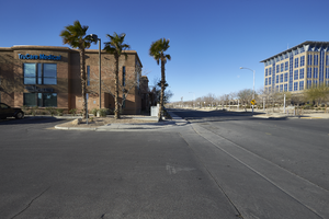
The TruCare Medical building on North McDaniel Street with City Hall, looking west in North Las Vegas, Nevada: digital photograph
Date
Archival Collection
Description
From the UNLV University Libraries Photographs of the Development of the Las Vegas Valley, Nevada (PH-00394). Part of the collection documents the entire 19 mile length of the north/south Eastern Avenue / Civic Center Drive alignment. This photograph was captured in the section of Civic Center Drive between Las Vegas Boulevard and Lake Mead Boulevard.
Image
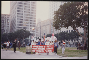
March to Los Angeles: City Hall, Culinary Union, Los Angeles (Calif.), 1992 (folder 1 of 2), image 1
Date
Description
Image