
Search the Special Collections and Archives Portal

Search Results

Display    Results Per Page
Displaying results 59751 - 59760 of 147015

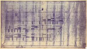
Plat of original townsite of Las Vegas, Clark County, Nevada, November 25, 1927

Date

1927-11-25

Description

Subtitle: 'On N 1/2 of SW 1/4 section 27, T 20 S, R 61 E, M.D. Mer. showing cast iron water mains. Including location and distances of valves, fire hydrants, house connections, etc. Constructed by Las Vegas Land &Water Company. Construction completed Nov. 25-1927. Cast iron pipe system throughout made at Provo, Utah by Pacific States Cast Iron Pipe Company. R.N. Clark, Construction Engineer. Map and survey made by J.T. McWilliams, C.E., Las Vegas, Nev.' Map shows ownership of some parcels of land. Scale [ca. 1:960]. 1 inch to 80 feet. Blueline print. Plat map.

Image

Map of part of North Central New Mexico atlas sheets 69(B), 69(D), 77(B) and 78(A), June 30, 1881

Date

1881-06-30

Description

39 x 52 cm. Relief shown by hachures and spot heights "Issued June 30, 1881." "Expeditions of 1873, 1878 and 1879 under the command of 1st. Lieut. Geo. M. Wheeler, Corps of Engineers U.S. Army." Geological map Probably originally published as part of the geological atlas which is an appendix to the Surveys' Report upon United States geographical surveys west of the one hundredth meridian. "Prof. John J. Stevenson, geological assistant." "By order of the honorable the Secretary of War under the direction of Brig. General A. A. Hunphreys, Chief of Engineers, U. S. Army." Original publisher: U.S. Geographical Surveys West of the 100th Meridian, Scale: 1 inch to 4 miles or 1: 253440.

Image

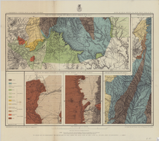
Map of Las Vegas artesian basin, Clark County, Nevada, April 1946 (Water Resources Bulletin no. 5, plate 5)

Date

1946-04

Description

'April, 1946.' 'Showing location of wells, springs, and boundary between valley fill and bedrock.' At top of map: 'United States Department of Interior, Geological Survey. Water resources bulletin no. 5, plate 5. ' 'State Engineer of Nevada.' At bottom of map: 'Map showing soils, land classification, and alkali concentration in part of Las Vegas Valley.' Includes range and township grid. Scale [ca. 1:71,597. 1 in. to approx. 1.13 miles]. Series: Water resources bulletin (Carson City, Nev.), no. 5. Originally published as plate 5 in Geology and water resources of Las Vegas, Pahrump, and Indian Spring Valleys, Clark and Nye Counties, Nevada by George B. Maxey and C.H. Jameson, which is number 5 of the Water resources bulletin published by the Nevada Office of the State Engineer.

Image

Map of part of north central New Mexico, atlas sheet no. 70(C), May 7th, 1877

Date

1877-05-07

Description

39 x 50 cm. Relief shown by hachures and spot heights. "Issued May 7th 1877-2nd ed. June 30th, 1881." "Expeditions of 1878 and 1879 under the command of 1st. Lieut. Geo. M. Wheeler, Corp. of Engineers U.S. Army." "Weyss Herman & Lang Del." Prime meridians: Washington, D.C. and Greenwich Geological map Probably originally published as part of the geological atlas which is an appendix to the Surveys' Report upon United States geographical surveys west of the one hundredth meridian. "Prof. John J. Stevenson, geological assistant." "By order of the honorable the Secretary of War under the direction of Brig. General A. A. Hunphreys, Chief of Engineers, U. S. Army." Original publisher: U.S. Geographical Surveys West of the 100th Meridian, Scale: 1 inch to 4 miles or 1: 253440.

Image

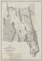
Map of the Great Salt Lake and adjacent country in the territory of Utah, 1850

Date

1849 to 1850

Description

108 x 75 cm. Map part hand colored. Relief shown by hachures and depths shown by soundings. Accompanies U.S. Army. Corps of Topographical Engineers. Exploration and survey of the valley of the Great Salt Lake of Utah. "Map of the Great Salt Lake and adjacent country in the Territory of Utah. Surveyed in 1849 and 1850, under the orders of Col. J. J. Abert, Chief of the Topographical Bureau, by Capt. Howard Stansbury of the Corps of Topographical Engineers, aided by Lieut. J. W. Gunnison Corps Topographical Engineers and Albet Carrington. Drawn by Lieut. Gunnison and Charles Preuss. Ackerman lith 379 Broadway N. Y." Original publisher: Ackerman Lith. Scale: 1:240,000.

Image

Map showing plan for water quality management update for wastewater collection systems in the Las Vegas Valley, February 20, 1997

Date

1997-02-20

Description

'Plate 1. Source: Clark County Geographic Information Systems Central Repository. Comprehensive Planning, Advanced Planning Division. Feburary 20, 1997.' Scale [ca. 1:95, 040. 1 in.=approx. 1.5 miles]. Shows sewers, force mains, service area boundaries, watershed boundaries, and lift stations. Includes inset location map. Includes township and range grid. Clark County, Nevada, Comprehensive Planning, Advanced Planning Division.

Image

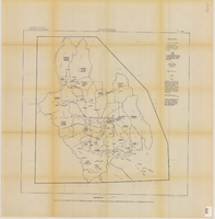
Original plat, townsite of Las Vegas, Lincoln Co., Nevada, January 13, 1905

Date

1905-01-13

Description

Subtitle: 'Embracing the N. 1/2 of S.W. 1/4 Sec. 27 Township 20S. R.61E. Mt. Diablo Meridian.' 'Book 1, page 17A" handwritten in lower right corner. Signed by Henry Lee, County Recorder, Lincoln County Nevada. 'Filed at request of J.T. Williams, January 13th A.D. 1905.' Backwards handwriting on right side. Map has a Lincoln County seal on the bottom near the center. In the dedication J.T. McWilliams states that he has surveyed and platted the townsite of Las Vegas subject to the right of way of the San Pedro, Los Angeles and Salt Lake Railroad Company. He signed the dedication on Jan. 13, 1905, and it was signed by witnesses Scale [ca. 1:2,520? 1 inch to approx. 210 feet?]. Copy of a blueline print.

Image

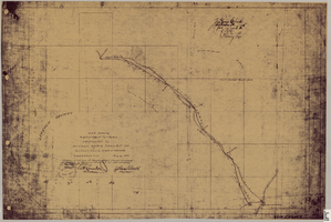
Map showing right of way of toll road constructed by Nevada Rapid Transit Co. in Lincoln County, State of Nevada

Date

1905-08-10

Description

Shows right of way of what now is Interstate 95 through what is now Clark County, Nevada. 'Aug. 10, 1905.' 'Adopted as toll road of Nevada Rapid Transit Company at meeting of Board of Directors of said company Aug. 25th, 1905. Attest W.H. Comstock, secretary, J. Ross Clark, president.' 'Book I, page 3'--Lower right corner. '... No. ... Recorded at ... [signed] J. Ross Clark ... September 1st A.D. 1905 at 40 ... past 8 A.M. to Book of Platts, Pages ... Lincoln Co. Nev. Record ... [signed] Henry Lee ...'--upper right portion of map. Seal of the Nevada Rapid Transit Company in lower left portion of map. Scale [ca. 126,720]. 1 in.=2 miles 1 map. Blueline print.

Image

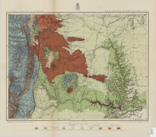
Geologic map and sections of area along Colorado River between Lake Mead and Davis Dam, Arizona and Nevada, 1963

Date

1963

Description

At top of map: 'United States, Department of Interior, Geological Survey. Professional Paper 374-E, plate 1.' In lower right corner of map: 'Geology mapped by C.R. Longwell.' Relief shown by contours. Includes seven colored cross-sections. Scale 1:125,000 (W 114°50´--W 114°20´/N 36°10´--N 35°10´). Series: Shorter contributions to general geology. Professional paper (Geological Survey (U.S.))374-E. Originally published as plate 1 in: Reconnaissance geology between Lake Mead and Davis Dam, Arizona-Nevada / by Chester R. Longwell, published by the U.S. Government Printing Office in 1963 in the series Shorter contributions to general geology and as Geological Survey professional paper 374-E.

Image

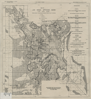
Map showing estimated average recharge to and discharge from ground-water reservoirs by basins, and hydraulic potential in Clark and Nye counties, Nevada, 1963

Date

1963

Description

'T.E. Eakin, S.L. Schoff, and P. Cohen, 1963.' 'Department of the Interior, United States Geological Survey, TEI-833.' 'Prepared in cooperation with the U.S. Atomic Energy Commission.' Scale 1:500,000 (W 117°30´--W 115°00´/N 38°30´--N 36°30´). Originally published as figure 2 in Regional hydrology of a part of southern Nevada : a reconnaissance / by Thomas E. Eakin, Stuart L. Schoff, and Philip Cohen, published by the U.S. Geological Survey in 1963 as number 833 of the Trace elements investigation report.

Image