Search Results
UNLV Libraries Collection of Hollywood Park Inc. Financial Reports and Press Materials
Identifier
Abstract
The UNLV Libraries Collection of Hollywood Park Inc. Financial Reports and Press Materials contains annual reports, financial reports, and press materials from Hollywood Park Incorporated, a gaming and sports entertainment company in Inglewood, California, dating from 1992 to 1999.
Archival Collection
Nevada Association of Psychiatric Physicians Records
Identifier
Abstract
The records of the Nevada Association of Psychiatric Physicians (NAPP) document the professional association's membership, activities, and advocacy from 1984 to 2000. The records indicate how NAPP organized the professional psychiatric community in Southern Nevada, held meetings on various public health initiatives, networked with other professional organizations like the American Medical Association and the American Psychological Association, and published articles and newsletters on a variety of psychiatric topics.
Archival Collection
University of Nevada, Las Vegas Anniversaries Event Records
Identifier
Abstract
The University of Nevada, Las Vegas (UNLV) Anniversaries Event Records (1982 to 2008) are comprised of memorabilia, event planning files, promotional material, and publications that celebrate the university's 25th anniversary in 1982; the 40th anniversary in 1997; and the 50th anniversary in 2007.
Archival Collection
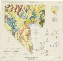
Geologic map of Clark County, Nevada, 1964
Date
Description
Image
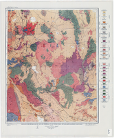
Geologic reconnaissance map of portions of southwestern Nevada and eastern California, 1905
Date
Description
Image
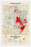
Map showing home-site lands in the Las Vegas Valley, 1955
Date
Description
Image

Topographic map of the northeast quadrangle of the metropolitan Las Vegas, Nevada area, 1967
Date
Description
Image

Topographic map of the northeast quadrangle of the metropolitan Las Vegas, Nevada area, 1973
Date
Description
Image

Topographic map of the northwest quadrangle of the metropolitan Las Vegas, Nevada area, 1967
Date
Description
Image

Topographic map of the northwest quadrangle of the metropolitan Las Vegas, Nevada area, 1973
Date
Description
Image