Search Results
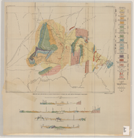
Geologic map and sections of Muddy Mountains, St. Thomas Gap, and part of the Grand Wash Cliffs, 1928
Date
1928
Description
'Geology by C.R. Longwell.' At top of map: 'U.S. Geological Survey Bulletin 798, plate 1.' Includes four colored cross-sections. 1:250,000 (W 115°00'--W 113°45'/N 36°45'--N 36°00'). Series: Bulletin (Geological Survey (U.S.)no. 798. Originally published as plate 1 in: Geology of the Muddy Mountains, Nevada, with a sections through the Virgin Range to the Grand Wash Cliffs, Arizona / by Chester R. Longwell. Washington, D.C. : Government Printing Office, 1928. (Bulletin ((Geological Survey (U.S.)), no. 798).
Image

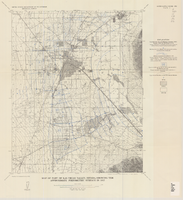
Map of the Las Vegas ground-water basin, Clark, Nye, and Lincoln Counties, Nevada, 1965
Date
1965
Description
At top of map: 'United States Department of the Interior, Geological Survey. Water-supply paper 1780, plate 1.' At bottom of map: 'Base from Army Map Service sheets NJ 11-9, NJ 11-12, and NI 11-3 (1947).' 'Boundary between bedrock and alluvium in Clark County, Nev., compiled by Ben Boyer, E. H. Pampeyan and C. R. Longwell. In Lincoln and Nye Counties, contact determined from aerial photographs.' 'Interior--Geological Survey, Washington, D.C.--1965--W63358.' Includes township and range lines.Relief shown by contours. Thematic map. Scale 1:250,000 (W 116°--W 114°45´/N 37°00´--N 35°30´). Series: Water-supply paper (Washington, D.C.), 1780. Originally published as plate 1 of Available water supply of the Las Vegas ground-water basin, Nevada, by Glenn T. Malmberg, published by the Geological Survey in 1965 as its Water-supply paper 1780.
Image
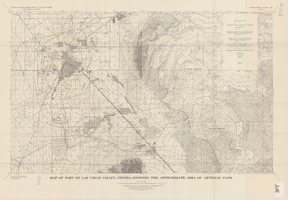
Map of part of Las Vegas Valley, Nevada, showing the approximate area of artesian flow, 1965
Date
1965
Description
At top of map: 'United States Department of the Interior, Geological Survey. Water supply paper 1780, plate 2.' At bottom of map: 'Base from U.S. Geological Survey Las Vegas (1952) and Henderson (1952) quadrangles.' 'Interior--Geological Survey, Washigton, D.C.--1965--W63358.' Relief shown by contours. Includes township and range lines. Thematic map. Scale 1:62,500 (W 115°15´--W 114°45´/N 36°15´--N 36°00´). Series: Water-supply paper (Washington, D.C.)1780. Originally published as plate 2 of Available water supply of the Las Vegas ground-water basin, Nevada, by Glenn T. Malmberg, published by the Geological Survey in 1965 as its Water-supply paper 1780.
Image
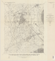
Map of part of Las Vegas Valley, Nevada, showing the approximate piezometric surface in 1912
Date
1965
Description
'Base by U.S. Geological Survey, 1952.' 'Interior--Geological Survey, Washington, D.C.--1965--W63358.' 'Compiled from data published by Carpenter (1915), Kearney (1913), and McWilliams (1913).' Relief shown by contours. Includes township and range lines. Scale 1:62,500 (W 115°15´--W 115°00´/N 36°15´--N 36°00´). Series: Water-supply paper (Washington, D.C.)1780. Originally published as plate 7 of Available water supply of the Las Vegas ground-water basin, Nevada, by Glenn T. Malmberg, published by the Geological Survey in 1965 as its Water-supply paper 1780.
Image
Map of part of Las Vegas Valley, Nevada, showing the approximate altitude of the water table in the near-surface reservoir in February 1956
Date
1965
Description
Genre/Form: Thematic maps. Scale 1:62,500 (W 115°15´--W 115°00´/N 36°15´--N 36°00´). 1 map ; 45 x 36 cm. Series: Water-supply paper (Washington, D.C.) ; 1780. Relief shown by contours. Originally published as plate 8 of Available water supply of the Las Vegas ground-water basin, Nevada, by Glenn T. Malmberg, published by the Geological Survey in 1965 as its Water-supply paper 1780. Includes township and range lines. Interior, Geological Survey
Image

Map of Las Vegas, Nevada and surrounding Bureau of Land Management areas to the west and north, 1994
Date
1994
Description
'BLM edition, 1994.' 'Surface management status; mineral management status.' '1:100,000-scale topographic map showing highways, roads and other manmade structures; water features; contours and elevations in meters with conversions to feet; BLM recreation sites.' 'Edited and published by the Bureau of Land Management. Base map prepared by the U.S. Geological Survey.' I53:11/4-2
Text

Official Arrow city map, Las Vegas & vicinity, Nevada, circa 1957-1961
Date
1957 to 1961
Description
71 x 68 cm. on sheet 106 x 71 cm., folded in cover 25 x 12 cm. Cover title: Latest edition, city map and street index of "fabulous" Las Vegas and vicinity, Nevada. Publisher from cover. "H-654-32." Includes indexes. Inside of cover includes information on Las Vegas. Includes inset maps of Boulder City, Nevada, and Las Vegas's location. Original publisher: R. L. Polk.
Image

Geologic map of the Paiute Ridge quadrangle, Nye and Lincoln Counties, Nevada, 1967
Date
1967
Description
58 x 46 cm., on sheet 85 x 83 cm., fold. in envelope 30 x 24 cm. Relief shown by contours and spot heights. "Contour interval 20 feet." "Prepared in cooperation with the U.S. Atomic Energy Commission." "Geology mapped in 1961. Contours on pre-Tertiary rocks by D. L. Healey and C. H. Miller, 1963." Includes text, 4 col. cross sections, and quadrangle location map. Original publisher: U. S. Geological Survey, Series: Geologic quadrangle map GQ, Scale: 1:24 000.
Image

Geologic map of the Lathrop Wells quadrangle, Nye County, Nevada, 1970
Date
1970
Description
58 x 47 cm., on sheet 74 x 84 cm., folded in envelope 30 x 24 cm. Relief shown by contours and spot heights. "Bedrock geology mapped by B.C. Burchfiel, 1961, and by E.J. McKay and K.A. Sargent, 1965-66. Surficial geology mapped by A.T. Fernald, 1968." Includes cross sections, description of map units, and location map. "Prepared in cooperation with the U. S. Atomic Commission." Original publisher: Interior, Geological Survey, Series: Geologic quadrangle map GQ, Scale: 1:24 000.
Image

Geologic map of the Dead Horse Flat quadrangle, Nye County, Nevada, 1967
Date
1967
Description
58 x 46 cm., on sheet 77 x 84 cm., folded in envelope 30 x 24 cm. Relief shown by contours and spot heights. "Base by U.S. Geological Survey, 1960." "Geology mapped in 1962-64." "Contour interval 20 feet." Includes 2 col. cross sections, quadrangle location map, and text. "Prepared in cooperation with the U. S. Atomic Commission." Original publisher: Interior, Geological Survey, Series: Geologic quadrangle map GQ, Scale: 1:24 000.
Image