Search Results
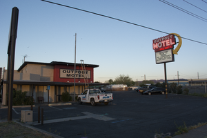
Photographs of Outpost Motel, Las Vegas (Nev.), March 14, 2017
Date
2017-03-14
2017-08-28
Archival Collection
Description
The Outpost Motel sign sits at 1104 North Boulder Highway. Information about the sign is available in the Southern Nevada Neon Survey Data Sheet.
Site name: Outpost Motel (Las Vegas, Nev.)
Site address: 1104 N Boulder Hwy
Sign owner: Vegas Outpost Motel LLC
Sign details: The Outpost motel was built all the way back in 1937 and still resides out in Henderson along Boulder Highway. The current sign was installed around the 1950's.
Sign condition: 5, the sign is in excellent condition.
Sign form: Pole
Sign-specific description: This pole sign has a zig-zag like design on the top of it. Underneath that is the word "OUTPOST" in bold white letters against a forest green background. "MOTEL" is painted under that in bold white letters as well. "VACANCY" is painted under the "OTEL." Outlined in neon is "NO," which is difficult to see if it's not lit up. Each of these words is outlined with neon as well so you can see them at night when the sign would be lit up. The lower half of the sign is a back lit reader board. On the outer edge of the sign is a large, yellow arrow that extends from the top of the sign above the "O" in "OUTPOST" and points to the reader board. This is also covered in incandescent light bulbs.
Sign - type of display: Neon, incandescent, backlit reader board
Sign - media: Steel and plastic
Sign - non-neon treatments: Reader board
Sign animation: From photos, it looks as though the sign has some sort of animation to it in the yellow arrow on the outer edge. The incandescent light bulbs look as though they twinkled, but it is difficult to tell exactly how or in what direction.
Sign environment: This property sits way out in Henderson along Boulder Highway. It is down the street from Sam Boyd Stadium, Clark County Wetlands Park, and the Henderson Bird viewing Preserve. The properties that sit immediately next to the motel are a few small casinos and a random assortment of businesses.
Sign - date of installation: Possibly the 1950's
Sign - date of redesign/move: Photos from 2014 show that the sign was in a rough condition at one point, but in 2015 it received a fresh coat of paint.
Sign - thematic influences: The design for this sign is similar to many of the small motel throughout the city from the 1950's/60's era. They usually have one major element that makes them striking when viewed from the street view, for this sign it would be the big, yellow arrow. It is also a pole sign and many of the motels from this time period use this style of sign.
Survey - research locations: Roadside architecture http://www.roadarch.com/signs/nv2.html , Classic Las Vegas website ghhhttp://classiclasvegas.squarespace.com/classic-las-vegas-photo-galler/classic-las-vegas-signs/900788 , Asessor's Page http://www.clarkcountynv.gov/assessor/Pages/searchbybusinessname.aspx , Flickr website for photos https://www.flickr.com/photos/roadsidepictures/294981090
Survey - research notes: There are not many sources discussing the history of this property.
Surveyor: Lauren Vaccaro
Survey - date completed: 2017-08-28
Sign keywords: Neon; Incandescent; Backlit; Steel; Plastic; Reader board; Pole sign; Directional
Mixed Content
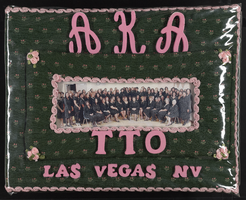
Alpha Kappa Alpha Sorority, Theta Theta Omega Chapter scrapbook
Date
2008 to 2009
Archival Collection
Description
From the Alpha Kappa Alpha Sorority, Incorporated, Theta Theta Omega Chapter Records (MS-01014).
Mixed Content
Foley, Roger Drummond, 1917-1996
Roger Drummond Foley (1917-1996) was Nevada’s 23rd Attorney General and was nominated to the federal United States District Court, District of Nevada by President John F. Kennedy in 1962. A few of Foley’s famous cases during his tenure included the radiation exposure of the “Baneberry” Nuclear Test and the protection of the Ash Meadows Desert Pupfish in United States v. Francis Leo Cappaert.
Person
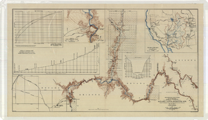
Topographic map of the Boulder Canyon Reservoir site, 1930
Date
1930
Description
Scale [ca. 1:144,000. 1 in. to approx. 12,000 ft.] ; 1 map : col. ; 51 x 91 cm ; Relief shown by contours and spot heights ; "Map no. 23800" ; Includes township and range grid ; Includes two profile diagrams, area and capacity curve diagram, Topography of Black Canyon and vicinity map and Colorado River basin map. Inset maps of Black Canyon and vicinity and Colorado River Basin. Inset charts of Boulder Canyon Reservoir Area and Capacity Curves; and, Profile of Colorado River from Bridge Canyon Dam Site, Arizona to Black Canyon Dam Site, Arizona-Nevada. Bureau of Reclamation.
Image
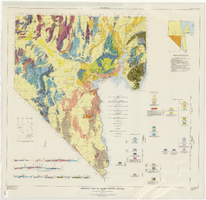
Geologic map of Clark County, Nevada, 1964
Date
1964
Description
'By C.R. Longwell, E.H. Pampeyan, and Ben Bowyer.' 'Prepared cooperatively by the U.S. Geological Survey.' 'Topographic base from Army Map Service Kingman (1947) and Las Vegas (1953) two-degree quadrangle. More recent editions were published after geological compilation and are used on Plate 2.' 'Geology compiled 1955 with revisions and additons to 1964.' At top of map: 'Nevada Bureau of Mines. Bulletin 62, Plate 1.' Published by Williams & Heintz Map Corp. Scale 1:250,000. Bulletin (Nevada Bureau of Mines)
62. Relief shown by contours and spot heights. Includes two index maps and eight cross-sections.
62. Relief shown by contours and spot heights. Includes two index maps and eight cross-sections.
Image
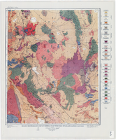
Geologic reconnaissance map of portions of southwestern Nevada and eastern California, 1905
Date
1905
Description
At top of map: 'U.S. Geological Survey, Charles D. Walcott, director.' At bottom of map: 'E.M. Douglas, Geographer. R.H. Chapman, in charge of section.Triangulation and topography by R.H. Chapman and B.D. Stewart. Surveyed in 1905.' 'Geology by Sydney H. Ball. Geology in immediate vicinity of Goldfield and Bullfrog generalized from maps by F.L. Ransome assisted by George H. Garrey and W.H. Emmons.' Scale 1:250,000 (W 117°30--W 116°/N 38°--N 36°)
Image
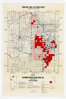
Map showing home-site lands in the Las Vegas Valley, 1955
Date
1955
Description
Scale [1:84,269. 1 in. to 1 1/3 miles] ; 1 map : col. ; 57 x 50 cm. on sheet 89 x 59 cm ; Cadastral map ; Gives definition of township, section and acre ; Relief shown by form lines and spot heights ; Shows private land, land classified for small tracts, leased land, vacant Federal land, section numbers, number of acres in each homesite and purchase price of tract ; "From your Congressman Cliff Young."--stamped on map ; Southern Nevada Home-Siters
Image

Topographic map of the northeast quadrangle of the metropolitan Las Vegas, Nevada area, 1967
Date
1967
Description
Scale 1:24,000 ; polyconic proj. (W 115°730--W 115°0000/N 36°1500--N 36°730) ; 1 map : col. ; 58 x 47 cm ; 7.5 minute series (topographic) ; Relief shown by contours and spot heights ; Filing title: Las Vegas NE, Nev ; "AMS 2956 II NE--Series V896." ; Contour interval 20 feet ; "Topography by photogrammetric methods from aerial photographs taken 1965. Field checked 1967." ;Includes quadrangle location map ; Interior--Geological Survey
Image

Topographic map of the northeast quadrangle of the metropolitan Las Vegas, Nevada area, 1973
Date
1973
Description
Scale 1:24,000 ; polyconic proj. (W 115°730--W 115°0000/N 36°1500--N 36°730) ; 1 map : col. ; 58 x 47 cm ; 7.5 minute series (topographic) ; Relief shown by contours and spot heights ; "AMS 2956 II NE--Series V896." ; Contour interval 20 feet ; "Topography by photogrammetric methods from aerial photographs taken 1965. Field checked 1967." ; "Revisions shown in purple compiled from aerial photographs taken 1973. This information not field checked." ; Includes quadrangle location map ; Filing title: Las Vegas, NE, Nev ; Interior--Geological Survey
Image