Search Results
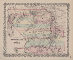
Map of territories of New Mexico and Utah, 1855
Date
1855
Description
29 x 36 cm. Shows natural features, and populated places, wagon route, proposed railroad routes and explorers' routes. Relief shown by hachures. Prime meridians: Greenwich and Washington. "Entered according to act of Congress in the year 1855 by J.H. Colton & Co in the Clerk's Office of the District Court of the U.S. for the Southern District of New York." Hand colored. Atlas p. number in lower-right margin: 51. Decorative border. The geographic region of Southwest is referred to as the New Southwest. Original publisher: J.H. Colton .
Image

Map of California, with territories of Utah, Nevada, Colorado, New Mexico, and Arizona, 1864
Date
1864
Description
40 x 62 cm. Relief shown by hachures. Prime meridians: Greenwich and Washington. Page numbers at top: 58-59. "Entered according to act of Congress in the year 1864 by A. J. Johnson in the Clerk's Office of the District Court of the United States for the Southern District of New York." Original publisher: Johnson and Ward.
Image
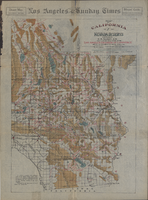
Map of California and Nevada deserts, 1905
Date
1905
Description
'Compiled by G.E. Bailey, E.M. Issued under the auspices of the the Los Angeles Chamber of Commerce and the supervision of its mining committee, Dan Murphy, H.Z. Osborne, Geo. W. Parsons, F.W. Braun, O.P. Posey, 1905.' 'A carefully prepared and authentic map of the desert mining region tributary of Los Angeles, embracing portions of Lincoln, Nye and Esmeralda counties, Nevada, showing location of all water supplies.' At top of page: 'Desert map. California-Nevada'. 'Miner's guide. Springs and waterholes.' Relief shown by hachures. Shows range and township grid. Scale indeterminable (W 119°--W 114°/N 37°--N 33°).
Image
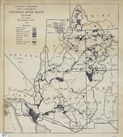
Map of Colorado River Basin, 1928
Date
1928
Description
52 x 46 cm. "Map no. 23000." Shows reservoir sites, irrigated areas, power plants, power sites, dam sites, national parks or monuments, and diversion from basin. Colorado River Basin/Department of the Interior, Bureau of Reclamation; John H. Pellen, chief draftsman. Original publisher: United States. Bureau of Reclamation.
Image
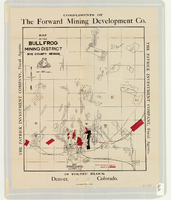
Map of the Bullfrog Mining District, Nye County, Nevada, circa 1905
Date
1901 to 1909
Description
At top of map: 'Compliments of the Forward Mining Development Co.' On left and right margins: 'The Patrick Investment Company, Fiscal Agents.' At bottom of map: '19 Toltec Block, Denver, Colorado.' 'The Williamson-Haffner Co., Denver.' Relief shown by hachures. Properties owned by Patrick Investment Company are marked in red. Shows railroads, roads, and pipelines. Scale [ca. 1:39,000. 1 in. to approx. 3,250 feet].
Image
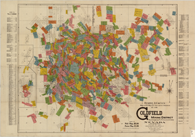
Map of U.S. patent and location surveys in the Goldfield Mining District, Esmeralda and Nye Counties, Nevada, 1907
Date
1907
Description
'Elmer J. Chute, E.M. and Olmstead & Rich. U.S. Deputy Mineral Surveyors, 1907. Copyright 1907 by Elmer J. Chute, E.M., Goldfield, Nev.' Includes index Includes township and range grid. Scale [ca. 1:22,800. 1 in. to approx. 1900 feet]
Text

Map of Argentite Red Mountain Mining District, Esmeralda County, Nevada, circa 1908-1913
Date
1908 to 1913
Description
'Compiled by C. A. Liddell, U.S. Mineral Surveyor, Tonopah, Nevada, from surveys by Sherwin, Giles and Liddell.' Published between 1908-1913? Scale [ca. 1:7,200]. 1 in. equals 600 feet. Map printed on linen.
Image
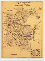
Map of Searchlight mining district, Clark County, Nevada, circa 1905
Date
1901 to 1909
Description
At bottom right of map: 'C.D. Baker, A.R. Thompson.' Title in lower right corner: 'Map of Searchlight mining district: mineral patents, water rights.' Logo of Nevada Engineering Construction Service, Inc., Las Vegas, Nev. in lower right corner. Blueline print. Shows mineral patents and water rights. Nevada Engineering & Construction Service, Inc.
Image
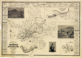
Map of Tonopah Mining District, Nye County, Nevada, 1902
Date
1902
Description
'Compiled and published by Booker & Bradford, engineers, Tonopah, Nevada.' 'Copyrighted by Booker & Bradford 1902.' 'Lith. Britton & Rey, S.F., Cal.' Relief shown by hachures. Includes insets of Ray Mining District, Nye County, Nevada, and Vicinity map of Tonopah Mining District, Nye County, Nevada. Includes advertisements and photographs of Tonopah ore, town of Tonopah, and of J.L. Butler, discoverer of the Mizpah Lode. Scale [ca. 1:7,200]. 1 inch to 600 feet. Mounted on linen.
Text
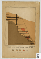
Vertical cross-section of Eureka Consolidated Mine, 1883
Date
1883
Description
'G. F. Becker, geologist-in-charge. Julius Bien & Co. lith. Mapping and geology by J. S. Curtis.' 'U.S. Geological Survey. Annual report 1883, pl. XXXIII.' Published by U.S. Geological Survey. Scale [ca. 1:2,400] 1 in.=200 feet. Library's copy has "Nev." printed in pencil in upper right corner.
Image