
Search the Special Collections and Archives Portal

Search Results

Display    Results Per Page
Displaying results 23841 - 23850 of 24328

Transcript of meeting regarding the Las Vegas Valley Water District, held under the auspices of Las Vegas Chamber of Commerce, October 1, 1948

Date

1948-10-01

Archival Collection

Description

Transcript of a meeting to discuss the creation of the Las Vegas Valley Water District

Text

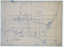
Map showing location of 24" C.I. pipeline in Las Vegas, Nevada, circa 1943

Date

1941 to 1945

Description

Scale [ca. 1:120]. 1 in. to 10 feet.--Scale [ca. 1:1,200.] 1 in. to 100 feet.--Scale [ca. 1:7,200. 1 in.=approx. 600 feet] --Scale [ca. 1:7,200]. 1 in.=600 feet. Vertical scale [ca. 1:240]. 1 in.=20 feet. 1 map : blueline ; 58 x 74 cm. At head of title: As constructed drawing. "W.O.-8577." "Drawing no. 41092." "City of Las Vegas Highway transcribed from drwg. approved Harlan Brown, City Engineer-Sept. 1943-H.D.A 12/31/43"--Hand-written note. Map of the water pipes for Las Vegas. Includes the buildings in the railroad yard, a detailed map of a section of the pipe, a profile of the 24 inch C.I. pipe, and a map of the point of diversion. Date of detailed map is 5-20-1930. From the Union Pacific Railroad Collection. Los Angeles & Salt Lake Railroad Company, Office of Chief Engineer

Image

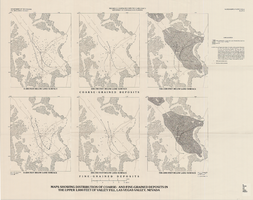
Maps showing distribution of coarse- and fine-grained deposits in the upper 1,000 feet of valley fill, Las Vegas Valley, Nevada, 1981 (Water-supply paper 2320-A, plate 3)

Date

1981

Description

'Department of Interior, U.S. Geological Survey. Water-supply paper 2320-A, plate 3.' 'Prepared in cooperation with the Clark County Department of Comprehensive Planning.' 'Base from U.S. Geological Survey, 1:250,000, Las Vegas and Kingman, 1969.' 'Geology from Malmberg (1965); Longwell and others (1965); and J. R. Harrill, 1976. Lithology by R.W. Plume, 1981.' Contents: Coarse-grained deposits: 0-200 feet below land surface; 200-700 feet below land surface; 700-1,000 feet below land surface -- Fine-grained deposits: 0-200 feet below land surface; 200-700 feet below land surface; 700-1,000 feet below land surface. Scale [ca. 1:316,800. 1 in.=approx. 5 miles]. Series: U.S. Geological Survey water-supply paper2320-A. Originally published as plate 3 of Ground-water conditions in Las Vegas Valley, Clark County, Nevada. Part I. Hydrogeologic framework / by Russell W. Plume, published by the U.S. Geological Survey in 1989 as Water-supply paper 2320-A.United States Dept. of the Interior, Geological Survey.

Image

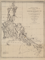
Map of explorations and surveys south of the Central Pacific Railroad made by the U.S. Army Corps of Topographical Engineers, 1871

Date

1871

Description

'Preliminary topographical map embracing in skeleton a portion only of the notes from surveys made in accordance with Par.II Special Orders No. 109 War Dept., March 18th, 1871 and letter of instructions of Brig. General A.A. Humphreys, Chief of Eng'rs. dated March 23rd, 1871. Conducted under the immediate direction of 1st Lieutenant Geo. M. Wheeler, Corps of Eng'rs., assisted by 1st Lieutenant D.W. Lockwood, Corps of Eng'rs. and 2nd Lieutentant D.A. Lyle, 2nd U.S. Artillery, during the summer and fall of 1871. Louis Nell, chief topographer and draughtsman.'' At head of map: 'Explorations in Nevada and Arizona. U.S. Engineer Department.' In lower left corner: 'Note: This map is a hasty and partial compilation from the topographical data already received, many still remaining en route. Upon it is projected in skeleton the groundwork of the area examined. All points except the prominent astronomical positiions are subject to lsight modification upon the final map.' Shows area through central Nevada, eastern California, and central Arizona. Relief shown by hachures. Published by the War Dept. Scale [ca. 1:1,520,640]. 1 in. to 24 miles (W 118°--W 109°/N 41°--N 32°).

Image

Map showing detailed topography of the country traversed by the reconnaissance expedition through southern & southeastern Nevada, 1869 (reproduction)

Date

1869

Description

At top of map: 'Reconnaissance Maps, Department of California.' 'In charge of, Lieut. Geo. M. Wheeler, U.S. Engineers; assisted by Lieut. D.W. Lockwood, Corps of Engineers,U.S.A., 1969.' 'P.W. Hamel, chief topographer and draugthsman.' 'Traced 11-13-67.' 'BGS'; the G is enclosed in an arrowhead shape. 'Officially compiled and published at the Engineer Office, Head Quarters Department of California in 1869 and 70 by order of Brigadier General E.O.C. Ord. Comm'dg. [signed] Geo. M. Wheeler, Lieutenant of Engineers In Charge, Head Quarters Dept. of Cal. Oct. 26th, 1870.' Includes information from railroad maps, the United States Geological Survey of the 40th parallel and from Lieutenant Ives' explorations along the Colorado. Map includes camps, astronomical stations, good and bad wagon roads, trails, springs, settlements, mining districts, state and county boundaries and the watershed between the Humboldt and Colorado Basin. Shows most of eastern half of Nevada. Relief shown by hachures and spot heights. Scale indeterminable. (W 117°00´--W 113°00´/N 41°45´--N 35°45´). Series: Reconnaissance maps. Military map / Department of Californiano. 1. Reproduction. Map is printed in purple. Scale of original map: [1:760,320]. 1 in. to approx. 12 miles. Includes dots hand-colored with red pencil marking Indian rancherias.

Image

Mike Miller Papers

Identifier

MS-00715

Abstract

The Mike Miller Papers (1971-2014) include advertisements, books, and paintings by Las Vegas, Nevada-based artist and graphic designer Mike Miller. Materials include photographs, art prints, advertisements, newspaper clippings featuring Miller's advertisements, casino advertisements, and books designed, written, or illustrated by Miller.

Archival Collection

Stan Armstrong Photograph Collection [DEACCESSIONED]

Identifier

PH-00371

Abstract

[DEACCESSIONED] Collection is comprised of personal and community photos collected by Stan Armstrong dating from the 1940s to the 2000s. The collection also consists of photos of the historic Westside neighborhood of Las Vegas, Nevada and its African American community. Also included are promotional posters from Stan Armstrong's documentaries and memorial service programs of members of the African American Community.

Archival Collection

David Coons Photograph Collection

Identifier

PH-00029

Abstract

The David Coons Photograph Collection contains photographs and postcards depicting railroads in Nevada, California, and Utah from 1907 to 1956. The photographs depict trains and locomotives from the Tonopah & Tidewater Railroad, Union Pacific Railroad, San Pedro, Los Angeles & Salt Lake City Railroad, Bullfrog-Goldfield Railroad, Las Vegas & Tonopah Railroad, and Tonopah & Goldfield Railroad. The photographs also portray Arden, Nevada and the Arden Plaster Company Plant, Las Vegas High School after a fire, and early Fremont Street in Las Vegas, Nevada.

Archival Collection

Nevada Historical Society Photograph Collection

Identifier

PH-00033

Abstract

The Nevada Historical Society Photograph Collection contains photographs of Nevada from 1873 to 1951. The photographs primarily depict the towns of Pioche, Candelaria, and Tonopah in the early-twentieth century. The photographs also depict Nevada Governor Emmett D. Boyle and U.S. Senators William M. Stewart and Key Pittman. The collection contains two images related to the Women's Suffrage movement, including Governor Boyle signing a resolution in favor of the Nineteenth Amendment to the U.S. Constitution and Anne Martin's campaign for the U.S. Senate in 1918. Lastly, the photographs also depict mining operations in Bullionville and Candelaria.

Archival Collection