Search Results

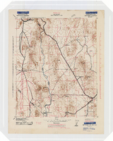
Topographic map of the Camp Mohave quadrangle in California, Nevada and Arizona, 1942
Date
1942
Description
Scale 1;250,000 ; polyconic projection (W 115°--W 114V/N 36V--N 35V) ; 1 map : col. ; 52 x 37 cm ; Relief shown by contours and spot heights. Contour interval 250 feet ; "Training map"--Center of upper margin of map ; "Base compiled from U.S. Geological Survey quadrangles. Control from U.S. Geological Survey. Revised from state highway maps for Arizona, Nevada and California" ; "Culture revisions shown in red based on reconnaissance by 67th Engr. Co. (Top.). May not be of same accuracy as base map." ; Map shows roads, trails, ponton sites, dam sites, possible air fields, possible landing fields, airports, water points, and impassable areas ; Map was originally restricted. "Classification cancelled by authority of Chief of Engineers letter of Jan. 22, 1946." ; Title at top of map: Nevada-Arizona-California : Camp Mohave quadrangle : grid zone F ; Army Map Service, U.S. Army.
Image
General Documents, 1946-2002
Level of Description
Series
Scope and Contents
The General Documents files contain manuals, questionnaires, membership rosters, advocacy efforts, handbooks, correspondence, news articles, various brochures and articles on the history of the Junior League, documents on the application for membership of the Junior Leagues of America, photographs and project documents.
Archival Collection
Junior League of Las Vegas Records
Archival Component