
Search the Special Collections and Archives Portal

Search Results

Display    Results Per Page
Displaying results 59441 - 59450 of 145718

Map showing configuration of potentiometric surfaces in Paleozoic and Cenozoic aquifers in the area between the Las Vegas Valley and the Amargosa Desert, Nevada, 1963

Date

1963

Description

'Department of the Interior, United States Geological Survey. TEI-840.' 'Prepared in cooperation with the U.S. Atomic Energy Commission.' 'Contours in northwest Las Vegas Valley from Malmberg, 1961.' Relief shown by contours. Shows township and range lines. Scale [ca. 1:253,440. 1 in.=aprrox. 4 miles] (W 114°00´--W 115°00´--N 37°00´/N 36°00´). Originally published in A summary of the ground-water hydrology of the area between the Las Vegas Valley and the Amargosa Desert, Nevada : with special reference to the effects of possible new withdrawals of ground water / by Isaac J. Winograd, published by the U.S. Geological Survey in 1963 as number 840 of the Trace elements investigations report.

Image

Surficial geologic map of Las Vegas Valley, Nevada, circa 1981

Date

1977 to 1985

Description

'United States Department of the Interior, Geological Survey. Open-file report, 84-130, plate 1.' 'Prepared in cooperation with the Clark County Department of Comprehensive Planning.' 'Base from U.S. Geological Survey 1:100,000, Boulder City, Ariz.-Nev., Las Vegas, Nev.-Calif., Mesquite Lake, Nev.-Calif., 1978, Lake Mead, Nev.-Ariz., 1979.'Geology from Malmberg (1965); Longwell and others (1965); Haynes (1967); Bingler (1977); Bell and Smith (1980); Bell (1981); Matti and Bachhuber (1982); and Matti and Morton (1982a and b); modified by R. W. Plume, 1981.' Shows township and range lines. Scale [ca. 1:102,960. 1 in.=approx. 1.625 miles] (W 115°30´--W 115°00´/N 36°30´--N 36°00´). Series: Open-file report (Geological Survey (U.S.))84-130. Originally published as plate 1 of Ground-water conditions in Las Vegas Valley, Clark County, Nevada. Part I. Hydrogeologic framework / by Russell W. Plume, published by the U.S. Geological Survey in 1984 as Open-file report 84-130.

Image

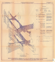
Fence diagram showing lithology of valley-fill deposits and summary of water-bearing properties for valley-fill and bedrock units, Las Vegas Valley, Nevada, 1981 (Open-file report 84-130)

Date

1981

Description

'United States Department of the Interior, Geological Survey. Open-file report 84-130, plate 2.' 'Prepared in cooperation with the Clark County Department of Comprehensive Planning.' 'Geology by R.W. Plume, 1981.' Scale [ca. 1:31,680. 1 in.=approx. .5 miles]. . Series: Open-file report (Geological Survey (U.S.))84-130. Originally published as plate 2 of Ground-water conditions in Las Vegas .Valley, Clark County, Nevada. Part I. Hydrogeologic framework / by Russell W. Plume, published by the U.S. Geological Survey in 1984 as Open-file report 84-130. "Prepared in cooperation with the Clark County Department of Comprehensive Planning."

Text

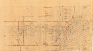
Map of Las Vegas showing areas owned by the Union Pacific Railroad Company, water pipes and other water utilities, circa 1942

Date

1938 to 1946

Description

Map showing downtown Las Vegas and tracts to the west showing water supply lines, wells, springs, and settling basins. Various areas outlined in red and yellow. Scale [ca. 1:7,200] 1 in.=600 feet. Cadastral map. Blueline print. Areas owned by railroad outlined by hand in different colored markers. Library's copy includes hand-written calculations.

Image

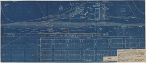
Blueprint map showing proposed water pipeline from Big Spring to Las Vegas, Nevada, January 24, 1911

Date

1911-01-24

Description

'S.P.L.A.&S.L.R.R. Los Angeles Division. Map of pipe line from Big Spring. Las Vegas, Nev. Approved: Jan. 24, 1911. E.M. Jessup, E.M. of W.' In lower right corner: '4-U-323.' Scale [ca. 1:2,400] 1 in.=200 feet. Relief shown by contours. North is to upper right.

Image

Map to accompany joint letter dated April 20th, 1931 to Mr. Gray concerning construction of proposed water main to serve lessees in Industrial Unit No. 1, Las Vegas, Nevada, April 20, 1931

Date

1931-04-20

Description

'Union Pacific System. Los Angeles & Salt Lake Railraod Company.' 'Office of Industrial Engr., Los Angeles, California, April 20th, 1931. Dwg. No. 588.' Scale: 1" = 200'.

Image

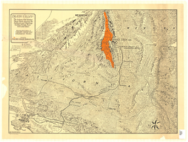
Map of Death Valley and surrounding areas in southern California, southern Nevada and Arizona, 1930

Date

1930

Archival Collection

Description

Col. ; 51 x 69 cm. Oblique perspective map. Relief shown by landform drawings and spot heights. North is toward upper-right corner. "1M--10-33--1846--A.P.Co." printed in lower left corner. Published by the Pacific Coast Borax Company, Los Angeles, California, 1930. Signed by Howard Burke near lower right corner.

Image

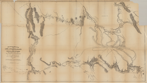
Map based on reconnaissance of the Zuñi, Little Colorado and Colorado Rivers in 1851 by U.S. Corps of Topographical Engineers

Date

1852

Description

Transcribed from the original: 'Made in 1851 under the direction of Col J.J. Abert, Chief of Corps Topographical Engineers, by BVT. Capt. L. Sitgreaves, T.E., assisted by Lieut. J.G. Parke, T.E., and Mr. M.H. Kern. Drawn by R.H. Kern, 1852.' 'Gila River from a reconnaissance by Maj. Emory, Topographical Engrs. Colorado River below Camp Yuma from a reconnaissance by Lt. Derby Topographical Engrs.' Shows Indian villages and forts. Upper right corner partially missing. Scale [ca. 1:650,000]. Scale of 10 miles to one inch.' 'Ackerman Lith.: 379 Broadway, N.Y.'

Image

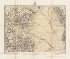
Map of part of south western Colorado, January 10, 1878

Date

1878-01-10

Description

38 x 49 cm. Relief shown by hachures and spot heights. "Atlas sheet no. 61(D)." "Issued Jan. 10th 1878." "Expeditions of 1873, 74, 75 & 76 under the command of 1st. Lieut. Geo. M. Wheeler, Corps of Engineers, U.S. Army." Prime meridians: Washington, D.C. and Greenwich. Includes sectional diagram showing how atlas sheets fit together. "Weyss, Lang & Herman, del." "By order of the honorable the Secretary of War." "Under the direction of Brig. General A. A. Hunphreys, Chief of Engineers, U. S. Army." " J. C. Spiller, Louis Nell, topographical assistants." "Expeditions of 1873, 74, 75 & 76 under the command of 1st. Lieutenant William L. Marshall, Corps of Engineers, U. S. Army, 1st Lieutenant Eric Bergland, Corps of Engineers, U. S. Army, Executive Officers and field astronomers." Original publisher: U.S. Geographical Surveys West of the 100th Meridian, Scale 1 inch to 4 miles or 1:253440.

Image

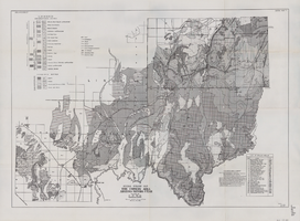
General geologic map of the Corners area, Arizona-Nevada-Utah, April 15, 1952

Date

1952-04-15

Description

46 x 65 cm. "IAPG guide book #7. General plate #1." "April 15, 1952." Includes bibliographic references and index of drilled wells Includes township and range grid. "Drawn by Oscar Baide, Jack Harde." "Compiled by I.A.P.G. under direction of L.F. Wells." Original publisher: I.A.P.G..

Image