Search Results
Nevada Law School Liaison Committee report and Law School Advisory Board correspondence
Date
Archival Collection
Description
Folder contains a report from the Liaison Committee with the Nevada Legislative Commission on the Nevada Law School, and Law School Advisory Board correspondence. From the University of Nevada, Las Vegas William S. Boyd School of Law Records (UA-00048).
Text
Northern Nevada Neon Photograph Collection
Identifier
Abstract
The Northern Nevada Neon Photograph Collection (1913-2010) is comprised of photographs of neon signs located mainly in northern Nevada cities and towns, including Elko, Ely, Carson City, Hawthorne, Reno, and Winnemucca. The collection consists of both digitized and born-digital photographs from multiple institutions and were gathered as part of a joint grant project.
Archival Collection
Gregory, Matt, 1921-2000
Las Vegas, Nevada producer, manager, and agent Matthias Gregory Gluchowski (a.k.a. Matt Gregory) was born November 21, 1921 in Araucaria, Parana, Brazil. He was the son of an aristocratic Polish diplomat serving as Ambassador to Brazil. Matthias was raised in southern Poland on a large estate that bordered Czechoslovakia. He was educated at the Marian Fathers Lyceum in Warsaw, Poland, and later came to New York during his father's tenure as diplomat to the United States.
Person

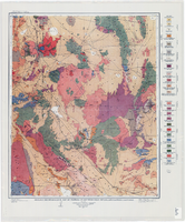
Geologic map of Clark County, Nevada, 1964
Date
Description
Image
Geologic reconnaissance map of portions of southwestern Nevada and eastern California, 1905
Date
Description
Image
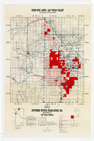
Map showing home-site lands in the Las Vegas Valley, 1955
Date
Description
Image

Topographic map of the northeast quadrangle of the metropolitan Las Vegas, Nevada area, 1967
Date
Description
Image

Topographic map of the northeast quadrangle of the metropolitan Las Vegas, Nevada area, 1973
Date
Description
Image

Topographic map of the northwest quadrangle of the metropolitan Las Vegas, Nevada area, 1967
Date
Description
Image

Topographic map of the northwest quadrangle of the metropolitan Las Vegas, Nevada area, 1973
Date
Description
Image