Search Results
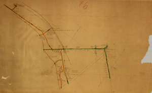
Map of the third level of the Clermont Mine, Goldfield, Nevada, circa 1902-1908
Date
1902 to 1908
Description
Hand-drawn, hand-colored and annotated map showing the third level of the Clermont Mine. 'Clermont, 3rd level, el. 5361.3.'
Image
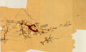
Map of the fourth level of the Clermont Mine, Goldfield, Nevada, circa 1902-1908
Date
1902 to 1908
Description
Hand-drawn, hand-colored and annotated map showing the fourth level of the Clermont Mine. Upper left and lower right corners missing.
Image
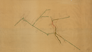
Map of the sixth level of the Clermont Mine, Goldfield, Nevada, circa 1902-1908
Date
1902 to 1908
Description
Hand-drawn, hand-colored and annotated map showing the sixth level of the Claremont Mine. 'Clermont, 6th level, el. 4971.4.'
Image
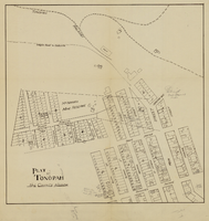
Plat of Tonopah, Nye County, Nevada, circa 1905
Date
1903 to 1907
Description
Plat of properties in downtown Tonopah, Nevada. Notes handwritten in pencil. Southern Nevada Mining Map Collection
Image

Map of underground workings in Potosi and Central Lodes, May 1906
Date
1906-05
Description
'Scale 20 ft = 1 in.'
Image
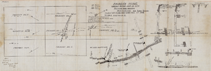
Fairday Mine property map, May 25, 1916
Date
1916-05-25
Description
'Fairday Mine, Cactus Range, Nye Co., Nev. property map showing vein outcrops and underground surface, May 25, 1916.' Handwritten in lower left corner: 'Map property of A.H. Lee, care [of] Tonopah Club, Tonopah, Nev.' 'Scale 200' to the inch.' 'Silver oz. Gold value 1/9.'
Image

Longitudinal section map, Montana Tonopah Mine, circa 1900s-1910s
Date
1900 to 1919
Description
'Longitudinal Section, Montana Tonopah Mine showing workings projected on east-west vertical plane.' In lower right corner: 'E.D. North E.M.' 'Photo-litho. Britton & Rey, S.F.'
Image
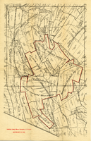
Map of mines owned and operated by Goldfield Deep Mines Company of Nevada, circa 1904-1908
Date
1904 to 1908
Description
Printed on map: 'Boundary in red.'
Image
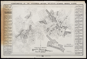
Map of Rawhide Mining District, Nevada, circa 1908
Date
1905 to 1911
Description
'Numbers and black lines show locations of the principal mines, prospects and leases of Rawhide.' 'Compiled by Engraving Department of the Goldfield Review. Olmstead and Rich, Mining Engineers, Goldfield, Nevada.' At top of map: 'Compliments of the Goldfield Review, Nevada's leading mining paper.' Includes index. Published by Goldfield Review Press.
Text

Cross-section maps of Combination and Florence Mines, Goldfield, Nevada, circa 1902-1908
Date
1902 to 1908
Description
Maps of Combination and Florence Mines, Goldfield, Nevada.
Image