Search Results
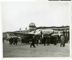
Photograph of crowds surrounding the Lockheed 14 aircraft at Le Bourget Airfield, France, July 1938
Date
1938-07
Archival Collection
Description
The black and white view of crowds surrounding the Lockheed 14 aircraft in Le Bourget Airfield, France. Text printed on the photograph's accompanying strip of paper: As world fliers arrived at Le Bourget, France-- Officials, photographers, and newspapermen, swarming about Howard Hughes' plane, shortly after Hughes and his companions arrived here, completing the transatlantic lef of their sensational flight round-the-world
Image
Carnival Hotel and Casino: Atlantic City, New Jersey, 1976 May 8
Level of Description
Series
Archival Collection
Martin Stern Architectural Records
To request this item in person:
Collection Number: MS-00382
Collection Name: Martin Stern Architectural Records
Box/Folder: N/A
Collection Name: Martin Stern Architectural Records
Box/Folder: N/A
Archival Component
New Frontier Hotel Venus Room: menu, 1956 July 16
Level of Description
Item
Archival Collection
Bob Stoldal Collection of Nevada Menus
To request this item in person:
Collection Number: MS-01093
Collection Name: Bob Stoldal Collection of Nevada Menus
Box/Folder: Oversized Box 03
Collection Name: Bob Stoldal Collection of Nevada Menus
Box/Folder: Oversized Box 03
Archival Component
T-Shirt Color: White; Front: New York City, New York City; Handwritten Text: We Will Never Forget, God Bless NYC, approximately 2001-2012
Level of Description
File
Archival Collection
New York-New York Hotel and Casino 9-11 Heroes Tribute Collection
To request this item in person:
Collection Number: MS-00459
Collection Name: New York-New York Hotel and Casino 9-11 Heroes Tribute Collection
Box/Folder: Box 21
Collection Name: New York-New York Hotel and Casino 9-11 Heroes Tribute Collection
Box/Folder: Box 21
Archival Component
Hoover Dam Service Bureau and Boulder City Theatre covered with snow, approximately 1938-1939
Level of Description
File
Archival Collection
L. F. Manis Photograph Collection
To request this item in person:
Collection Number: PH-00100
Collection Name: L. F. Manis Photograph Collection
Box/Folder: Folder 15
Collection Name: L. F. Manis Photograph Collection
Box/Folder: Folder 15
Archival Component
Unknown author. Vice in New York, Fortune 20(1), 1939 July
Level of Description
File
Archival Collection
UNLV Libraries Collection of Articles on Gaming and Las Vegas, Nevada Topics
To request this item in person:
Collection Number: MS-00626
Collection Name: UNLV Libraries Collection of Articles on Gaming and Las Vegas, Nevada Topics
Box/Folder: Box 09
Collection Name: UNLV Libraries Collection of Articles on Gaming and Las Vegas, Nevada Topics
Box/Folder: Box 09
Archival Component
#69821: A City Withing a City. The Black Freedom Struggle in Grand Rapids, Michigan by Todd E. Robinson on July 30, 2014, 2014 July 30
Level of Description
File
Archival Collection
University of Nevada, Las Vegas Creative Services Records (2010s)
To request this item in person:
Collection Number: PH-00388-05
Collection Name: University of Nevada, Las Vegas Creative Services Records (2010s)
Box/Folder: Digital File 00
Collection Name: University of Nevada, Las Vegas Creative Services Records (2010s)
Box/Folder: Digital File 00
Archival Component

Map of California, Utah, Nevada, Colorado, New Mexico and Arizona, circa 1867
Date
1865 to 1869
Description
39 x 56 cm. Relief shown by hachures. "Entered according to act of Congress in the year 1864, by A.J. Johnson in the Clerks Office of the United States for the Southern District of New York." Atlas page numbers in upper margin: 67-68. Primer meridians: Greenwich and Washington, D.C. On verso: History and statistical view of the West India islands or Columbian Archipelago and Historical and statistical view of Mexico and Central America. Shows proposed railroads, locations of Indian tribes, natural features, counties, mines, mail routes, trails and routes of exploring expeditions. Has decorative border. Southern part of Nevada was added to the state in 1867 and is part of Nevada on this map, but Lincoln County was established in 1867 and is not on this map. This map was still probably published in 1867 in spite of someone's having written "1864" in pencil in the lower right corner of the Library's copy. Original publisher: A.J. Johnson.
Image
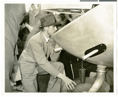
Photograph of Howard Hughes behind his plane at Le Bourget Airfield, France, July 1938
Date
1938-07
Archival Collection
Description
Description printed on photograph's accompanying strip of paper: "Checking damages of plane on arrival at Le Bourget. Le Bourget-- The thoroughness with which he planned the flight and carried it through was still with Howard Hughes when the millionaire flyer and his four companions arrived at Le Bourget, after a record smashing flight across the Atlantic. Hughes is shown here, examining the tail of his plane, just after landing, The tail was damaged slightly. After repairs were made, the fliers took off for Moscow."
Image