Search Results
Wilbur and Toni Clark at a formal dinner at the Hotel Astor in New York City, New York, 1958
Level of Description
File
Archival Collection
Toni and Wilbur Clark Photographs
To request this item in person:
Collection Number: PH-00302
Collection Name: Toni and Wilbur Clark Photographs
Box/Folder: Folder 10
Collection Name: Toni and Wilbur Clark Photographs
Box/Folder: Folder 10
Archival Component

Map of California, Utah, Nevada, Colorado, New Mexico and Arizona, 1864
Date
1864
Description
'Johnson's California, also Utah, Nevada, Colorado, New Mexico, and Arizona, published by A.J. Johnson, New York.' 'Entered according to Act of Congress in the Year 1864, by A.J. Johnson in the Clerks Office of the District Court of the United States for the Southern District of New York.' Atlas page numbers in upper margin: 66-67. Relief shown by hachures. Prime meridians: Greenwich and Washington, D.C. Shows proposed railroads, locations of Indian tribes, natural features, counties, mines, mail routes, trails and routes of exploring expeditions. On verso: History and statistics of Mexico and Central America and statistics of national finances and the Post Office of the United States, 1860. Scale [ca. 1:3,484,800. 1 in. to ca. 55 miles] (W 123°--W 103°/N 42°--N 32°)
Text
Rex Bell in Boulder City, Nevada on with two unidentified women: Handwritten on back "July 4, 1955, Boulder City", 1955 July 04
Level of Description
File
Archival Collection
Walking Box Ranch Photograph Collection
To request this item in person:
Collection Number: PH-00346
Collection Name: Walking Box Ranch Photograph Collection
Box/Folder: N/A
Collection Name: Walking Box Ranch Photograph Collection
Box/Folder: N/A
Archival Component
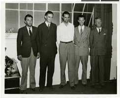
Photograph of Howard Hughes and other men, New York, July 14, 1938
Date
1938-07-14
Archival Collection
Description
Description printed on photograph's accompanying sheet of paper: "Group at [Gover] Whalen's home 7/14/38. (Daily News)." Howard Hughes is standing third from the left.
Image

Photograph of Howard Hughes and other men, New York, July 14, 1938
Date
1938-07-14
Archival Collection
Description
Description printed on photograph's accompanying sheet of paper: "Group at [Gover] Whalen's home 7/14/38. (Daily News)." Howard Hughes is standing third from the left.
Image
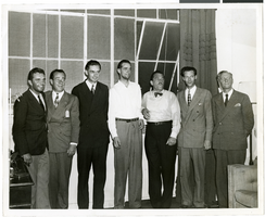
Photograph of Howard Hughes and other men, New York, July 14, 1938
Date
1938-07-14
Archival Collection
Description
Description printed on photograph's accompanying sheet of paper: "Group at [Gover] Whalen's home 7/14/38. (Daily News)." Howard Hughes is standing fourth from the left.
Image
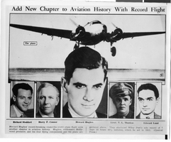
Photograph of Howard Hughes and crew, New York, July 1938
Date
1938-07
Archival Collection
Description
Photograph of a newspaper clipping featuring Howard Hughes and his crew. Typed onto a piece of paper attached to the image: "Crowd waits for glimpse of Howard Hughes as he leaves the home of Al. Lodwick and enters automobile. 7/38."
Image
Del Webb's Sahara Boardwalk-Atlantic City, New Jersey
Level of Description
File
Archival Collection
Martin Stern Architectural Records
To request this item in person:
Collection Number: MS-00382
Collection Name: Martin Stern Architectural Records
Box/Folder: N/A
Collection Name: Martin Stern Architectural Records
Box/Folder: N/A
Archival Component
Harrah's Marina Hotel Casino: Atlantic City, New Jersey
Level of Description
Series
Archival Collection
Martin Stern Architectural Records
To request this item in person:
Collection Number: MS-00382
Collection Name: Martin Stern Architectural Records
Box/Folder: N/A
Collection Name: Martin Stern Architectural Records
Box/Folder: N/A
Archival Component
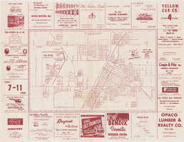
Map of the city of Las Vegas, 1953
Date
1953
Description
24 x 38 cm. on sheet 43 x 56 cm., folded to 28 x 13 cm. Includes advertisements for Las Vegas businesses. Advertisements for Las Vegas businesses, inset map of North Las Vegas, and index on verso. Copyright held by Redwood Pub. Co. Includes inset map of the Strip (U.S. 91 or Los Angeles Highway). Map is irregularly shaped. Original publisher: Redwood Pub. Co..
Image