Search Results
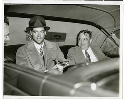
Photograph of Howard Hughes in New York, July 1938
Date
1938-07
Archival Collection
Description
A view of Howard Hughes sitting with two unidentified men in the back of a car, likely being driven to a New York hotel, after landing the Lockheed 14 at Floyd Bennett Field.
Image
Howard Hughes and party being welcomed at City Hall, greeted by Jesse Jones, 1938 July 15
Level of Description
File
Archival Collection
Howard Hughes Public Relations Photograph Collection
To request this item in person:
Collection Number: PH-00373
Collection Name: Howard Hughes Public Relations Photograph Collection
Box/Folder: Folder 12
Collection Name: Howard Hughes Public Relations Photograph Collection
Box/Folder: Folder 12
Archival Component
New York City Center, undated
Level of Description
File
Archival Collection
JMA Architecture Studio Records
To request this item in person:
Collection Number: MS-00783
Collection Name: JMA Architecture Studio Records
Box/Folder: Box 89
Collection Name: JMA Architecture Studio Records
Box/Folder: Box 89
Archival Component
Boyd, W., 1969 July 15
Level of Description
File
Archival Collection
Frank Mitrani Photographs
To request this item in person:
Collection Number: PH-00332
Collection Name: Frank Mitrani Photographs
Box/Folder: Box 21
Collection Name: Frank Mitrani Photographs
Box/Folder: Box 21
Archival Component

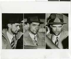
Photograph of Howard Hughes in New York, July 1938
Date
1938-07-14
Archival Collection
Description
Multiple, close up views of Howard Hughes in the back of an automobile in New York. Typed onto a piece of paper attached to the image: "Howard Hughes at Floyd Bennett Airport being interviewed after his record-breaking flight around the world. 7/14/38."
Image
New Mexico travel scenes: Acoma Pueblo-Sky City, Santa Fe, and Las Vegas, New Mexico: photographic negatives, positives, and slides, 1988 July
Level of Description
File
Archival Collection
Wayne C. Kodey Photographs
To request this item in person:
Collection Number: PH-00467
Collection Name: Wayne C. Kodey Photographs
Box/Folder: Box 10
Collection Name: Wayne C. Kodey Photographs
Box/Folder: Box 10
Archival Component
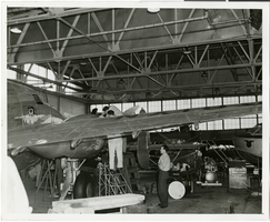
Photograph of the Lockheed 14 aircraft in a hangar in New York, New York, July 9, 1938
Date
1938-07-09
Archival Collection
Description
The black and white view of the Lockheed 14 aircraft in a hangar in New York, New York. Typed on a piece of paper attached to the image: "Readying Hughes' plane for Paris flight-- Mechanics hastened to put Howard Hughes's Lockheed 14 monoplane in shape for a flight from Floyd Bennett Airport herem to Paris. Motor trouble forced postponement and helpers were working under injunction to have the ship ready for a takeoff, July 9, "at the earliest possible moment." Photo shows: Mechanics working on the plane inside the hangar at Floyd Bennett Field. Credit Line (ACME) 7/9/1938."
Image