Search Results
Bodensteiner, Tim, New Vegas, 1982 July 06
Level of Description
File
Archival Collection
Frank Mitrani Photographs
Archival Component
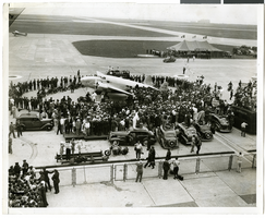
Photograph of crowds at Floyd Bennett Airfield, New York, July 1938
Date
1938-07-14
Archival Collection
Description
The black and white view of Howard Hughes' Lockheed 14 aircraft after performing its final landing on the Round the World flight at Floyd Bennett Airport, New York. Description printed on back of photograph: "General view of welcoming ceremony. 7/14/1938"
Image
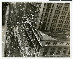
Photograph of a parade procession, New York, July 15, 1938
Date
1938-07-15
Archival Collection
Description
An overhead view of people looking up and waving during a parade procession.
Image
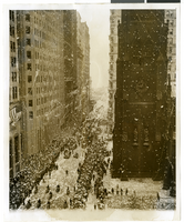
Photograph of a parade procession, New York, July 15, 1938
Date
1938-07-15
Archival Collection
Description
An overhead view of a parade procession celebrating Howard Hughes' completion of his round-the-world flight.
Image
#67121: Valdex, Jesus (Student) Interns at New York-New York, 2009 July 09
Level of Description
File
Archival Collection
University of Nevada, Las Vegas Creative Services Records (2000s)
Archival Component
Photograph of a parade procession, New York, July 15, 1938
Date
1938-07-15
Archival Collection
Description
Description printed on photograph's accompanying sheet of paper: "New York reception for Howard Hughes and his four companions after they completed a round the world flight. 7/15/38."
Image
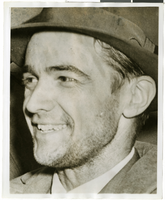
Photograph of Howard Hughes in New York, July 1938
Date
1938-07
Archival Collection
Description
A close-up photograph of Howard Hughes..
Image
Report: "Marketing Casino Gambling and a Local Lottery in New York City" by the Council of the City of New York for the Committee on Economic Development, 1991
Level of Description
File
Archival Collection
Eugene Martin Christiansen Papers
Archival Component
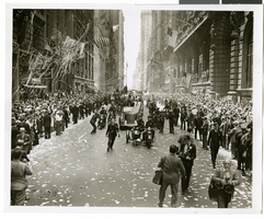
Photograph of a parade procession, New York, July 15, 1938
Date
1938-07-15
Archival Collection
Description
Description printed on photograph's accompanying sheet of paper: "New York reception for Howard Hughes and his companions after completing a round the world flight. 7-15-38 (Press Association)."
Image
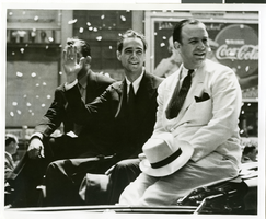
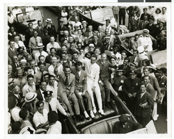
Photograph of a parade procession for Howard Hughes, New York, July 15, 1938
Date
1938-07-15
Archival Collection
Description
Typed onto a piece of paper attached to the image: new York Hails Hughes and Companions, New York City --- In the greatest reception since Lindbergh's, Howard Hughes and his four gallant companions paraded up Broadway July 15 almost smothered beneath Manhattan's ticker tape accolade recognizing their record-smashing Round-the-World flight. This picture shows Hughes, center, waving to the cheering thousands. On the left is Grover Whalen, commissioner of the New York 1939 World's Fair and on the right is Al Lodwick, Hughes' flight manager. 7-15-38. Credit Line (ACME)."
Image