Search Results
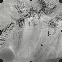
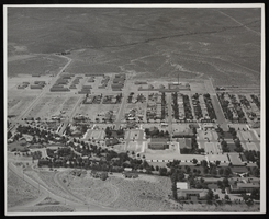
Film transparency of an aerial photo of Boulder City, Nevada, 1974
Date
1974
Archival Collection
Description
An aerial photo of Boulder City, Nevada. The photo was taken in 1974 by Cooper Aerial Surveys, 1692 West Grand Road, Tucson, Arizona 85705, Phone 884-7580.
Image
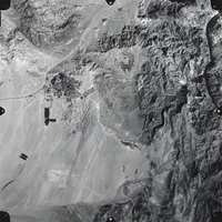
Film transparency of an aerial photo of Boulder City, Nevada, 1974
Date
1974
Archival Collection
Description
An aerial photo of Boulder City, Nevada. The photo was taken in 1974 by Cooper Aerial Surveys, 1692 West Grand Road, Tucson, Arizona 85705, Phone 884-7580.
Image

Map of California and territories of New Mexico and Utah, circa 1861
Date
1856 to 1866
Description
40 x 60 cm. Relief shown by hachures and spot heights. Prime meridians: Greenwich and Washington. Atlas plate numbers 54 and 55 in the upper corners. Shows forts, trails, exploration routes, drainage, mail steamship routes, physical features, Indian tribes, and historic sites. The geographic region of Southwest is referred to as the New Southwest. Original publisher: Johnson .
Image
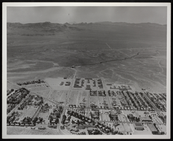
Photograph of an aerial view of Boulder City, Nevada, circa 1930s-1940
Date
1931 to 1940
Archival Collection
Description
Image of an aerial view of Boulder City.
Image
Photograph of an aerial view of Boulder City, Nevada, circa 1931-1940
Date
1931 to 1940
Archival Collection
Description
Image of an aerial view of Boulder City.
Image
American flag with September 11, 2001 and cityscape of New York City where the stars are supposed to be, approximately 2001-2012
Level of Description
File
Archival Collection
New York-New York Hotel and Casino 9-11 Heroes Tribute Collection
To request this item in person:
Collection Number: MS-00459
Collection Name: New York-New York Hotel and Casino 9-11 Heroes Tribute Collection
Box/Folder: Box 479
Collection Name: New York-New York Hotel and Casino 9-11 Heroes Tribute Collection
Box/Folder: Box 479
Archival Component
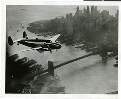
Photograph of the Lockheed 14 aircraft, July 1938
Date
1938-07
Archival Collection
Description
The black and white, skyline view of New York City with the Lockheed 14 aircraft flying in the foreground.
Image
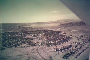
Film transparency of Boulder City, Nevada, circa 1931-1936
Date
1931 to 1936
Archival Collection
Description
An image showing an aerial view of Boulder City. The outlines of the small city are distinctively marked by the stark contrast between the city's greenery and the surrounding desert. In the far distance, the shores of Lake Mead can be seen peaking out from behind the mountains. Note: Bits of the airplane from which the image itself was taken can be seen in the upper right corner of the photograph.
Image
T-Shirt Color: Gray; Front: FDNY Fire Dept. City Of New York, Dept. Emblem, approximately 2001-2012
Level of Description
File
Archival Collection
New York-New York Hotel and Casino 9-11 Heroes Tribute Collection
To request this item in person:
Collection Number: MS-00459
Collection Name: New York-New York Hotel and Casino 9-11 Heroes Tribute Collection
Box/Folder: Box 08
Collection Name: New York-New York Hotel and Casino 9-11 Heroes Tribute Collection
Box/Folder: Box 08
Archival Component