Search Results
New York Mine, Silver City, Nevada, undated
Level of Description
File
Archival Collection
Mary Griffith Toleno Photograph Collection
Archival Component
New York Mine, Silver City, Nevada, undated
Level of Description
File
Archival Collection
Mary Griffith Toleno Photograph Collection
Archival Component
New York Mine, Silver City, Nevada, undated
Level of Description
File
Archival Collection
Mary Griffith Toleno Photograph Collection
Archival Component
New York Mine, Silver City, Nevada, undated
Level of Description
File
Archival Collection
Mary Griffith Toleno Photograph Collection
Archival Component
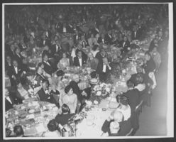
Photograph of a formal dinner at the Hotel Astor, New York City, 1958
Date
1958
Archival Collection
Description
A Formal dinner at the Hotel Astor in New York City, 1958. Wilbur Clark is located at the center of the picture, leaning his elbow on the table to the right. (Credit: Bill Mark, Park Sheraton Hotel, NYC.)
Image

Map of California, Utah, Nevada, Colorado, New Mexico and Arizona, 1864
Date
1864
Description
'Johnson's California, also Utah, Nevada, Colorado, New Mexico, and Arizona, published by A.J. Johnson, New York.' 'Entered according to Act of Congress in the Year 1864, by A.J. Johnson in the Clerks Office of the District Court of the United States for the Southern District of New York.' Atlas page numbers in upper margin: 66-67. Relief shown by hachures. Prime meridians: Greenwich and Washington, D.C. Shows proposed railroads, locations of Indian tribes, natural features, counties, mines, mail routes, trails and routes of exploring expeditions. On verso: History and statistics of Mexico and Central America and statistics of national finances and the Post Office of the United States, 1860. Scale [ca. 1:3,484,800. 1 in. to ca. 55 miles] (W 123°--W 103°/N 42°--N 32°)
Text
Harrah's Grand, Atlantic City, New Jersey, 2001
Level of Description
File
Archival Collection
Robert Beckmann Photographs
Archival Component

Photograph of a parade procession for Howard Hughes, New York, July 15, 1938
Date
1938-07-15
Archival Collection
Description
Description printed on photograph's accompanying sheet of paper: "Hughes waves to cheering million. New York City--- Clean-shaven once more, Howard Hughes smiles his gratitude to the millions of New Yorkers who showered him with ticker-tape and torn paper--New York's own accolade, as paraded up Broadway, followed by his companions in the carbehind in the greatest reception since Lindbergh's. On the left is Grover Whalen, head of the New York World's Fair, 1939, and on the right, Al Lodwick, manager of the round-the-world record smashing flight. Credit Line (ACME) 7/15/38."
Image
#64226: New Leadership Nevada, 2004 June 15
Level of Description
File
Archival Collection
University of Nevada, Las Vegas Creative Services Records (2000s)
Archival Component
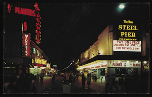
Nighttime view of Atlantic City, New Jersey: postcard
Date
1940 (year approximate) to 1990 (year approximate)
Archival Collection
Description
From Harvey's Hotel and Casino Postcard Collection (PH-00367)
Image