Search Results
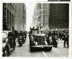
Photograph of Howard Hughes and his crew at a parade, New York, July 15, 1938
Date
1938-07-15
Archival Collection
Description
Typed onto a piece of paper attached to the image: "Howard Hughes and crew in parade up Broadway after record-breaking world flight. New York, New York."
Image
Photograph of Howard Hughes and crew at a parade, New York, July 15, 1938
Date
1938-07-15
Archival Collection
Description
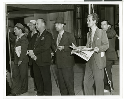
Description printed photograph's accompanying sheet of paper: "They also flew! New York City--- Heroes yesterday, spectators today. Standing obscurely on the sidelines while New York acclaimed Howard Hughes and his four companions with a typical ticker-tape parade up Broadway, were two men respective aeronautical feats also set the world agog. Second from left is Capt. J. Erroll Boyd, who flew from Toronto, Can, to London in 1930. On that flight he had as his companion and navigator Harry P. M. Connor, who served in the same capacity on the Hughes flight. Beside Boyd, (smoking cigarette) is Roger Q. Williams, who, in 1929, flew from Old Orchard Beach, ME, to Rome. Credit Line (ACME) 7/15/38 (FULL)"
Image
Coalition for Casino Gambling: plan for New York City, undated
Level of Description
File
Archival Collection
Eugene Martin Christiansen Papers
To request this item in person:
Collection Number: MS-00561
Collection Name: Eugene Martin Christiansen Papers
Box/Folder: Box 163
Collection Name: Eugene Martin Christiansen Papers
Box/Folder: Box 163
Archival Component
New York City Council news reports and correspondence, 1990
Level of Description
File
Archival Collection
Eugene Martin Christiansen Papers
To request this item in person:
Collection Number: MS-00561
Collection Name: Eugene Martin Christiansen Papers
Box/Folder: Box 163
Collection Name: Eugene Martin Christiansen Papers
Box/Folder: Box 163
Archival Component
"The Meadowlands and New York City's Harness Racing Industry", 1987
Level of Description
File
Archival Collection
Eugene Martin Christiansen Papers
To request this item in person:
Collection Number: MS-00561
Collection Name: Eugene Martin Christiansen Papers
Box/Folder: Box 049
Collection Name: Eugene Martin Christiansen Papers
Box/Folder: Box 049
Archival Component
Photograph of Howard Hughes and his crew at a parade, New York, July 15, 1938
Date
1938-07-15
Archival Collection
Description
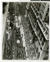
Description printed on photograph's accompanying sheet of paper: "Gen. view parade: As globe fliers braved Broadway blizzard, New York. Although they didn't encounter a single snowflake on their roaring dash across Siberia, Howard Hughes and his four-man crew met a regular blizzard (of Broadway ticker tape) today as New York paid them homage as only New York know how. This is a view of the scene as the triumphal procession proceeded from the Battery to City Call. In the car are (left to right) Grover Whalen, President of the New York World's Fair, Howard Hughes and Al Lodwick, his press representative. (w) 7-15-38.30."
Image
New York City Pizza, menu, approximately 1961 to 1990
Level of Description
File
Archival Collection
UNLV University Libraries Menu Collection
To request this item in person:
Collection Number: MS-00436
Collection Name: UNLV University Libraries Menu Collection
Box/Folder: Box 35
Collection Name: UNLV University Libraries Menu Collection
Box/Folder: Box 35
Archival Component
T-Shirt Color: Gray; Front: City Of New York Fire Dept. FDNY, Dept. Badge W/ New York City Sky Line, approximately 2001-2012
Level of Description
File
Archival Collection
New York-New York Hotel and Casino 9-11 Heroes Tribute Collection
To request this item in person:
Collection Number: MS-00459
Collection Name: New York-New York Hotel and Casino 9-11 Heroes Tribute Collection
Box/Folder: Box 357
Collection Name: New York-New York Hotel and Casino 9-11 Heroes Tribute Collection
Box/Folder: Box 357
Archival Component
Adamar of New Jersey License Application, December 15, 1981
Level of Description
File
Archival Collection
International Association of Gaming Attorneys Collection
To request this item in person:
Collection Number: MS-00250
Collection Name: International Association of Gaming Attorneys Collection
Box/Folder: Box 01
Collection Name: International Association of Gaming Attorneys Collection
Box/Folder: Box 01
Archival Component
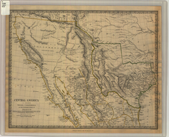
Map of Texas, California, New Mexico and the northern states of Mexico, October 15, 1842
Date
1842-10-15
Description
'Published under the superintendence of the Society for Diffusion of Useful Knowledge.' 'Published by Chapman & Hall, 186 Strand, 15 Oct. 1842.' 'J. & C. Walker, Sculpt.' Scale [ca. 1:7,600,000]. 1 in. to ca. 120 miles (W 125°--W 91°/N 43°--N 23° 30?). 1 map ; 31 x 39 cm. Relief indicated by hachures and spot heights. Shows elevations in yards. Includes notes on exploring expeditions, etc. Borders hand colored. Chapman & Hall.
Image