Search Results
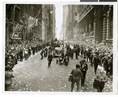
Photograph of a parade procession, New York, July 15, 1938
Date
1938-07-15
Archival Collection
Description
Description printed on photograph's accompanying sheet of paper: "New York reception for Howard Hughes and his companions after completing a round the world flight. 7-15-38 (Press Association)."
Image

Map of California and territories of New Mexico and Utah, circa 1861
Date
1859 to 1862
Description
'Compiled, drawn, and engraved under the supervision of J.H. Colton and A.J. Johnson.' Relief shown by hachures and spot heights. Scale [ca. 1:3,041,280]. 1 in. to approx. 48 miles (W 124°--W 103°/N 42°--N 31°). Hand colored
Prime meridians: Greenwich and Washington
Plates 54 & 55 removed from Johnson's New illustrated family atlas of the world, with descriptions geographical, statistical and historical ... New York, 1862
Title page of atlas.
Prime meridians: Greenwich and Washington
Plates 54 & 55 removed from Johnson's New illustrated family atlas of the world, with descriptions geographical, statistical and historical ... New York, 1862
Title page of atlas.
Image
Minority Recruiting in the New York City Police Department by the New York City Rand Institute, 1971 May
Level of Description
File
Archival Collection
Ardis Kearns Papers
To request this item in person:
Collection Number: MS-00348
Collection Name: Ardis Kearns Papers
Box/Folder: Box 18
Collection Name: Ardis Kearns Papers
Box/Folder: Box 18
Archival Component
The Police Internal Administration of Justice in New York City by the New York City Rand Institute, 1970 November
Level of Description
File
Archival Collection
Ardis Kearns Papers
To request this item in person:
Collection Number: MS-00348
Collection Name: Ardis Kearns Papers
Box/Folder: Box 19
Collection Name: Ardis Kearns Papers
Box/Folder: Box 19
Archival Component
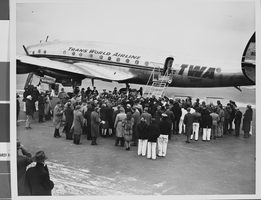
Photograph of Trans World Airline flight, New York, February 15, 1946
Date
1943 to 1945
Archival Collection
Description
Description given with photo: "Non-Stop Los Angeles - New York Flight Inaugurated New York -- View of the crowd around the "Star of California" waiting for passengers -- most of them after it landed at LaGuardia Airport Feb. 15. Piloted by Howard Hughes, famed Around-The-World record holder and a TWA executive, the flight in-augurated non-stop schedule between Los Angeles and New York. The TWA Constellation made the trip in 8 hours and 38 minutes, as compared with the record of 7 hours, 27 minutes. Credit (ACME) 2/15/46."
Image
Howard Hughes and his crew arriving at New York City Hall after their around-the-world flight, 1938 July 15
Level of Description
File
Archival Collection
Howard Hughes Public Relations Photograph Collection
To request this item in person:
Collection Number: PH-00373
Collection Name: Howard Hughes Public Relations Photograph Collection
Box/Folder: Folder 12
Collection Name: Howard Hughes Public Relations Photograph Collection
Box/Folder: Folder 12
Archival Component