Search Results
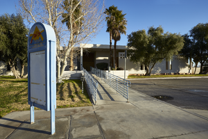
Signage in front of the former North Las Vegas City Hall building on Civic Center Drive in North Las Vegas, Nevada: digital photograph
Date
Archival Collection
Description
From the UNLV University Libraries Photographs of the Development of the Las Vegas Valley, Nevada (PH-00394). Part of the collection documents the entire 19 mile length of the north/south Eastern Avenue / Civic Center Drive alignment. This photograph was captured in the section of Civic Center Drive between Las Vegas Boulevard and Lake Mead Boulevard.
Image

Las Vegas City Engineering and Planning Department Reports
Identifier
Abstract
The Las Vegas City Engineering and Planning Department Reports (1951-1981) consist of urban planning reports, transportation and parking studies, and environmental impact assessments concerning the greater Las Vegas, Nevada metropolitan area. In addition to general issues of urban planning, the collection contains materials relating to the expansion of Interstate 15 through West Las Vegas in the 1970s and early 1980s.
Archival Collection
MGM Grand Hotel: Atlantic City, New Jersey, 1980 September 18; 1982 February 2
Level of Description
Archival Collection
Collection Name: Martin Stern Architectural Records
Box/Folder: N/A
Archival Component
The Claridge Hotel and Casino: Atlantic City, New Jersey, 1979 December 17; 1984 May 9
Level of Description
Archival Collection
Collection Name: Martin Stern Architectural Records
Box/Folder: N/A
Archival Component
Hall, Jan and Elizabeth, 1988 July 20
Level of Description
Archival Collection
Collection Name: Frank Mitrani Photographs
Box/Folder: Box 55
Archival Component
Marble City, 1967
Level of Description
Archival Collection
Collection Name: Las Vegas Library Regional History Files Collection
Box/Folder: Box 15
Archival Component