Search Results

Photograph of the landing of Howard Hughes' Lockheed 14 aircraft, New York, July 14, 1938
Date
1938-07-14
Archival Collection
Description
The black and white, view of Howard Hughes' Lockheed 14 aircraft performing its final landing on the Round the World flight at Floyd Bennett Airport, New York. Typed onto a piece of paper attached to the image: "Scene at Floyd Bennett Field as Howard Hughes and his crew landed after completing a round the world flight..... 7-14-38. (Press Association)"
Image
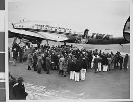
Photograph of Trans World Airline flight, New York, February 15, 1946
Date
1943 to 1945
Archival Collection
Description
Description given with photo: "Non-Stop Los Angeles - New York Flight Inaugurated New York -- View of the crowd around the "Star of California" waiting for passengers -- most of them after it landed at LaGuardia Airport Feb. 15. Piloted by Howard Hughes, famed Around-The-World record holder and a TWA executive, the flight in-augurated non-stop schedule between Los Angeles and New York. The TWA Constellation made the trip in 8 hours and 38 minutes, as compared with the record of 7 hours, 27 minutes. Credit (ACME) 2/15/46."
Image
#64818: New Chair in Artemus W. Ham Concert Hall, 2005 September 08
Level of Description
File
Archival Collection
University of Nevada, Las Vegas Creative Services Records (2000s)
To request this item in person:
Collection Number: PH-00388-04
Collection Name: University of Nevada, Las Vegas Creative Services Records (2000s)
Box/Folder: N/A
Collection Name: University of Nevada, Las Vegas Creative Services Records (2000s)
Box/Folder: N/A
Archival Component
Howard Hughes and the Lockheed 14 aircraft, Fairbanks, Alaska, 1938 July 15
Level of Description
File
Archival Collection
Howard Hughes Public Relations Photograph Collection
To request this item in person:
Collection Number: PH-00373
Collection Name: Howard Hughes Public Relations Photograph Collection
Box/Folder: Folder 07
Collection Name: Howard Hughes Public Relations Photograph Collection
Box/Folder: Folder 07
Archival Component
Howard Hughes at the celebration of his around-the-world flight, 1938 July 15
Level of Description
File
Archival Collection
Howard Hughes Public Relations Photograph Collection
To request this item in person:
Collection Number: PH-00373
Collection Name: Howard Hughes Public Relations Photograph Collection
Box/Folder: Folder 12
Collection Name: Howard Hughes Public Relations Photograph Collection
Box/Folder: Folder 12
Archival Component
Captain J. Erroll Boyd, Harry P. M. Connor, and Roger Q. Williams, 1938 July 15
Level of Description
File
Archival Collection
Howard Hughes Public Relations Photograph Collection
To request this item in person:
Collection Number: PH-00373
Collection Name: Howard Hughes Public Relations Photograph Collection
Box/Folder: Folder 10
Collection Name: Howard Hughes Public Relations Photograph Collection
Box/Folder: Folder 10
Archival Component
United Artists distribution contracts, 1931 June 30 to 1938 June 15
Level of Description
File
Archival Collection
Howard Hughes Film Production Records
To request this item in person:
Collection Number: MS-01036
Collection Name: Howard Hughes Film Production Records
Box/Folder: Box 516 (Restrictions apply)
Collection Name: Howard Hughes Film Production Records
Box/Folder: Box 516 (Restrictions apply)
Archival Component
Frank Moss director contract, 1938 November 15 to 1940 October 11
Level of Description
File
Archival Collection
Howard Hughes Film Production Records
To request this item in person:
Collection Number: MS-01036
Collection Name: Howard Hughes Film Production Records
Box/Folder: Box 520 (Restrictions apply)
Collection Name: Howard Hughes Film Production Records
Box/Folder: Box 520 (Restrictions apply)
Archival Component