Search Results
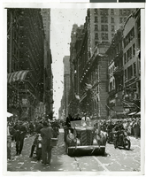
Photograph of Howard Hughes and his crew at a parade, New York, July 15, 1938
Date
1938-07-15
Archival Collection
Description
Description printed on photograph's accompanying sheet of paper: "Howard Hughes' parade up broadway. General scene of parade. 7/15/38."
Image

City Swiss Club, annual banquet, menu, Friday, December 12, 1902, at The Monico International Hall
Date
1902-12-12
Archival Collection
Description
Note: Printed on the premises Menu insert: Toasts Restaurant: The Monico Location: Piccadilly Circus, W., London, England
Text
Colburn's New Monthly Magazine and Humorist, no. 304. London: Chapman and Hall, 1846 April 01
Level of Description
Item
Archival Collection
Mavis Eggle "Books as They Were Bought" Collection
To request this item in person:
Collection Number: MS-01144
Collection Name: Mavis Eggle "Books as They Were Bought" Collection
Box/Folder: Box 05
Collection Name: Mavis Eggle "Books as They Were Bought" Collection
Box/Folder: Box 05
Archival Component
North Las Vegas Libriary under construction and City Hall, Civic Center Drive, 1965
Level of Description
File
Archival Collection
North Las Vegas Library Photograph Collection on North Las Vegas, Nevada
To request this item in person:
Collection Number: PH-00277
Collection Name: North Las Vegas Library Photograph Collection on North Las Vegas, Nevada
Box/Folder: Folder 04
Collection Name: North Las Vegas Library Photograph Collection on North Las Vegas, Nevada
Box/Folder: Folder 04
Archival Component
Polaroid of Showboat billboard advertising Megabucks, Atlantic City, New Jersey, 1986
Level of Description
Item
Archival Collection
Showboat Atlantic City Photograph Collection
To request this item in person:
Collection Number: PH-00329
Collection Name: Showboat Atlantic City Photograph Collection
Box/Folder: Folder 01
Collection Name: Showboat Atlantic City Photograph Collection
Box/Folder: Folder 01
Archival Component
Gamblers in the Showboat Casino, Atlantic City, New Jersey, black-and-white, 1986
Level of Description
Item
Archival Collection
Showboat Atlantic City Photograph Collection
To request this item in person:
Collection Number: PH-00329
Collection Name: Showboat Atlantic City Photograph Collection
Box/Folder: Folder 01
Collection Name: Showboat Atlantic City Photograph Collection
Box/Folder: Folder 01
Archival Component
Exterior view of Showboat Casino in the evening, Atlantic City, New Jersey, 1986
Level of Description
Item
Archival Collection
Showboat Atlantic City Photograph Collection
To request this item in person:
Collection Number: PH-00329
Collection Name: Showboat Atlantic City Photograph Collection
Box/Folder: Folder 01
Collection Name: Showboat Atlantic City Photograph Collection
Box/Folder: Folder 01
Archival Component
Construction of the Showboat Casino high-rise, Atlantic City, New Jersey, 1986
Level of Description
Item
Archival Collection
Showboat Atlantic City Photograph Collection
To request this item in person:
Collection Number: PH-00329
Collection Name: Showboat Atlantic City Photograph Collection
Box/Folder: Folder 01
Collection Name: Showboat Atlantic City Photograph Collection
Box/Folder: Folder 01
Archival Component