Search Results

Map of Las Vegas and vicinity, Nevada, circa 1957-1961
Date
1957 to 1961
Description
70 x 68 cm. on sheet 106 x 71 cm. Includes indexes. Includes Nellis Air Force Base, Henderson, and inset maps of Boulder City, Nevada, and Las Vegas's geographical location in the Southwest. "H-654-32" on the lower right-hand corner. Page 2 contains a photograph of the Fremont Street in Downtown Las Vegas, featuring the Golden Nugget Gambling Hall and the Horseshoe Casino. Page 3 outlines local and regional attractions, as well as population information. Original publisher: R. L. Polk.
Image
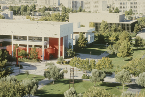
Slide of James R. Dickinson Library, William D. Carlson Education Building and Artemus W. Ham Concert Hall, University of Nevada, Las Vegas, circa 1981-1989
Date
1981 to 1989
Archival Collection
Description
Aerial view of James R. Dickinson Library, William D. Carlson Educaiton Building and Artemus W. Ham Concert Hall, University of Nevada, Las Vegas. The clock tower is seen on the East Mall.
Image
Las Vegas City Commission Minutes, December 8, 1959 to February 17, 1960
Date
1959-12-08 to 1960-02-17
Archival Collection
Description
Bound volume of Las Vegas City Commission Minutes, December 8, 1959 to February 17, 1960
Text
Las Vegas City Commission Minutes, November 20, 1957 to December 2, 1959
Date
1957-11-20 to 1959-12-02
Archival Collection
Description
Bound volume of Las Vegas City Commission Minutes, November 20, 1957 to December 2, 1959
Text
Las Vegas City Commission Minutes, November 7, 1949 to May 21, 1952
Date
1949-11-07 to 1952-05-21
Archival Collection
Description
Bound volume of Las Vegas City Commission Minutes, November 7, 1949 to May 21, 1952
Text
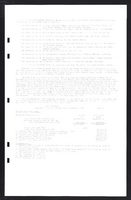
Las Vegas City Commission Minutes, February 17, 1937 to August 4, 1942
Date
1937-02-17 to 1942-08-04
Archival Collection
Description
Bound volume of Las Vegas City Commission Minutes, February 17, 1937 to August 4, 1942
Text
Las Vegas City Commission Minutes, January 7, 1947 to October 26, 1949
Date
1947-01-07 to 1949-10-26
Archival Collection
Description
Bound volume of Las Vegas City Commission Minutes, January 7, 1947 to October 26, 1949
Text
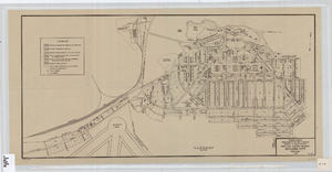
Cadastral map of Boulder City, Nevada, 1940
Date
1905-04-23
Description
A. M. S. Jan. 1940 in the lower left-hand corner. 1 map ; 61 x 30 cm. Cadastral map. "No. 40-1" in the lower right-hand corner. Shows block and lot numbers, buildings, water supply and sewage system, leased areas.
Image