Search Results

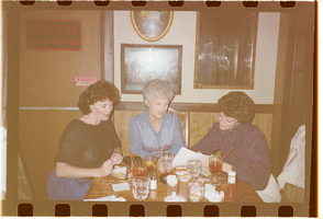
Film transparency of Chris Hall, Blanche Zucker and Shelley Berkley at a restaurant, mid-1980s
Date
1983 to 1986
Description
L-R: Chris Hall, Blanche Zucker and Nevada Congresswoman Shelley Berkley at a restaurant.
Image
Film transparency of Chris Hall, Blanche Zucker and Shelley Berkley at a restaurant, mid-1980s
Date
1983 to 1986
Description
L-R: Chris Hall, Blanche Zucker and Nevada Congresswoman Shelley Berkley at a restaurant.
Image
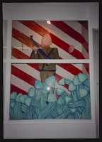
UNLV Grant Hall art exhibit, image 001: photographic print
Date
1990-12
Archival Collection
Description
Grant Hall art exhibit - UNLV. Dec. 1990.
Image
Hall, Frank, 1987 April 01
Level of Description
File
Archival Collection
Frank Mitrani Photographs
To request this item in person:
Collection Number: PH-00332
Collection Name: Frank Mitrani Photographs
Box/Folder: Box 45
Collection Name: Frank Mitrani Photographs
Box/Folder: Box 45
Archival Component
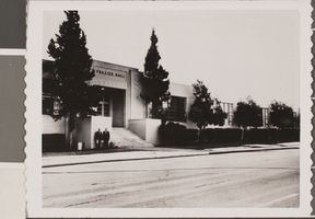
Photograph of Frazier Hall, Las Vegas, circa 1950s
Date
1950 to 1959
Archival Collection
Description
Description provided with image: "Frazier Hall at its first location (Las Vegas High School). It later moved to its present location on Maryland Parkway."
Image
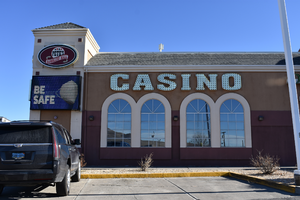
Pete's Gambling Hall wall mounted signs, Winnemucca, Nevada
Date
2020
Archival Collection
Description
View of the wall mounted signs for Pete's Gambling Hall during the day with unlit neon.
1985 W Winnemucca Blvd, Winnemucca, NV 89445
Pete's Gambling Hall
Image
Mandarin Hall, 1981 December 18
Level of Description
File
Archival Collection
Frank Mitrani Photographs
To request this item in person:
Collection Number: PH-00332
Collection Name: Frank Mitrani Photographs
Box/Folder: Box 56
Collection Name: Frank Mitrani Photographs
Box/Folder: Box 56
Archival Component

Photograph of Casino Monte Carlo's concert hall, Monte Carlo (Monaco), 1930s
Date
1930 to 1939
Archival Collection
Description
A black and white oversized picture of the Salle De Concert inside Casino Monte Carlo which is located in Monaco on the southern coast of France. In French, "Salle De Concert" means 'concert hall.'
Image
Silver Slipper Gambling Hall, undated
Level of Description
File
Archival Collection
Ruthe Scott Photographs of Las Vegas, Nevada Hotels and Casinos
To request this item in person:
Collection Number: PH-00220
Collection Name: Ruthe Scott Photographs of Las Vegas, Nevada Hotels and Casinos
Box/Folder: Box SH-028
Collection Name: Ruthe Scott Photographs of Las Vegas, Nevada Hotels and Casinos
Box/Folder: Box SH-028
Archival Component
#69825: UNLV graduate Lisa Morris Hibbler poses at Las Vegas City Hall July 31, 2014 in Las Vegas, 2014 July 31
Level of Description
File
Archival Collection
University of Nevada, Las Vegas Creative Services Records (2010s)
To request this item in person:
Collection Number: PH-00388-05
Collection Name: University of Nevada, Las Vegas Creative Services Records (2010s)
Box/Folder: Digital File 00
Collection Name: University of Nevada, Las Vegas Creative Services Records (2010s)
Box/Folder: Digital File 00
Archival Component