Search Results
Silver Slipper Gambling Hall, undated
Level of Description
File
Archival Collection
Ruthe Scott Photographs of Las Vegas, Nevada Hotels and Casinos
To request this item in person:
Collection Number: PH-00220
Collection Name: Ruthe Scott Photographs of Las Vegas, Nevada Hotels and Casinos
Box/Folder: Box SH-028
Collection Name: Ruthe Scott Photographs of Las Vegas, Nevada Hotels and Casinos
Box/Folder: Box SH-028
Archival Component
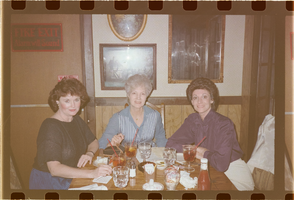
Film transparency of Chris Hall, Blanche Zucker and Shelley Berkley at a restaurant, mid-1980s
Date
1983 to 1986
Description
L-R: Chris Hall, Blanche Zucker and Nevada Congresswoman Shelley Berkley at a restaurant.
Image

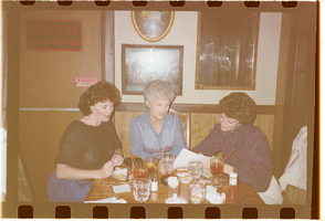
Film transparency of Chris Hall, Blanche Zucker and Shelley Berkley at a restaurant, mid-1980s
Date
1983 to 1986
Description
L-R: Chris Hall, Blanche Zucker and Nevada Congresswoman Shelley Berkley at a restaurant.
Image
Film transparency of Chris Hall, Blanche Zucker and Shelley Berkley at a restaurant, mid-1980s
Date
1983 to 1986
Description
L-R: Chris Hall, Blanche Zucker and Nevada Congresswoman Shelley Berkley at a restaurant.
Image
Hall, Fred, 1969 January 08
Level of Description
File
Archival Collection
Frank Mitrani Photographs
To request this item in person:
Collection Number: PH-00332
Collection Name: Frank Mitrani Photographs
Box/Folder: Box 03
Collection Name: Frank Mitrani Photographs
Box/Folder: Box 03
Archival Component
#69825: UNLV graduate Lisa Morris Hibbler poses at Las Vegas City Hall July 31, 2014 in Las Vegas, 2014 July 31
Level of Description
File
Archival Collection
University of Nevada, Las Vegas Creative Services Records (2010s)
To request this item in person:
Collection Number: PH-00388-05
Collection Name: University of Nevada, Las Vegas Creative Services Records (2010s)
Box/Folder: Digital File 00
Collection Name: University of Nevada, Las Vegas Creative Services Records (2010s)
Box/Folder: Digital File 00
Archival Component
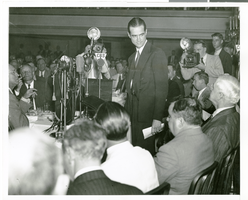
Photograph of Howard Hughes speaking at the National Press Club, New York City, July 15, 1938
Date
1938-07-15
Archival Collection
Description
Typed onto a piece of paper attached to the image: "Howard Hughes and his four companions honored at the National Press Club. Howard Hughes is speaking, with Mayor La Guardia and Secretary of State Cordell Hull at lower right. July 1938."
Image

Photograph of Casino Monte Carlo's concert hall, Monte Carlo (Monaco), 1930s
Date
1930 to 1939
Archival Collection
Description
A black and white oversized picture of the Salle De Concert inside Casino Monte Carlo which is located in Monaco on the southern coast of France. In French, "Salle De Concert" means 'concert hall.'
Image
Boulder City, Nevada Financial Reports and Budgets
Identifier
MS-00695
Abstract
Collection is comprised of annual budgets, financial statements, and auditor's reports dating from 1976 to 1989 created for the city of Boulder City, Nevada and adopted by the City Council.
Archival Collection
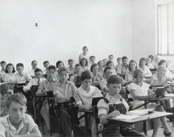
Photograph of Boulder City Elementary School, Boulder City, Nevada, October 5, 1932
Date
1932-10-05
Archival Collection
Description
Black and white image of the first eighth grade class of Boulder City Elementary School, currently the home of City Hall, located at 401 California Avenue in Boulder City. The principal of the school, Miss Leila Tilley, is visible in the back of the classroom behind the students.
Image