Search Results
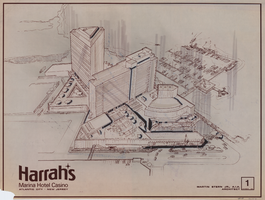
Architectural drawing of Harrah's Marina Hotel Casino (Atlantic City), alterations and sketches of the site plan study, October 15, 1981
Date
Archival Collection
Description
Plans for proposed changes to Harrah's Marina Hotel Casino in Atlantic City. Transferred onto parchment using the ozalid process.
Site Name: Harrah's Marina Resort (Atlantic City)
Address: 777 Harrah's Boulevard, Atlantic City, NJ
Image
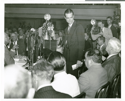
Photograph of Howard Hughes speaking at the National Press Club, New York City, July 15, 1938
Date
Archival Collection
Description
Image

Plat of H.F.M & M addition to city of Las Vegas, Clark County, Nevada, comprising the west 1/2 of N.W. 1/4 Sec. 27, Twp. 20 S., R. 61 E., M.D.B & M, March 8, 1924
Date
Description
Blue-line print ; 74 x 36 cm on sheet 79 x 61 cm. Survey was competed on March 8, 1924. Signed by the owners of the piece of property for the addition Roy W. Martin, Forest R. Mildren, William E. Ferron, and A. W. Ham, signed by the surveyor J.T. McWilliams, and notarized on March 31, 1924. Approved by the Board of City Commissioners and signed by the major W. C. German and by Florence S. Doherty, city clerk, on April 1, 1924. Recorded in Book 1 of plats, page 47. Includes township and range grid.
Image
Boulder City, Nevada Financial Reports and Budgets
Identifier
Abstract
Collection is comprised of annual budgets, financial statements, and auditor's reports dating from 1976 to 1989 created for the city of Boulder City, Nevada and adopted by the City Council.
Archival Collection
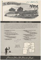
Sales material for the Granada model home in the El Encanto development, Las Vegas, Nevada, 1967-1969
Date
Archival Collection
Description
Sales material from the late 1960s for model no. 15 A residential home, called "The Granada," in the El Encanto development, Las Vegas, Nevada. One side has an illustration of the front exterior elevation, a floor plan, and a list of features. The other side shows two alternate exterior elevation illustrations (15A-3-L and 15A-1-R). The price is handwritten. The development is located between Harmon and Tropicana Avenues (north and south) and Sandhill Rd. (west) and S. Lamb Blvd. (east).
Site Name: El Encanto (Las Vegas, Nevada)
Text
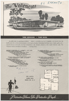
Sales material for the Valencia model home in the El Encanto development, Las Vegas, Nevada, 1967-1969
Date
Archival Collection
Description
Sales material from the late 1960s for model no. 15 B residential home, called "The Valencia," in the El Encanto development, Las Vegas, Nevada. One side has an illustration of the front exterior elevation, a floor plan, and a list of features. The other side shows two alternate exterior elevation illustrations (15B-3-R and 15B-2-R). The price is handwritten. The development is located between Harmon and Tropicana Avenues (north and south) and Sandhill Rd. (west) and S. Lamb Blvd. (east).
Site Name: El Encanto (Las Vegas, Nevada)
Text
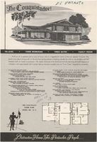
Sales material for the Conquistador model home in the El Encanto development, Las Vegas, Nevada, 1967-1969
Date
Archival Collection
Description
Sales material from the late 1960s for model no. 15 C residential home called "The Conquistador," in the El Encanto development, Las Vegas, Nevada. One side has an illustration of the front exterior elevation, a floor plan, and a list of features. The other side shows two alternate exterior elevation illustrations (15C-1-L and 15C-2-R). The price is handwritten. The development is located between Harmon and Tropicana Avenues (north and south) and Sandhill Rd. (west) and S. Lamb Blvd. (east).
Site Name: El Encanto (Las Vegas, Nevada)
Text
Kyle and Lee Canyons, Spring Mountain, Belknap Photographic Services, Boulder City, Nevada, 1952 July 15
Level of Description
Archival Collection
Collection Name: Chester R. Longwell Professional Papers
Box/Folder: Box 24
Archival Component
Howard Hughes, Mayor Fiorello La Guardia, and Grover Whalen leaving City Hall, 1938 July 15
Level of Description
Archival Collection
Collection Name: Howard Hughes Public Relations Photograph Collection
Box/Folder: Folder 13
Archival Component
Howard Hughes inside of City Hall after completing his around-the-world flight, 1938 July 15
Level of Description
Archival Collection
Collection Name: Howard Hughes Public Relations Photograph Collection
Box/Folder: Folder 12
Archival Component