Search Results
Robert E. "Spud" Lake Photographs
Identifier
Abstract
The Robert E. "Spud" Lake Photographs depict "Spud" Lake, his family, and Las Vegas, Nevada from 1905 to 1947. The photographs include the Las Vegas town site auction, Stewart (Kiel) Ranch, Clark County Courthouse, Eglington Ranch, Helldorado Parade, and Colorado River and the Hoover (Boulder) Dam. The photographs also depict a Las Vegas Chamber of Commerce luncheon honoring Las Vegas pioneers, the Gold Bar Club tent in Pahrump, Nevada, and Fremont Street in Las Vegas.
Archival Collection
Union Pacific Railroad Photographs
Identifier
Abstract
The Union Pacific Railroad Photographs depict the Union Pacific Railroad Company's tracks, depots, locomotives, and stations in Southern Nevada and Southern California from 1904 to 1973. The photographs primarily depict Union Pacific officials in Las Vegas, Nevada, construction of Boulder City, Nevada and the Hoover (Boulder) Dam, hotels and casinos in Las Vegas, and the aftermath of flooding in 1938 that damaged Union Pacific tracks.
Archival Collection
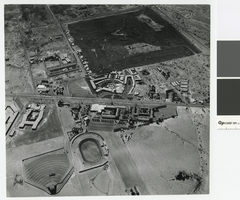
Aerial photograph of the Last Frontier and Wilbur Clark's Desert Inn, Las Vegas, circa 1955
Date
Archival Collection
Description
Aerial view of the Last Frontier and Wilbur Clark's Desert Inn.
Transcribed Notes: Transcribed from photo sleeve: "Wilbur Clark's Desert Inn and The Last Frontier, looking east, Aaron McArthur, 28 Sept. 2010"
Image

Photograph of flooding at the Clark Avenue Railroad Underpass in Las Vegas, circa 1950
Date
Archival Collection
Description
Flooding at the Clark Avenue Railroad Underpass in Las Vegas.
Transcribed Notes: Transcribed from back of photo: "Clark Underpass, Built 1924"
Image
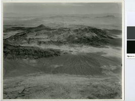
Aerial photograph of Frenchman Mountain, Nevada, circa 1949
Date
Archival Collection
Description
Aerial view looking south of Frenchman Mountain and the east side of Las Vegas Valley. Lake Mead can be seen in the distance.
Transcribed Notes: Transcribed from handwritten text on back of photo: "Frenchman Mt. Airview SE"
Image
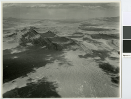
Aerial photograph looking northeast over Frenchman Mountain, circa 1949
Date
Archival Collection
Description
Aerial view of Frenchman Mountain and a little of the Las Vegas Wash area. Lake Mead can barely be seen in the distance.
Transcribed Notes: Transcribed from handwritten notes on back: "View NE Frenchman Mt left of center"
Image
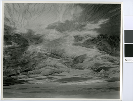
Aerial photograph of Sunrise Mountain and Nellis AFB area, circa 1949
Date
Archival Collection
Description
Sunrise Mountain and Nellis AFB area looking east.
Transcribed Notes: Transcribed from handwritten notes on back: "View SE. In foreground, large fan S.E. of Nellis Air Force"
Image
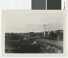
Photograph of road washout five miles southeast of Las Vegas, circa 1931
Date
Archival Collection
Description
Washout at 4-mile on the Boulder Highway, about 5 miles southeast of Las Vegas.
Transcribed Notes: Notes on photo sleeve: 'New pavement finished in May. Cloudburst in October took out culvert. Took out a Chevrolet and a Packard. About 5 mi. southeast of Las Vegas.' (James J. Hester, quote from W.A. Davis)
Image
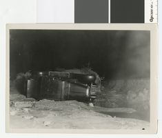
Photograph of cars overturned by a 4 mile cloudburst flood, circa 1931
Date
Archival Collection
Description
Car overturned by flood at 4-mile on the Boulder Highway, about 5 miles southeast of Las Vegas
Transcribed Notes: Handwritten collection note on back of photo: Cars overturned by cloudburst flood near wash by present-day Showboat. c. 1931-1932; Notes on photo sleeve: 'Photo taken at night with flash. Probably Chevrolet wrecked in flood in Vegas Wash. Water was 4 ft. deep on pavement.' (W.A. Davis, photographer)
Image
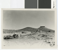
Photograph of leveling sand dunes west of the water tower in Boulder City, circa 1931
Date
Archival Collection
Description
Bulldozers leveling sand dunes west of the water tower in Boulder City.
Image