Search Results
Plat showing cultivated land in the Stewart Ranch, Las Vegas, Nevada, December 8, 1902
Date
1902-12-08
Archival Collection
Description
'John T. McWilliams, U.S.M. Surveyor, Goodsprings, Nevada.' 'Dec. 8th 1902.' '60-A-Pt.II' handwritten in upper right corner. This is map of the Stewart Ranch, which was originally the Las Vegas Ranch, site of the Old Mormon Fort. Drawn with ink and colored pencil. Two holes punched on right side..
Image

Blueprint showing proposed pipeline for gravity water supply at Las Vegas, Nevada, February 16, 1905
Date
1905-02-16
Description
'Office of Chief Engineer, Los Angeles, Cal., Feb. 16, 1905.' '2-18-17' hand-printed in lower right corner. Proposed pipeline is printed in red. Scale [1:6,000]. 1 inch to 500 feet. San Pedro, Los Angeles & Salt Lake Railroad Company. Office of Chief Engineer
Image

Map showing location of the Las Vegas & Tonopah Railroad from Las Vegas to Bullfrog, Nevada, 1906
Date
1906
Archival Collection
Description
'Office of Chief Engineer' printed on map above date.
Image
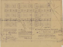
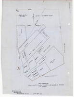
Map of Clark's Las Vegas Townsite, May 8, 1905
Date
1905-05-08
Archival Collection
Description
'Book 1, Page 37.' 'Dated: May 8th, 1905.' Subtitle: 'Being a sub-division of parts of the W.1/2 and the W.1/2 of the N.E.1/4 of Section 34 and the S.1/2 of the S.W.1/4 of Section 27 T.20 S.R. 61 E, Mount Diablo Base and Meridian, Lincoln County, Nevada. A Plat map. Blueline print. Scale [ca. 1:2,400]. 1 in. to 200 feet.
Text
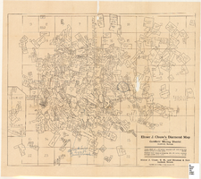
Map of the Goldfield Mining District, Goldfield, Nevada, 1907
Date
1907
Description
'Elmer J. Chute, E.M. and Olmstead and Rich, Goldfield, Nevada. Copyright 1907, by Elmer J. Chute, Goldfield, Nev.' Includes information on and prices for wall and pocket map with this title. Includes inset map. Includes township and range grid. Library's copy has Rochester GF. claim circled in blue ink , has a piece missing to the right of that claim, and has "Mohawk ledge, a lease by Davis & Shoemaker" written in blue ink at the center bottom of the map with a line in blue ink drawn to the Frances Mohawk claim.
Image
Men at the Princess Mill: photographic print
Date
1891-11-13
Archival Collection
Description
At Candelaria, Nevada: Re Princess Mill, Nov. 13, 1891. Identified from left to right: S.F. newspaperman (a director of Holmes Mining Co.), Col. W.J. Sutherland-Pres., Arthur Ashley (timekeeper), Capt. Hultz (a large owner), Lindsay Simpson. Front row: Col. David Howell Jackson (Supt.), Sam Jones with Col. Jackson's dog-Tion, Prof. Storch (company chemist).
Image

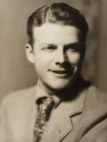
Headshot of Rex Bell: photographic print
Date
1959 to 2016
Archival Collection
Description
Bell Donation Oversize Photos
Image
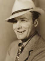
Headshot of Rex Bell: photographic print
Date
1959 to 2016
Archival Collection
Description
Bell Donation Oversize Photos
Image
Headshot of Rex Bell: photographic print
Date
1959 to 2016
Archival Collection
Description
Bell Donation Oversize Photos
Image