Search the Special Collections and Archives Portal
Search Results
Financial history of the project, 1997-2016
Level of Description
File
Archival Collection
Junior League of Las Vegas' Records on the Morelli House Preservation Project
To request this item in person:
Collection Number: MS-00836
Collection Name: Junior League of Las Vegas' Records on the Morelli House Preservation Project
Box/Folder: Box 01
Collection Name: Junior League of Las Vegas' Records on the Morelli House Preservation Project
Box/Folder: Box 01
Archival Component
Coyote Springs Project Area: map
Date
2000 (year approximate)
Archival Collection
Description
From the Jeff Van Ee Papers (MS-00470) -- Coyote Springs development -- Maps file.
Image

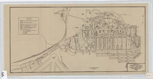
Cadastral map of Boulder City, Nevada, 1940
Date
1905-04-23
Description
A. M. S. Jan. 1940 in the lower left-hand corner. 1 map ; 61 x 30 cm. Cadastral map. "No. 40-1" in the lower right-hand corner. Shows block and lot numbers, buildings, water supply and sewage system, leased areas.
Image
Project management correspondence, 1989 to 1995
Level of Description
File
Archival Collection
MacDonald Ranch Development Records
To request this item in person:
Collection Number: MS-00892
Collection Name: MacDonald Ranch Development Records
Box/Folder: Box 064 (Restrictions apply)
Collection Name: MacDonald Ranch Development Records
Box/Folder: Box 064 (Restrictions apply)
Archival Component
1-22-60 to 36-22-60, 1978
Level of Description
File
Archival Collection
Elmo C. Bruner Architectural and Real Estate Appraisal Records
To request this item in person:
Collection Number: MS-00177
Collection Name: Elmo C. Bruner Architectural and Real Estate Appraisal Records
Box/Folder: Oversized Box 70
Collection Name: Elmo C. Bruner Architectural and Real Estate Appraisal Records
Box/Folder: Oversized Box 70
Archival Component
1-22-61 to 36-22-61, 1978
Level of Description
File
Archival Collection
Elmo C. Bruner Architectural and Real Estate Appraisal Records
To request this item in person:
Collection Number: MS-00177
Collection Name: Elmo C. Bruner Architectural and Real Estate Appraisal Records
Box/Folder: Oversized Box 71
Collection Name: Elmo C. Bruner Architectural and Real Estate Appraisal Records
Box/Folder: Oversized Box 71
Archival Component
1-22-62 to 34-22-62, 1978
Level of Description
File
Archival Collection
Elmo C. Bruner Architectural and Real Estate Appraisal Records
To request this item in person:
Collection Number: MS-00177
Collection Name: Elmo C. Bruner Architectural and Real Estate Appraisal Records
Box/Folder: Oversized Box 72
Collection Name: Elmo C. Bruner Architectural and Real Estate Appraisal Records
Box/Folder: Oversized Box 72
Archival Component

County agent project progress report, Formation of irrigation district, November 1, 1930
Date
1930-11-01
Archival Collection
Description
The formation of an irrigation district was being put on hold until all land ownership issues brought about by the construction of Hoover Dam were resolved. Report signed by John H. Wittwer as District Extension Agent. Project Number: State Office No. 172, Clark County No. 12. Name of Project: IX-Irrigation District - Formation of.
Text
CityLife August archive: digital photographs, 2009
Level of Description
File
Archival Collection
Bill Hughes Photographs
To request this item in person:
Collection Number: PH-00402
Collection Name: Bill Hughes Photographs
Box/Folder: Digital File 00
Collection Name: Bill Hughes Photographs
Box/Folder: Digital File 00
Archival Component
Pagination
Refine my results
Content Type
Creator or Contributor
Subject
Archival Collection
Digital Project
Resource Type
Year
Material Type
Place
Language
Records Classification

