Search Results
Map, city of Henderson, Nevada, August 1, 1955
Date
1955-08-01
Description
'Compiled by Pioneer Title Insurance & Trust Company.' '8/1/55.' Includes street index.
Image
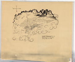
Hand-drawn map of Las Vegas, Nevada, circa 1855
Date
1850 to 1859
Description
Not drawn to scale. Relief shown pictorially. Facsimile of manuscript map. Oriented with north to left. Shows Las Vegas Mormon Fort, desert, mountains.
Image
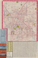
Las Vegas street map and Lake Mead Recreation Area pictorial map, 1979
Date
1979
Description
'Covering Las Vegas, North Las Vegas, Sunrise Manor, Winchester, Paradise and East Las Vegas from Craig Road on the north to Sunset Road on the south and Nellis Boulevard on the east to Jones Boulevard on the west' -- front panel. 'This tourist map has been published by CreaTours, Inc. in co-operation with the North Las Vegas Chamber of Commerce." 3rd ed. Scale [ca. 1:31,680. 1 in. to approx. 0.5 miles]. Includes indexes. Pictorial map of Lake Mead National Recreation Area on verso, by Cliff Segerblom. 'Lithographed by Creel Printing Company, Las Vegas, Nev.' Second edition, copyright 1977. 'Map not to scale due to artistic license.' Advertisements on map verso.
Text
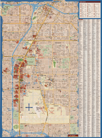
Maps of Las Vegas metropolitan area, Grand Canyon National Park and national parks near Las Vegas, Nevada, 2008
Date
2008
Description
'Cartography, H. Frommer, J. Habersetzer, R. Jendrzejewski, K. Berndtson, M. Grünke, P. Heine, K. Borch. ' On map verso: statistics on Las Vegas, U.S. time zones, maps of Las Vegas and region, Las Vegas and national parks, Grand Canyon National Park, and Grand Canyon Village. Relief is show by shading and colors on Las Vegas & national parks and Grand Canyon National Park maps. Index terms are in English, German, French, Italian, and Spanish. Includes inset map of Grand Canyon Village. Shows casinos, tourist attractions, shows, public buildings, shopping malls, parks, and golf courses. Original publisher: Borch GmbH. 7th ed. '1:20 000.' Original map is laminated.
Text

Map of Las Vegas and vicinity, Clark County, Nevada, November 1952
Date
1952-11
Description
'Copyright 1950. 3rd issue, November 1952.'
Image
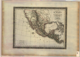
Map of Mexico and Central America, 1826
Date
1826
Description
'Par L. Vivien, Géographe, Gravée par Giraldon-Bovinet. 1826, Paris. Chez Ménard & Desenne, Rue Git-le-Coeur, No. 8.' Scale [ca. 1:15,840,000] (W 125°--W 75°/N 35°--N 05°). Relief shown by hachures. Hand colored. Atlas plate number in upper margin: no. 34. Ménard & Desenne
Image
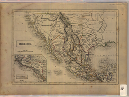
Map of Mexico, circa 1830s-1840s
Date
1830 to 1849
Description
'Engraved by S. Hall, Bury Strt., Bloomsby.' Inset map: Guatimala [sic] (including Honduras and Belize). Includes area of Southwestern states. Scale [ca. 1:12,400,000. 1 in. to approx. 200 miles] (W 125°-- W 85°/N 40°--N 15°). Relief shown by hachures. Prime meridian: Greenwich. Hand colored. 'XLIX'--outside of border at the lower right-hand. Published between 1836 and 1845?
Image
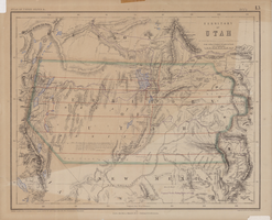
Map of territory of Utah, 1857
Date
1857
Description
31 x 39 cm. Relief shown by hachures and spot heights. "Entered in Sta. Hall London & according to act of Congress in the year 1857 by H.D. Rogers in the Clerks Office of the District Court of Massachusetts." Includes proposed Pacific railway routes. In upper margin: Atlas of United States &c., 13. Original publisher: John Murray, Scale: 3,450,000 of nature, 54 1.
Image

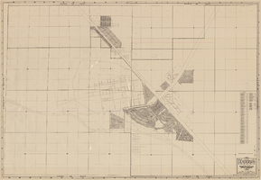
Map of city of Las Vegas, Nevada, October 1, 1940
Date
1940-10-01
Description
'Compiled by C.D. Baker, Oct. 1, 1940.' Scale [ca. 1:11,400]. 1 in. to 950 ft. Cadastral map.
Image

Map of Las Vegas and vicinity, Clark County, Nevada, December 1954
Date
1954-12
Description
'1955 map of Las Vegas and vicinity, Clark County, Nevada.' '4th issue, December 1954.' Cadastral map..
Image