Search Results
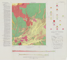
Geologic map of the Thirsty Canyon quadrangle, Nye County, Nevada, 1966
Date
1966
Description
57 x 46 cm., on sheet 83 x 91 cm., folded in envelope 30 x 24 cm. Relief shown by contours and spot heights. "Geology mapped in 1963." Includes 2 colored cross sections, index map, text, and quadrangle location map. "Prepared in cooperation with the U. S. Atomic Commission." Original publisher: Interior, Geological Survey, Series: Geologic quadrangle map GQ, Scale: 1:24 000.
Image
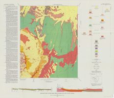
Geologic map of the Trail Ridge quadrangle, Nye County, Nevada, 1968
Date
1968
Description
58 x 46 cm., on sheet 79 x 91 cm., folded in envelope 30 x 24 cm. Relief shown by contours and spot heights. "Prepared in cooperation with the U.S. Atomic Energy Commission." "Base by U.S. Geological Survey, 1962." "Geology mapped in 1963." "Contour interval 20 feet." Includes text, 2 col. cross sections, quadrangle location map, and 1 index map. Original publisher: Interior, Geological Survey, Series: Geologic quadrangle map GQ, Scale: 1:24 000.
Image