Search Results
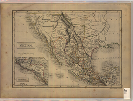
Map of Mexico, circa 1830s-1840s
Date
1830 to 1849
Description
'Engraved by S. Hall, Bury Strt., Bloomsby.' Inset map: Guatimala [sic] (including Honduras and Belize). Includes area of Southwestern states. Scale [ca. 1:12,400,000. 1 in. to approx. 200 miles] (W 125°-- W 85°/N 40°--N 15°). Relief shown by hachures. Prime meridian: Greenwich. Hand colored. 'XLIX'--outside of border at the lower right-hand. Published between 1836 and 1845?
Image
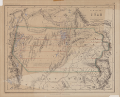
Map of territory of Utah, 1857
Date
1857
Description
31 x 39 cm. Relief shown by hachures and spot heights. "Entered in Sta. Hall London & according to act of Congress in the year 1857 by H.D. Rogers in the Clerks Office of the District Court of Massachusetts." Includes proposed Pacific railway routes. In upper margin: Atlas of United States &c., 13. Original publisher: John Murray, Scale: 3,450,000 of nature, 54 1.
Image

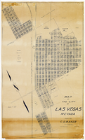
Map of city of Las Vegas, Nevada, October 1, 1940
Date
1940-10-01
Description
'Compiled by C.D. Baker, Oct. 1, 1940.' Scale [ca. 1:11,400]. 1 in. to 950 ft. Cadastral map.
Image

Map of Las Vegas and vicinity, Clark County, Nevada, December 1954
Date
1954-12
Description
'1955 map of Las Vegas and vicinity, Clark County, Nevada.' '4th issue, December 1954.' Cadastral map..
Image
Map of the city of Las Vegas, Nevada, March 1, 1927
Date
1927-03-01
Description
'Compiled by C.D. Baker, civil eningeer. 220 Fremont St. March 1, 1927.' 'C.E. Pembroke, selling agent.' Scale [ca. 1:3,600]. 1 in. to 300 ft. Cadastral map. Blueline print.
Image
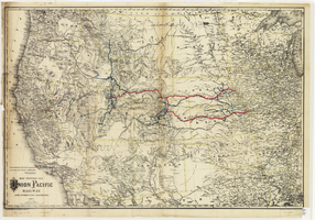
Map showing the Union Pacific Railway and connecting railroads, 1888
Date
1882
Description
Scale 1:3,800,000. 1 in. to 60 miles (W 126°--W 86°/N 48°--N 30°) ; 1 map : col. ; 57 x 85 cm ; Relief shown by hachures ; Prime meridian: Greenwich and Washington, D.C. ; "Entered according to act of Congress in the year 1882 by G.W. & C.B. Colton & Co. in the office of the Librarian of Congress, at Washington." ; Rufus Adams
Image
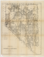
Map of Nevada, 1876
Date
1876
Description
'Compiled from the official records of the General Land Office and other sources by C. Roeser, principal draughtsman, G.L.O. Photo-lith & print. by Julius Bien, 16 & 18 Park Place, N.Y.' 'Department of the Interior, General Land Office, J.A. Williamson, Commissioner.' Scale [1:1,013,760]. 1 in. to 16 miles (W 120°--W 114°/N 42°--N 35°) .Relief shown by hachures. Shows township and range grid. Department of the Interior, General Land Office.
Image
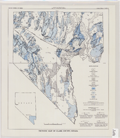
Tectonic map of Clark County, Nevada, 1965
Date
1965
Description
'Nevada Bureau of Mines. Bulletin 62, plate 5.' 'Prepared cooperatively by the U.S. Geological Survey.' Shows types of rocks as well as faults. Scale [ca. 1:760,320. 1 in. to approx. 12 miles] (W 116°--W 114°/N 37°--N 35°). Bulletin (Nevada Bureau of Mines)
62.
62.
Image
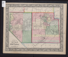
County map of Utah and Nevada, 1865
Date
1865
Description
'Entered according to Act of Congress in the year 1865 by S. Augustus Mitchell, Jr. in the Clerk's office of the District Court of the U.S. for the Eastern District of Pennsylvania . Drawn and engraved by W.H. Gamble, Philadelphia.' Shows roads, overland telegraph route, and other features. Relief shown by hachures and spot heights. Prime meridians: Greenwich and Washington. Scale [ca. 1:2,787,840] (W 120°--W 109°/N 43°--N 36° 59?).
Image
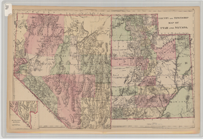
County and township map of Utah and Nevada, 1881
Date
1881
Description
'Entered according to Act of Congress in the year 1881 by S. Augustus Mitchell in the Office of the Librarian of Congress at Washington.' Relief shown by hachures. Prime meridians: Greenwich and Washington. In upper-right corner: 91. Shows range and township grid. Includes inset of southern portion of Nevada Scale [ca. 1:1,750,000]. 1 in. to approx. 27 miles (W 120°--W 109°/N 42°--N 35°).
Image