
Search the Special Collections and Archives Portal

Search Results

Display    Results Per Page
Displaying results 6221 - 6230 of 17771

Georgia Lewis Photograph Collection

Identifier

PH-00183

Abstract

The Georgia Lewis Photograph Collection contains black-and-white photographic prints and negatives primarily depicting Kyle Ranch, also known as Boulderado Ranch and Taylor Ranch, between approximately 1900 and 1950. The collection also features locations throughout Nevada such as Sloan, Panaca, Overton, and Indian Springs. Other images depict various individuals, including figures such as Grant Sawyer and J. Edgar Hoover, in Nevada locations and around the United States including Washington and Los Angeles, California.

Archival Collection

Albert C. Phillips Photograph Collection

Identifier

PH-00159

Abstract

The Albert C. Phillips Photograph Collection is comprised of sixteen black-and-white photographic reprints and four photographic negatives depicting buildings in Caliente, Nevada which were originally taken between 1900 to 1967 and reproduced in approximately 1999 to 2005.

Archival Collection

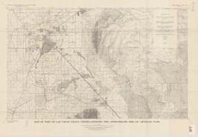
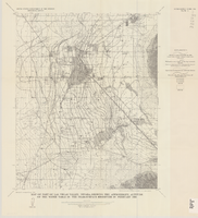
Map of part of Las Vegas Valley, Nevada, showing the approximate area of artesian flow, 1965

Date

1965

Description

At top of map: 'United States Department of the Interior, Geological Survey. Water supply paper 1780, plate 2.' At bottom of map: 'Base from U.S. Geological Survey Las Vegas (1952) and Henderson (1952) quadrangles.' 'Interior--Geological Survey, Washigton, D.C.--1965--W63358.' Relief shown by contours. Includes township and range lines. Thematic map. Scale 1:62,500 (W 115°15´--W 114°45´/N 36°15´--N 36°00´). Series: Water-supply paper (Washington, D.C.)
1780. Originally published as plate 2 of Available water supply of the Las Vegas ground-water basin, Nevada, by Glenn T. Malmberg, published by the Geological Survey in 1965 as its Water-supply paper 1780.

Image

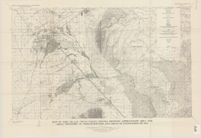
Map of part of Las Vegas Valley, Nevada, showing the approximate altitude of the water table in the near-surface reservoir in February 1956

Date

1965

Description

Genre/Form: Thematic maps. Scale 1:62,500 (W 115°15´--W 115°00´/N 36°15´--N 36°00´). 1 map ; 45 x 36 cm. Series: Water-supply paper (Washington, D.C.) ; 1780. Relief shown by contours. Originally published as plate 8 of Available water supply of the Las Vegas ground-water basin, Nevada, by Glenn T. Malmberg, published by the Geological Survey in 1965 as its Water-supply paper 1780. Includes township and range lines. Interior, Geological Survey

Image

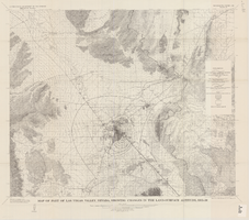
Map of part of Las Vegas Valley, Nevada, showing approximate area and areal densities of phreatophytes and areas in cultivation in 1912

Date

1965

Description

Genre/Form: Thematic maps. Scale 1:62,500 (W 115°15´--W 114°45´/N 36°15´--N 36°00´). 1 map : col. ; 45 x 72 cm. Series: Water-supply paper (Washington, D.C.) ; 1780. Relief shown by contours. Originally published as plate 11 of Available water supply of the Las Vegas ground-water basin, Nevada, by Glenn T. Malmberg, published by the Geological Survey in 1965 as its Water-supply paper 1780. Includes township and range lines. Interior, Geological Survey

Image

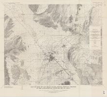
Map of part of Las Vegas Valley, Nevada, showing changes in the land-surface altitude, 1935-50

Date

1965

Description

Genre/Form: Topographic maps. Scale 1:96,000 (W 115°30´--W 114°45´/N 36°30´--N 36°00´). 1 map ; 58 x 70 cm. Series: Water-supply paper (Washington, D.C.) ; 1780. Relief shown by contours. "After Smith, Vetter, Cummings, and others (1960, p. 34)." Originally published as plate 13 of Available water supply of the Las Vegas ground-water basin, Nevada, by Glenn T. Malmberg, published by the Geological Survey in 1965 as its Water-supply paper 1780. Includes township and range lines. Interior, Geological Survey

Image

Map of part of Las Vegas Valley, Nevada, showing changes in the land-surface altitude, 1935 to 1940-41

Date

1965

Description

Genre/Form: Topographic map. Scale 1:96,000 (W 115°30´--W 114°45´/N 36°30´--N 36°00´). 1 map ; 58 x 70 cm. Series: Water-supply paper (Washington, D.C.) ; 1780. Relief shown by contours. "After C.R. Longwell (written communication, 1954, fig. 30)." Originally published as plate 12 of Available water supply of the Las Vegas ground-water basin, Nevada, by Glenn T. Malmberg, published by the Geological Survey in 1965 as its Water-supply paper 1780. Includes township and range lines. Interior, Geological Survey

Image