Search Results
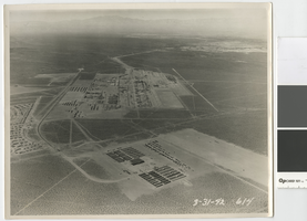
Aerial photograph of the Basic Magnesium Inc. plant, Henderson, Nevada, March 31, 1942
Date
Archival Collection
Description
Aerial view of the Basic Magnesium plant looking west over the Las Vegas Valley towards the Spring Mountains.
Image
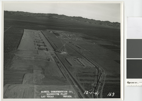
Aerial photograph showing construction activities, Basic Magnesium Inc., Henderson, Nevada, December 1, 1941
Date
Archival Collection
Description
View of construction of the Basic Magnesium Inc. plant from the air looking east.
Transcribed Notes: Transcribed from front of photo: "McNeil construction Co. Magnesium plant, Las Vegas, Nevada, 12-1-41"
Image
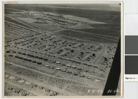
Aerial photograph of Henderson, Nevada, March 31, 1942
Date
Archival Collection
Description
Early aerial view of Henderson, Nevada looking northwest over the Basic Magnesium plant and Whitney Mesa, showing demountable houses in various stages of construction..
Image
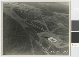
Aerial photograph showing Henderson, Nevada and the Basic Magnesium Inc. plant, March 31, 1942
Date
Archival Collection
Description
Aerial view of Henderson and the Basic Magnesium plant showing the terminal reservoir, demountable housing, and temporary boarding camp.
Image
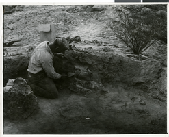
Photograph of Pueblo Grande de Nevada, circa mid to late 1920s
Date
Archival Collection
Description
Image
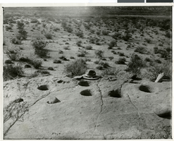
Photograph of Pueblo Grand de Nevada, circa mid to late 1920s
Date
Archival Collection
Description
Image
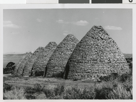
Photograph of Ward charcoal ovens, White Pine County, Nevada, 1960-1961
Date
Archival Collection
Description
Image
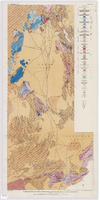
Geologic map of the Atomic Energy Commission Nevada Proving Grounds Area, Nye and Clark Counties, Nevada, 1952
Date
Description
'At top of map: ' United States Department of the Interior. Geological Survey.' ' Bulletin 1021, Plate 32.' At bottom of map: 'Geology by Donald E. Hibbard and Mike S. Johnson, 1952.' 'Base from USAF Aeronautical Chart and Information Service, April 1952.' 'Interior--Geological Survey, Washington, D.C. MR-3767.' Scale 1:63,360 (W 116°10--W 115°55/N 37°15--N 36°40)
Geological Survey bulletin, 1021
Image

Transcript of interview with Thalia Dondero by Susan Scott, March 18, 1978
Date
Archival Collection
Description
On March 18, 1978, Susan Scott interviewed Thalia Dondero (born 1921 in Greeley, Colorado) about her experiences in Nevada and more specifically about her work as a Clark County Commissioner. Dondero first speaks about her background and the circumstances which led her to move to Las Vegas. She also talks about her children, her work with the Parent-Teacher Association, and her service with the Nevada State Park Commission. She also mentions some of her lobbying work for the development of state parks, including a project by National Geographic in which she visited multiple parks, and she later describes the development of the Las Vegas Strip. At the end of the interview, Dondero talks about her involvement in various organizations, her consideration for running for governor, and some of the topics she handles as a commissioner for the county.
Text
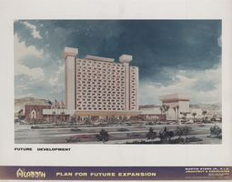
Proposal for the Aladdin expansion (Las Vegas), circa 1976
Date
Archival Collection
Description
Bound proposal for an Aladdin expansion including artist's conceptions, site map, and drawings of main architectural elements. This project was not built. Folder on last page marked "additional criteria" is empty.
Site Name: Aladdin Hotel
Address: 3667 Las Vegas Boulevard South, Las Vegas, NV
Image