Search Results


Booklet of construction progress photographs of the International Hotel, Las Vegas, February 1969
Date
Archival Collection
Description
Image
Southern Nevada Historical Society Photograph Collection on Basic Magnesium, Inc.
Identifier
Abstract
The Southern Nevada Historical Society Photograph Collection on Basic Magnesium, Inc. contains photographs of the construction of Basic Magnesium Inc.'s plants and buildings from 1941 to 1942. The photographs primarily depict aerial views of the plant site and various buildings, including the administration building, tent camp, chlorination buildings, electrolysis facilities, electrical distribution systems, and warehouses. The photographs also depict Lake Mead and the early buildings in Henderson, Nevada.
Archival Collection
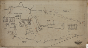
Map showing the proposed improvement of Las Vegas Springs, Las Vegas (Nev.), Clark County (Nev.), 1916
Date
Description
Scale [ca. 1:240]. 1 in. to 20 feet. -- Scale [ca. 1:2,400]. 1 in. to 200 ft. Vertical scale [ca. 1:48]. 1 in. to 4 feet. -- Scale [ca. 1:4,800]. 1 in. to 100 feet ; 1 map : col. ; 40 x 78 cm ; "Scale as noted." ; "Exhibit 'A'." ; "Approved Sept. 21, 1916." ; "Div.Engr."--Lower right corner ; "W.E.J."--Lower left corner ; "L-44-50to61. T-75-17&46."--Upper left corner ; Includes discharge figures and plans for improvements to springs ; Library's copy has "Proposed layout" written on it in pencil ; Contents: Detail at springs -- Profile -- Alignment ;
Image

Topographic map of Cane Spring, Nevada quadrangle, 1961
Date
Description
For sale by the U.S. Geological Survey
Image
Midas Muffler, 1985 May 20
Level of Description
Scope and Contents
This set includes: index sheet, site plans, wall sections, interior elevations, floor plans, redlining, foundation plans, roof plans, framing plans, exterior elevations, building sections, construction details, finish/door/window schedules, plumbing plans, mechanical plans and general specifications.
This set includes drawings for Donn Enterprises (client).
Archival Collection
Collection Name: Gary Guy Wilson Architectural Drawings
Box/Folder: Roll 284
Archival Component
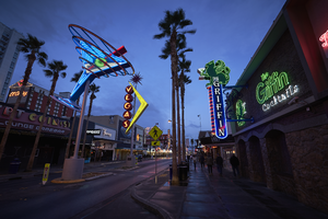
Photographs of East Fremont Street signs, Las Vegas (Nev.), 2016
Date
Archival Collection
Description
Site name: Fremont Street (Las Vegas, Nev.)
Site address: Fremont St
Sign keywords: Neon; Incandescent; Back to back; Sculptural; Pole sign; Oscillating
Mixed Content
