Search Results
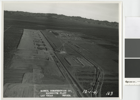
Aerial photograph showing construction activities, Basic Magnesium Inc., Henderson, Nevada, December 1, 1941
Date
Archival Collection
Description
View of construction of the Basic Magnesium Inc. plant from the air looking east.
Transcribed Notes: Transcribed from front of photo: "McNeil construction Co. Magnesium plant, Las Vegas, Nevada, 12-1-41"
Image
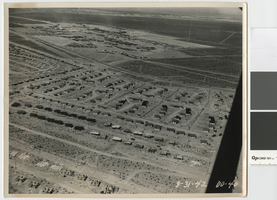
Aerial photograph of Henderson, Nevada, March 31, 1942
Date
Archival Collection
Description
Early aerial view of Henderson, Nevada looking northwest over the Basic Magnesium plant and Whitney Mesa, showing demountable houses in various stages of construction..
Image
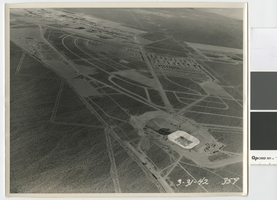
Aerial photograph showing Henderson, Nevada and the Basic Magnesium Inc. plant, March 31, 1942
Date
Archival Collection
Description
Aerial view of Henderson and the Basic Magnesium plant showing the terminal reservoir, demountable housing, and temporary boarding camp.
Image
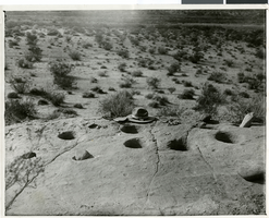
Photograph of Pueblo Grande de Nevada, circa mid to late 1920s
Date
Archival Collection
Description
Image
Photograph of Pueblo Grand de Nevada, circa mid to late 1920s
Date
Archival Collection
Description
Image
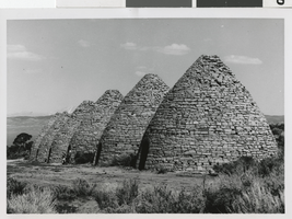
Photograph of Ward charcoal ovens, White Pine County, Nevada, 1960-1961
Date
Archival Collection
Description
Image
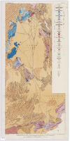
Geologic map of the Atomic Energy Commission Nevada Proving Grounds Area, Nye and Clark Counties, Nevada, 1952
Date
Description
'At top of map: ' United States Department of the Interior. Geological Survey.' ' Bulletin 1021, Plate 32.' At bottom of map: 'Geology by Donald E. Hibbard and Mike S. Johnson, 1952.' 'Base from USAF Aeronautical Chart and Information Service, April 1952.' 'Interior--Geological Survey, Washington, D.C. MR-3767.' Scale 1:63,360 (W 116°10--W 115°55/N 37°15--N 36°40)
Geological Survey bulletin, 1021
Image
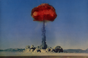
Postcard of an atomic explosion, Nevada, circa 1950s
Date
Archival Collection
Description
Image
Mike Gunter oral history interview, 2013 February 01
Level of Description
Scope and Contents
After graduating from Bonanza High School in Las Vegas, Nevada, Gunter worked for Mercy Ambulance. He later worked as a paramedic at the Mercury Test Site, which helped pay for medical school at the University of Nevada.
Archival Collection
Collection Name: History of Emergency Medical Services in Nevada Oral History Interviews
Box/Folder: Digital File 00
Archival Component
Smoke Ranch: Phase II, 1988 November 26
Level of Description
Scope and Contents
This set includes: site plans, grading plans, water and sewer plans and utility plans.
This set includes drawings for the Mueller Group (client) by Bronken Engineering Chartered (engineer).
Archival Collection
Collection Name: Gary Guy Wilson Architectural Drawings
Box/Folder: Roll 506
Archival Component